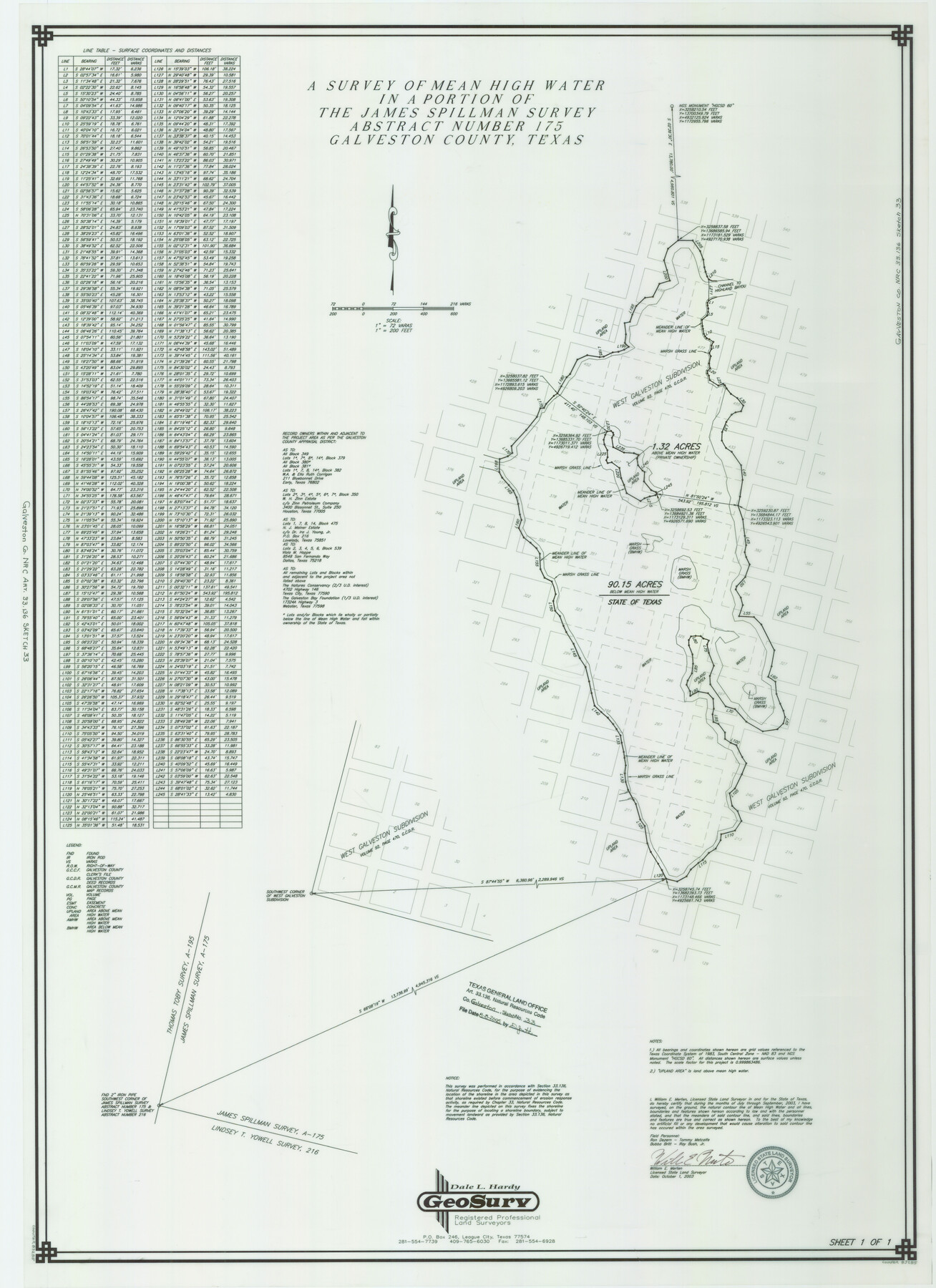
Galveston County NRC Article 33.136 Sketch 33
A Survey of Mean High Water in Portion of the James Spillman Survey, Abstract 175
-
Map/Doc
83285
-
Collection
General Map Collection
-
Object Dates
2003/10/1 (Creation Date)
2005/8/8 (File Date)
-
People and Organizations
GeoSurv (Publisher)
GeoSurv (Printer)
William E. Merten (Surveyor/Engineer)
-
Counties
Galveston
-
Subjects
Surveying CBS
-
Height x Width
42.5 x 30.9 inches
108.0 x 78.5 cm
-
Medium
mylar, print
-
Comments
Survey located about 10 miles North 85 degrees West of Galveston, Texas.
Part of: General Map Collection
Rusk County Working Sketch 27

Print $20.00
- Digital $50.00
Rusk County Working Sketch 27
1937
Size 35.6 x 29.3 inches
Map/Doc 63663
Map of Limestone County

Print $20.00
- Digital $50.00
Map of Limestone County
1869
Size 22.1 x 22.4 inches
Map/Doc 3818
Young County Working Sketch 5

Print $20.00
- Digital $50.00
Young County Working Sketch 5
1919
Size 14.3 x 7.1 inches
Map/Doc 62028
Houston County Working Sketch 20

Print $20.00
- Digital $50.00
Houston County Working Sketch 20
1979
Size 26.7 x 24.0 inches
Map/Doc 66250
Cass County Rolled Sketch OPD

Print $20.00
- Digital $50.00
Cass County Rolled Sketch OPD
1936
Size 29.6 x 24.9 inches
Map/Doc 5415
Parmer County Sketch File 1

Print $28.00
- Digital $50.00
Parmer County Sketch File 1
1902
Size 10.6 x 8.2 inches
Map/Doc 33621
Fort Bend County State Real Property Sketch 14

Print $40.00
- Digital $50.00
Fort Bend County State Real Property Sketch 14
1985
Size 36.7 x 35.6 inches
Map/Doc 61688
El Paso County Sketch File 14

Print $20.00
- Digital $50.00
El Paso County Sketch File 14
1922
Size 24.0 x 17.2 inches
Map/Doc 11452
Terrell County Working Sketch 48

Print $40.00
- Digital $50.00
Terrell County Working Sketch 48
1958
Size 59.3 x 42.2 inches
Map/Doc 62141
Map of Kendall County

Print $20.00
- Digital $50.00
Map of Kendall County
1899
Size 36.7 x 34.4 inches
Map/Doc 4999
Flight Mission No. DIX-6P, Frame 180, Aransas County

Print $20.00
- Digital $50.00
Flight Mission No. DIX-6P, Frame 180, Aransas County
1956
Size 19.0 x 22.6 inches
Map/Doc 83842
Dallas County Sketch File 19

Print $20.00
- Digital $50.00
Dallas County Sketch File 19
Size 17.1 x 17.9 inches
Map/Doc 11287
You may also like
Throckmorton Co.

Print $20.00
- Digital $50.00
Throckmorton Co.
1898
Size 41.2 x 35.9 inches
Map/Doc 16895
Map of the Oregon Territory by the U.S. Ex. Ex.

Print $20.00
- Digital $50.00
Map of the Oregon Territory by the U.S. Ex. Ex.
1841
Size 26.2 x 37.3 inches
Map/Doc 94060
Chambers County Working Sketch 27

Print $20.00
- Digital $50.00
Chambers County Working Sketch 27
1982
Size 24.9 x 25.2 inches
Map/Doc 68010
Gonzales County Sketch File 12

Print $4.00
- Digital $50.00
Gonzales County Sketch File 12
Size 10.8 x 8.7 inches
Map/Doc 24394
Edwards County Sketch File 31

Print $6.00
- Digital $50.00
Edwards County Sketch File 31
1926
Size 14.5 x 8.8 inches
Map/Doc 21762
The Republic County of Goliad. Proposed, Late Fall 1837

Print $20.00
The Republic County of Goliad. Proposed, Late Fall 1837
2020
Size 15.1 x 21.7 inches
Map/Doc 96147
[Aransas Wildlife Refuge]
![2081, [Aransas Wildlife Refuge], General Map Collection](https://historictexasmaps.com/wmedia_w700/maps/2081.tif.jpg)
Print $40.00
- Digital $50.00
[Aransas Wildlife Refuge]
1965
Size 55.6 x 42.9 inches
Map/Doc 2081
Flight Mission No. BRA-7M, Frame 145, Jefferson County

Print $20.00
- Digital $50.00
Flight Mission No. BRA-7M, Frame 145, Jefferson County
1953
Size 16.0 x 16.0 inches
Map/Doc 85539
John Slaughter Ranch

Print $40.00
- Digital $50.00
John Slaughter Ranch
Size 38.0 x 52.7 inches
Map/Doc 89952
Comanche County Sketch File 2

Print $40.00
- Digital $50.00
Comanche County Sketch File 2
1849
Size 16.0 x 12.9 inches
Map/Doc 19053
Crane County Rolled Sketch 7

Print $20.00
- Digital $50.00
Crane County Rolled Sketch 7
1927
Size 33.4 x 44.8 inches
Map/Doc 8679
Pts. of G&M M-20, Y2 & H&TC 46

Print $2.00
- Digital $50.00
Pts. of G&M M-20, Y2 & H&TC 46
Size 6.6 x 15.2 inches
Map/Doc 91724