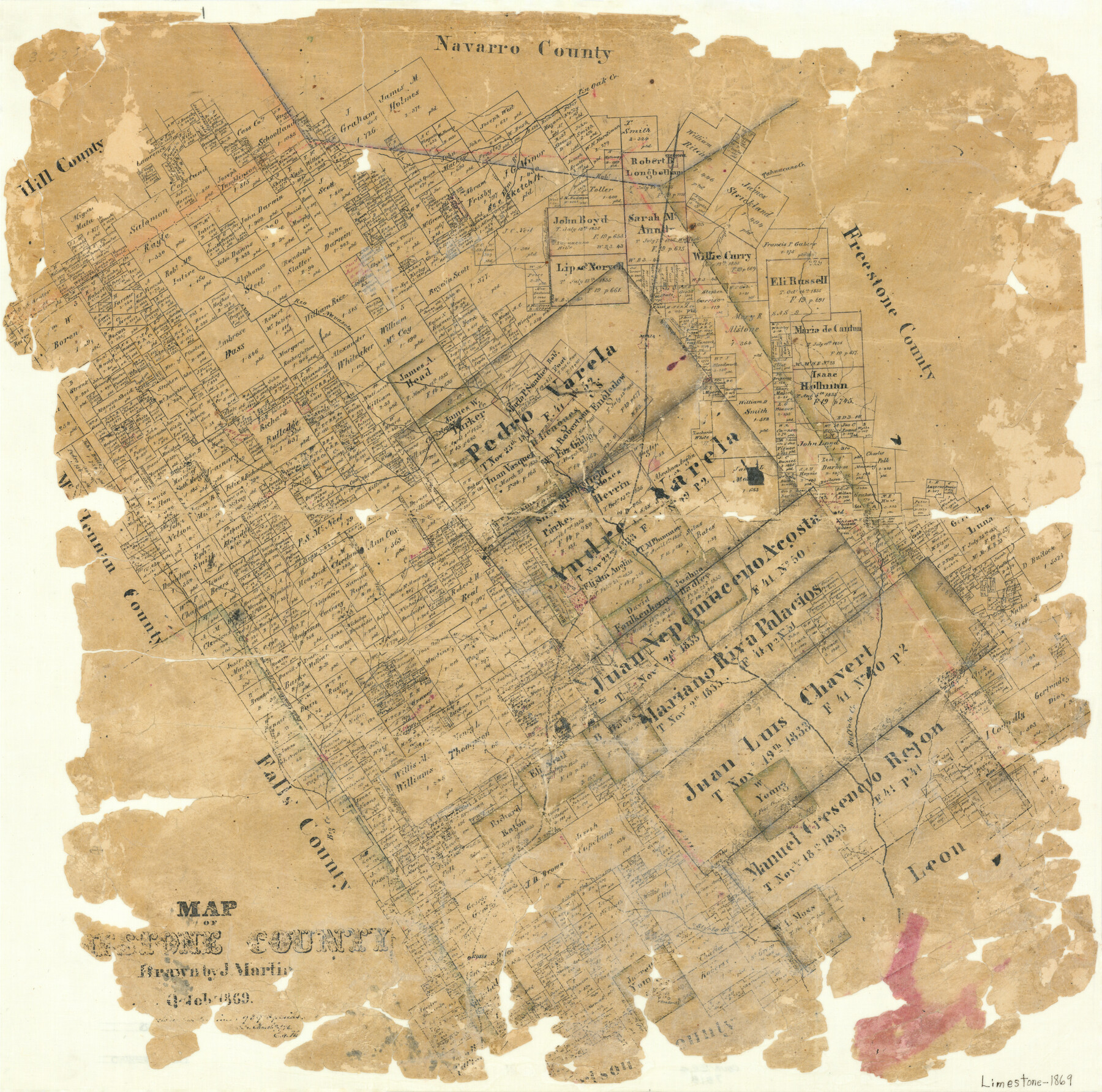
Map of Limestone County
-
Map/Doc
3818
-
Collection
General Map Collection
-
Object Dates
10/1869 (Creation Date)
-
People and Organizations
Joseph Martin (Draftsman)
-
Counties
Limestone
-
Subjects
County
-
Height x Width
22.1 x 22.4 inches
56.1 x 56.9 cm
-
Features
Thornton
Horn Hills
Lynn Creek
McKinzie Creek
[Ho]rse Creek
Christmas Creek
Sandy Creek
Sanders Creek
Headsville
North Elm Fork [of Big Creek]
Big Creek
Little Brazos [River]
Kosse
Steels Creek
Lambs Creek
Pin Oak Creek
Buffalo Creek
Lake Creek
Springfield
Elm Creek
Burleson Creek
Mexia
Rio Navasoto
Tahuacano Hills
Wolf Fork [of Tahuacano Creek]
Elm Fork [of Tahuacano Creek]
Tahuacano Creek
Tehuacana
Elm Branch [of Pin Oak Creek]
Part of: General Map Collection
Current Miscellaneous File 5

Print $8.00
- Digital $50.00
Current Miscellaneous File 5
1946
Size 11.3 x 8.8 inches
Map/Doc 73727
Controlled Mosaic by Jack Amman Photogrammetric Engineers, Inc - Sheet 53

Print $20.00
- Digital $50.00
Controlled Mosaic by Jack Amman Photogrammetric Engineers, Inc - Sheet 53
1954
Size 20.0 x 24.0 inches
Map/Doc 83512
[Map of Denton County]
![4529, [Map of Denton County], General Map Collection](https://historictexasmaps.com/wmedia_w700/maps/4529-1.tif.jpg)
Print $20.00
- Digital $50.00
[Map of Denton County]
1853
Size 24.5 x 29.1 inches
Map/Doc 4529

Leon County Working Sketch 47

Print $20.00
- Digital $50.00
Leon County Working Sketch 47
1980
Size 29.3 x 25.8 inches
Map/Doc 70446
Brewster County Rolled Sketch 125

Print $179.00
- Digital $50.00
Brewster County Rolled Sketch 125
1889
Map/Doc 43141
Runnels County Rolled Sketch 39

Print $20.00
- Digital $50.00
Runnels County Rolled Sketch 39
Size 34.3 x 31.6 inches
Map/Doc 7526
Calhoun County Rolled Sketch 30

Print $20.00
- Digital $50.00
Calhoun County Rolled Sketch 30
1974
Size 18.6 x 27.6 inches
Map/Doc 5495

Crane County Working Sketch 28

Print $40.00
- Digital $50.00
Crane County Working Sketch 28
1972
Size 49.4 x 49.1 inches
Map/Doc 68305
Hutchinson County Working Sketch 1

Print $3.00
- Digital $50.00
Hutchinson County Working Sketch 1
Size 9.5 x 17.0 inches
Map/Doc 66359
Milam County Working Sketch 14

Print $20.00
- Digital $50.00
Milam County Working Sketch 14
1904
Size 28.2 x 16.7 inches
Map/Doc 71029
You may also like
Ward County Working Sketch 28

Print $40.00
- Digital $50.00
Ward County Working Sketch 28
1964
Size 60.9 x 29.1 inches
Map/Doc 72334
Harris County Working Sketch 63

Print $20.00
- Digital $50.00
Harris County Working Sketch 63
1954
Size 34.0 x 36.8 inches
Map/Doc 65955
Maps & Lists Showing Prison Lands (Oil & Gas) Leased as of June 1955

Digital $50.00
Maps & Lists Showing Prison Lands (Oil & Gas) Leased as of June 1955
1930
Size 24.4 x 26.8 inches
Map/Doc 62876
Map of the Fort Worth & Denver City Railway

Print $20.00
- Digital $50.00
Map of the Fort Worth & Denver City Railway
1887
Size 19.3 x 15.1 inches
Map/Doc 64434
Rusk County Rolled Sketch OBS

Print $20.00
- Digital $50.00
Rusk County Rolled Sketch OBS
1937
Size 26.3 x 21.8 inches
Map/Doc 7550
General Highway Map, Lynn County, Texas

Print $20.00
General Highway Map, Lynn County, Texas
1940
Size 18.2 x 24.9 inches
Map/Doc 79182

Hansford County Sketch File 8

Print $6.00
- Digital $50.00
Hansford County Sketch File 8
1927
Size 11.3 x 8.7 inches
Map/Doc 24960
Briscoe County Rolled Sketch 11

Print $20.00
- Digital $50.00
Briscoe County Rolled Sketch 11
1913
Size 25.0 x 21.6 inches
Map/Doc 5328


Sterling County Working Sketch 2

Print $20.00
- Digital $50.00
Sterling County Working Sketch 2
1941
Size 19.9 x 26.2 inches
Map/Doc 63984