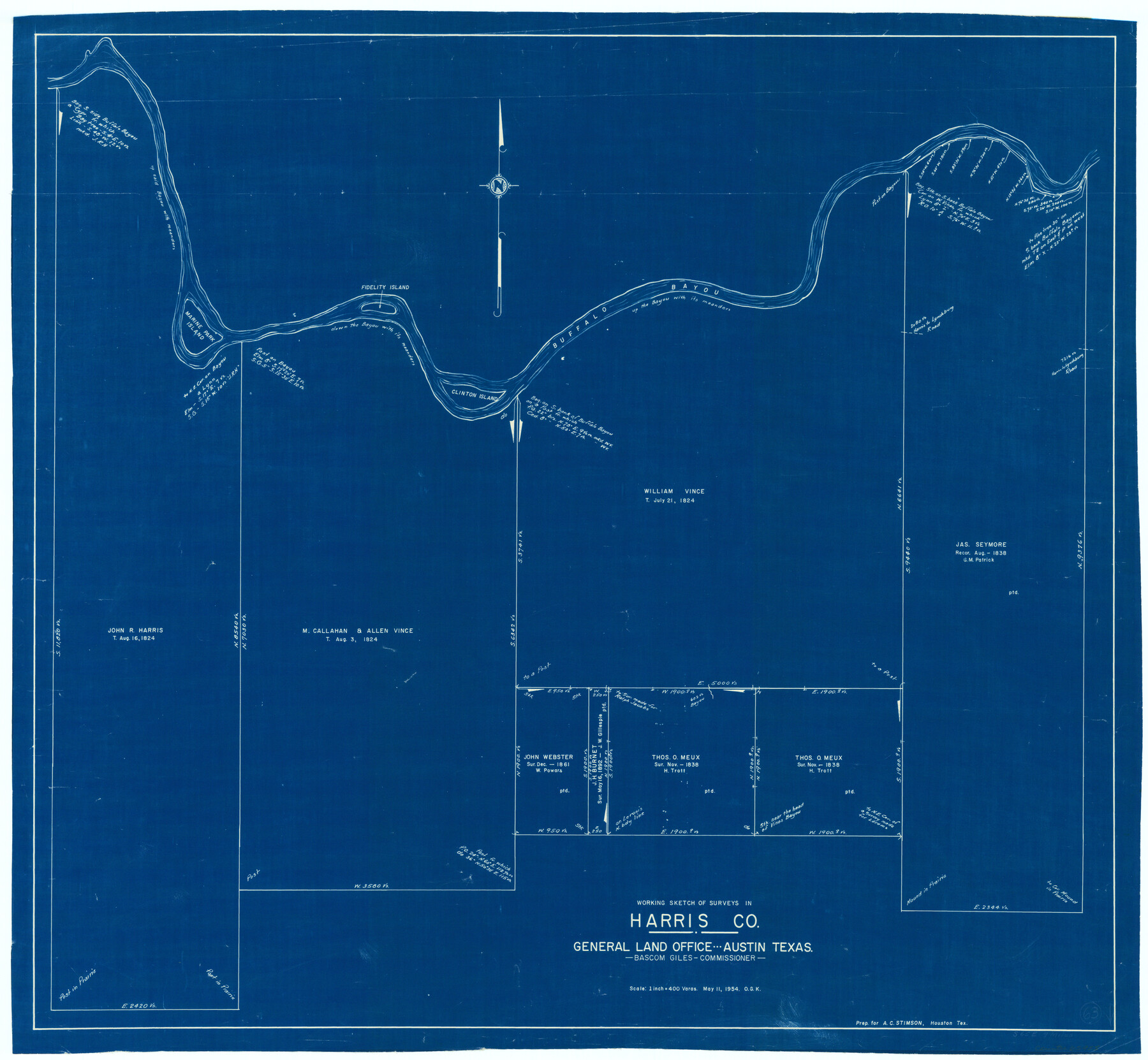
Harris County Working Sketch 63
-
Map/Doc
65955
-
Collection
General Map Collection
-
Object Dates
5/11/1954 (Creation Date)
-
People and Organizations
Otto G. Kurio (Draftsman)
-
Counties
Harris
-
Subjects
Surveying Working Sketch
-
Height x Width
34.0 x 36.8 inches
86.4 x 93.5 cm
-
Scale
1" = 400 varas
Part of: General Map Collection
Dallas County Sketch File 10

Print $4.00
- Digital $50.00
Dallas County Sketch File 10
1858
Size 12.5 x 8.2 inches
Map/Doc 20414
Galveston County NRC Article 33.136 Sketch 86

Print $42.00
- Digital $50.00
Galveston County NRC Article 33.136 Sketch 86
2018
Size 24.0 x 36.0 inches
Map/Doc 95388
Right of Way and Track Map, International & Gt. Northern Ry. operated by the International & Gt. Northern Ry. Co. Gulf Division, Mineola Branch

Print $40.00
- Digital $50.00
Right of Way and Track Map, International & Gt. Northern Ry. operated by the International & Gt. Northern Ry. Co. Gulf Division, Mineola Branch
1917
Size 26.3 x 125.4 inches
Map/Doc 64700
Castro County Sketch File 3a

Print $4.00
- Digital $50.00
Castro County Sketch File 3a
1888
Size 14.1 x 8.4 inches
Map/Doc 17460
San Augustine County Boundary File 1

Print $17.00
- Digital $50.00
San Augustine County Boundary File 1
Size 9.3 x 12.2 inches
Map/Doc 58540
Flight Mission No. DCL-6C, Frame 3, Kenedy County

Print $20.00
- Digital $50.00
Flight Mission No. DCL-6C, Frame 3, Kenedy County
1943
Size 18.8 x 22.5 inches
Map/Doc 85863
Irion County Working Sketch 6

Print $20.00
- Digital $50.00
Irion County Working Sketch 6
1935
Size 16.6 x 30.8 inches
Map/Doc 66415
PSL Field Notes for Blocks 1 and 2, Hansford and Sherman Counties, Blocks 3 and 4, Hansford County, Blocks A1, A2, A4, A5, and A6 in Hartley County, Block C0 in Hockley, Lubbock, Lynn, and Terry Counties, and Blocks A and B in Kent County

PSL Field Notes for Blocks 1 and 2, Hansford and Sherman Counties, Blocks 3 and 4, Hansford County, Blocks A1, A2, A4, A5, and A6 in Hartley County, Block C0 in Hockley, Lubbock, Lynn, and Terry Counties, and Blocks A and B in Kent County
Map/Doc 81655
Upton County Rolled Sketch 20

Print $40.00
- Digital $50.00
Upton County Rolled Sketch 20
1933
Size 53.0 x 36.8 inches
Map/Doc 10041
Map of the British Isles to illustrate Olney's school geography (Inset: Shetland Isles)

Print $20.00
- Digital $50.00
Map of the British Isles to illustrate Olney's school geography (Inset: Shetland Isles)
1844
Size 12.1 x 9.5 inches
Map/Doc 93547
Dimmit County Sketch File 62

Print $8.00
- Digital $50.00
Dimmit County Sketch File 62
2012
Size 11.0 x 8.5 inches
Map/Doc 93631
Flight Mission No. CLL-1N, Frame 35, Willacy County

Print $20.00
- Digital $50.00
Flight Mission No. CLL-1N, Frame 35, Willacy County
1954
Size 18.5 x 22.1 inches
Map/Doc 87016
You may also like
The Judicial District/County of Burleson. Created, January 15, 1842

Print $20.00
The Judicial District/County of Burleson. Created, January 15, 1842
2020
Size 14.1 x 21.7 inches
Map/Doc 96320
Survey Gulf to Beaumont and Orange, Texas

Print $20.00
- Digital $50.00
Survey Gulf to Beaumont and Orange, Texas
1929
Size 29.3 x 41.7 inches
Map/Doc 3089
[Block B9 and 3KA]
![90329, [Block B9 and 3KA], Twichell Survey Records](https://historictexasmaps.com/wmedia_w700/maps/90329-1.tif.jpg)
Print $20.00
- Digital $50.00
[Block B9 and 3KA]
Size 31.4 x 17.8 inches
Map/Doc 90329
Sketch in Southeastern Portion of Stephens County

Print $20.00
- Digital $50.00
Sketch in Southeastern Portion of Stephens County
1919
Size 29.0 x 21.7 inches
Map/Doc 91841
Map of Public Land on Mustang Island

Print $20.00
- Digital $50.00
Map of Public Land on Mustang Island
Size 21.9 x 17.5 inches
Map/Doc 82315
Crockett County Working Sketch Graphic Index - northwest part - sheet A

Print $40.00
- Digital $50.00
Crockett County Working Sketch Graphic Index - northwest part - sheet A
1983
Size 37.0 x 48.2 inches
Map/Doc 76509
[Gunter & Munson, Maddox Bros. & Anderson Block F] / [PSL Block B19]
![91852, [Gunter & Munson, Maddox Bros. & Anderson Block F] / [PSL Block B19], Twichell Survey Records](https://historictexasmaps.com/wmedia_w700/maps/91852-1.tif.jpg)
Print $20.00
- Digital $50.00
[Gunter & Munson, Maddox Bros. & Anderson Block F] / [PSL Block B19]
Size 20.1 x 18.6 inches
Map/Doc 91852
Ector County Rolled Sketch 13

Print $40.00
- Digital $50.00
Ector County Rolled Sketch 13
1957
Size 49.2 x 32.0 inches
Map/Doc 8841
Sutton County Working Sketch 18

Print $20.00
- Digital $50.00
Sutton County Working Sketch 18
1978
Size 39.9 x 31.5 inches
Map/Doc 62361
Runnels County Sketch File 30

Print $20.00
Runnels County Sketch File 30
1950
Size 18.8 x 19.6 inches
Map/Doc 12262
Travis County Rolled Sketch 57

Print $20.00
- Digital $50.00
Travis County Rolled Sketch 57
1885
Size 16.5 x 23.3 inches
Map/Doc 8048
Tom Green County Sketch File 74

Print $6.00
- Digital $50.00
Tom Green County Sketch File 74
1950
Size 11.3 x 8.9 inches
Map/Doc 38250