Castro County Sketch File 3a
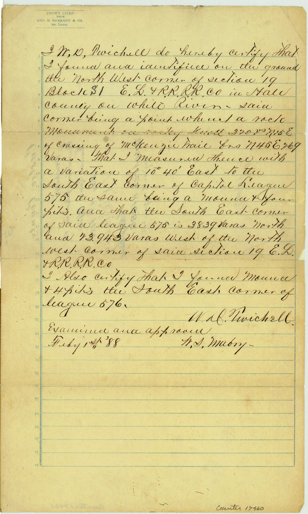
[Twichell's statement on connection from NW corner of section 19, Block S1, E. L. & R. R. R.R. Co. in Hale County to SE corner of Capitol League 575]
-
Map/Doc
17460
-
Collection
General Map Collection
-
Object Dates
1888/2/1 (Creation Date)
1888/5/11 (File Date)
-
People and Organizations
W.D. Twichell (Surveyor/Engineer)
-
Counties
Castro Hale
-
Subjects
Surveying Sketch File
-
Height x Width
14.1 x 8.4 inches
35.8 x 21.3 cm
-
Medium
paper, manuscript
-
Features
White River
McKenzie Trail
Part of: General Map Collection
Andrews County Boundary File 1

Print $133.00
- Digital $50.00
Andrews County Boundary File 1
Size 14.6 x 9.0 inches
Map/Doc 49664
Karnes County Boundary File 4

Print $14.00
- Digital $50.00
Karnes County Boundary File 4
Size 12.7 x 8.2 inches
Map/Doc 55698
Gaines County Rolled Sketch 26

Print $20.00
- Digital $50.00
Gaines County Rolled Sketch 26
1980
Size 28.0 x 15.5 inches
Map/Doc 5940
Garza County Rolled Sketch 6

Print $53.00
- Digital $50.00
Garza County Rolled Sketch 6
Size 43.6 x 30.0 inches
Map/Doc 9052
Nolan County Sketch File 18

Print $8.00
- Digital $50.00
Nolan County Sketch File 18
Size 14.3 x 8.9 inches
Map/Doc 32489
Edwards County Sketch File 11

Print $26.00
- Digital $50.00
Edwards County Sketch File 11
1887
Size 13.7 x 8.8 inches
Map/Doc 21687
Hays County Working Sketch 11

Print $20.00
- Digital $50.00
Hays County Working Sketch 11
1950
Size 22.7 x 33.1 inches
Map/Doc 66085
Freestone County Sketch File 9

Print $4.00
- Digital $50.00
Freestone County Sketch File 9
1859
Size 7.9 x 8.3 inches
Map/Doc 23056
Starr County Working Sketch 1

Print $40.00
- Digital $50.00
Starr County Working Sketch 1
Size 26.7 x 65.5 inches
Map/Doc 63917
Webb County Sketch File 46-1

Print $20.00
- Digital $50.00
Webb County Sketch File 46-1
1939
Size 24.9 x 15.3 inches
Map/Doc 12645
San Augustine County Rolled Sketch 1

Print $20.00
- Digital $50.00
San Augustine County Rolled Sketch 1
1946
Size 19.1 x 30.4 inches
Map/Doc 7553
Lavaca County Working Sketch 12

Print $20.00
- Digital $50.00
Lavaca County Working Sketch 12
1954
Size 17.3 x 32.4 inches
Map/Doc 70365
You may also like
Street guide and metropolitan map of New Orleans [Verso]
![94199, Street guide and metropolitan map of New Orleans [Verso], General Map Collection](https://historictexasmaps.com/wmedia_w700/maps/94199.tif.jpg)
Street guide and metropolitan map of New Orleans [Verso]
1963
Size 18.3 x 27.1 inches
Map/Doc 94199
Borden County Working Sketch 3

Print $20.00
- Digital $50.00
Borden County Working Sketch 3
1944
Size 21.3 x 23.5 inches
Map/Doc 67463
[The S.K. Ry. of Texas, State Line to Pecos, Reeves Co., Texas]
![64161, [The S.K. Ry. of Texas, State Line to Pecos, Reeves Co., Texas], General Map Collection](https://historictexasmaps.com/wmedia_w700/maps/64161.tif.jpg)
Print $40.00
- Digital $50.00
[The S.K. Ry. of Texas, State Line to Pecos, Reeves Co., Texas]
1910
Size 19.2 x 120.9 inches
Map/Doc 64161
University Land Field Notes for Blocks 12, 13, and 14 in Andrews County, and Block 11 in Andrews and Winkler Counties

University Land Field Notes for Blocks 12, 13, and 14 in Andrews County, and Block 11 in Andrews and Winkler Counties
Map/Doc 81711
Texas Gulf Coast Bay Index Map

Print $20.00
- Digital $50.00
Texas Gulf Coast Bay Index Map
Size 43.7 x 42.6 inches
Map/Doc 73599
Controlled Mosaic by Jack Amman Photogrammetric Engineers, Inc - Sheet 15

Print $20.00
- Digital $50.00
Controlled Mosaic by Jack Amman Photogrammetric Engineers, Inc - Sheet 15
1954
Size 20.0 x 24.0 inches
Map/Doc 83459
[St. L. S-W. Ry. of Texas Map of Lufkin Branch in Angelina County, Texas]
![64560, [St. L. S-W. Ry. of Texas Map of Lufkin Branch in Angelina County, Texas], General Map Collection](https://historictexasmaps.com/wmedia_w700/maps/64560-1.tif.jpg)
Print $40.00
- Digital $50.00
[St. L. S-W. Ry. of Texas Map of Lufkin Branch in Angelina County, Texas]
1913
Size 25.7 x 121.3 inches
Map/Doc 64560
Orange County Working Sketch 24

Print $20.00
- Digital $50.00
Orange County Working Sketch 24
1941
Size 12.5 x 14.3 inches
Map/Doc 71356
Donley County Rolled Sketch 3A

Print $20.00
- Digital $50.00
Donley County Rolled Sketch 3A
1946
Size 15.2 x 22.6 inches
Map/Doc 5730
Carte Générale des États-Unis pour servir a l'Histoire de la Louisiane

Print $20.00
- Digital $50.00
Carte Générale des États-Unis pour servir a l'Histoire de la Louisiane
1829
Size 12.0 x 15.9 inches
Map/Doc 97260
Coke County Sketch File 4

Print $46.00
- Digital $50.00
Coke County Sketch File 4
1884
Size 9.2 x 7.7 inches
Map/Doc 18566
Presidio County Working Sketch 83

Print $20.00
- Digital $50.00
Presidio County Working Sketch 83
1969
Size 21.5 x 24.8 inches
Map/Doc 71760