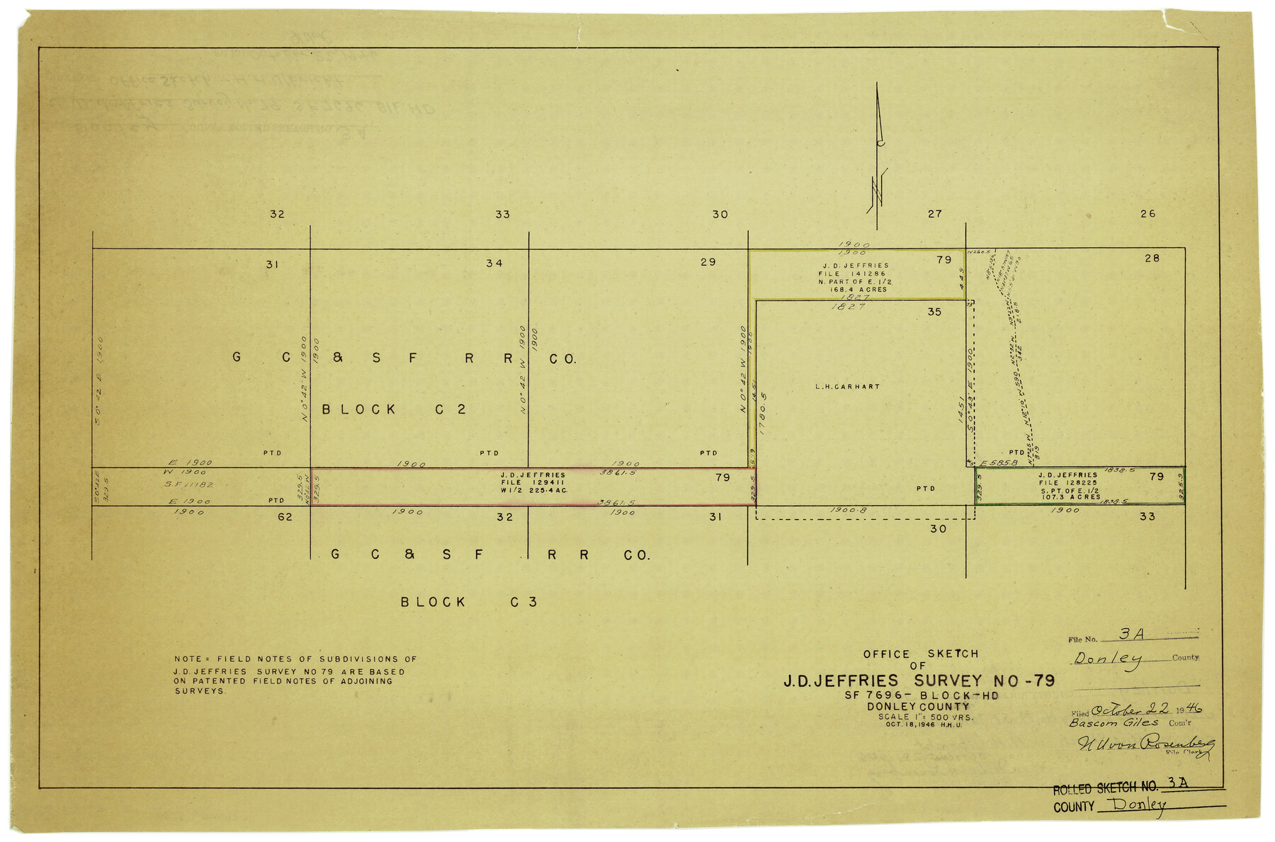
Donley County Rolled Sketch 3A
Office sketch of J.D. Jeffries survey no. 79, SF-7696, Block HD, Donley County
-
Map/Doc
5730
-
Collection
General Map Collection
-
Object Dates
10/18/1946 (Creation Date)
10/22/1946 (File Date)
-
People and Organizations
Herbert H. Ulbricht (Draftsman)
-
Counties
Donley
-
Subjects
Surveying Rolled Sketch
-
Height x Width
15.2 x 22.6 inches
38.6 x 57.4 cm
-
Medium
van dyke/brownline/sepia
-
Scale
1" = 500 varas
Part of: General Map Collection
Flight Mission No. BQR-5K, Frame 73, Brazoria County

Print $20.00
- Digital $50.00
Flight Mission No. BQR-5K, Frame 73, Brazoria County
1952
Size 19.1 x 22.6 inches
Map/Doc 84018
Refugio County Sketch File 23

Print $6.00
- Digital $50.00
Refugio County Sketch File 23
1948
Size 11.2 x 8.7 inches
Map/Doc 35280
Cass County Sketch File 9

Print $4.00
- Digital $50.00
Cass County Sketch File 9
1857
Size 8.0 x 13.1 inches
Map/Doc 17410
Webb County Working Sketch 12

Print $20.00
- Digital $50.00
Webb County Working Sketch 12
1921
Size 15.9 x 14.6 inches
Map/Doc 72377
Henderson County Working Sketch 34

Print $20.00
- Digital $50.00
Henderson County Working Sketch 34
1965
Size 22.9 x 35.8 inches
Map/Doc 66167
Newton County Sketch File O

Print $4.00
- Digital $50.00
Newton County Sketch File O
Size 6.8 x 8.3 inches
Map/Doc 32413
Terrell County Working Sketch 34

Print $20.00
- Digital $50.00
Terrell County Working Sketch 34
1945
Size 26.3 x 37.7 inches
Map/Doc 62126
Map of Comanche County

Print $20.00
- Digital $50.00
Map of Comanche County
1856
Size 22.5 x 29.8 inches
Map/Doc 3432
Fort Bend County Sketch File 3a

Print $6.00
- Digital $50.00
Fort Bend County Sketch File 3a
1874
Size 8.3 x 8.0 inches
Map/Doc 22882
[Surveys in the Bexar District along the Atascosa Creek]
![163, [Surveys in the Bexar District along the Atascosa Creek], General Map Collection](https://historictexasmaps.com/wmedia_w700/maps/163.tif.jpg)
Print $3.00
- Digital $50.00
[Surveys in the Bexar District along the Atascosa Creek]
1847
Size 16.9 x 11.6 inches
Map/Doc 163
Texas Panhandle East Boundary Line

Print $40.00
- Digital $50.00
Texas Panhandle East Boundary Line
Size 66.1 x 9.3 inches
Map/Doc 65380
Nueces County Rolled Sketch 60

Print $40.00
- Digital $50.00
Nueces County Rolled Sketch 60
Size 95.5 x 32.3 inches
Map/Doc 9607
You may also like
[I. M. Bolton, L. S. Thacker, and R. C. Poteet Subdivisions]
![92577, [I. M. Bolton, L. S. Thacker, and R. C. Poteet Subdivisions], Twichell Survey Records](https://historictexasmaps.com/wmedia_w700/maps/92577-1.tif.jpg)
Print $20.00
- Digital $50.00
[I. M. Bolton, L. S. Thacker, and R. C. Poteet Subdivisions]
1924
Size 18.8 x 24.5 inches
Map/Doc 92577
Section P Tech Memorial Park, Inc.

Print $20.00
- Digital $50.00
Section P Tech Memorial Park, Inc.
1953
Size 21.1 x 32.3 inches
Map/Doc 92353
Tyler County Working Sketch 22

Print $20.00
- Digital $50.00
Tyler County Working Sketch 22
1987
Size 42.0 x 35.5 inches
Map/Doc 69492
Leon County Sketch File 11a

Print $4.00
- Digital $50.00
Leon County Sketch File 11a
Size 9.7 x 8.7 inches
Map/Doc 29763
Palo Pinto County Sketch File 27

Print $21.00
- Digital $50.00
Palo Pinto County Sketch File 27
1875
Size 9.8 x 15.7 inches
Map/Doc 33430
Flight Mission No. CUG-1P, Frame 53, Kleberg County

Print $20.00
- Digital $50.00
Flight Mission No. CUG-1P, Frame 53, Kleberg County
1956
Size 18.6 x 22.4 inches
Map/Doc 86131
Bexar County Rolled Sketch 4A

Print $20.00
- Digital $50.00
Bexar County Rolled Sketch 4A
1982
Size 24.4 x 36.7 inches
Map/Doc 5138
Flight Mission No. BRA-3M, Frame 124, Jefferson County

Print $20.00
- Digital $50.00
Flight Mission No. BRA-3M, Frame 124, Jefferson County
1953
Size 18.6 x 21.4 inches
Map/Doc 85398
Live Oak County Sketch File 13

Print $17.00
- Digital $50.00
Live Oak County Sketch File 13
1880
Size 10.2 x 13.7 inches
Map/Doc 30270
Brewster County Rolled Sketch 19B

Print $40.00
- Digital $50.00
Brewster County Rolled Sketch 19B
1881
Size 48.5 x 39.4 inches
Map/Doc 8472
1882 Map of the Texas & Pacific R-Y Reserve

Print $20.00
- Digital $50.00
1882 Map of the Texas & Pacific R-Y Reserve
1887
Size 44.1 x 42.1 inches
Map/Doc 83560
Railroad Track Map, H&TCRRCo., Falls County, Texas

Print $4.00
- Digital $50.00
Railroad Track Map, H&TCRRCo., Falls County, Texas
1918
Size 11.7 x 18.6 inches
Map/Doc 62835