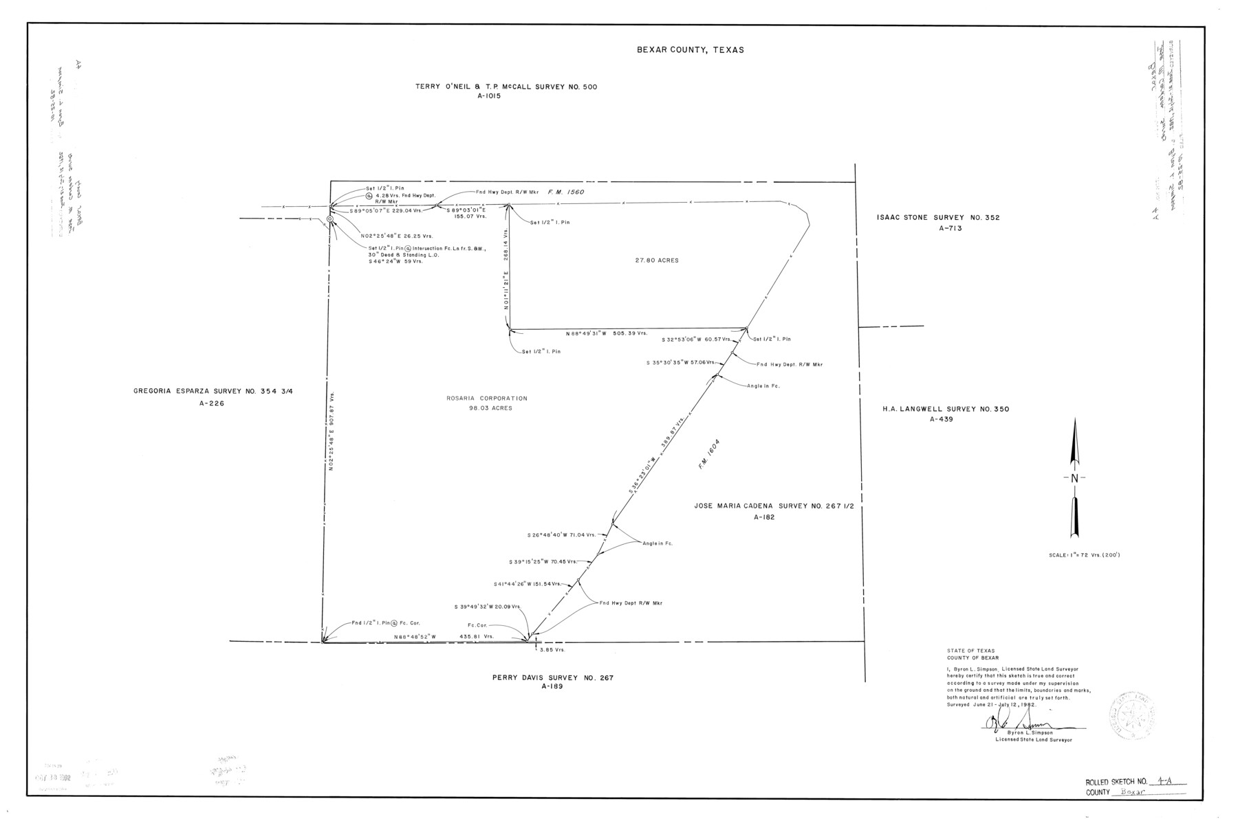
Bexar County Rolled Sketch 4A
[Jose M. Cardena survey]
-
Map/Doc
5138
-
Collection
General Map Collection
-
Object Dates
1982/7/12 (Creation Date)
1982/10/25 (File Date)
-
People and Organizations
Byron L. Simpson (Surveyor/Engineer)
-
Counties
Bexar
-
Subjects
Surveying Rolled Sketch
-
Height x Width
24.4 x 36.7 inches
62.0 x 93.2 cm
-
Medium
mylar, print
-
Scale
1" = 72 varas
-
Comments
See Bexar County Rolled Sketch 4 (5137) and Bexar County Rolled Sketch 4B (5139) for related sketches.
Related maps
Bexar County Rolled Sketch 4

Print $20.00
- Digital $50.00
Bexar County Rolled Sketch 4
Size 24.3 x 36.8 inches
Map/Doc 5137
Bexar County Rolled Sketch 4B

Print $20.00
- Digital $50.00
Bexar County Rolled Sketch 4B
1989
Size 24.3 x 36.7 inches
Map/Doc 5139
Part of: General Map Collection
Childress County Rolled Sketch 3

Print $40.00
- Digital $50.00
Childress County Rolled Sketch 3
Size 21.1 x 57.0 inches
Map/Doc 8598
Lavaca County

Print $40.00
- Digital $50.00
Lavaca County
1946
Size 50.9 x 40.6 inches
Map/Doc 77349
Liberty County Working Sketch 15

Print $20.00
- Digital $50.00
Liberty County Working Sketch 15
1922
Size 19.0 x 15.0 inches
Map/Doc 70474
McLennan County Sketch File 4

Print $4.00
- Digital $50.00
McLennan County Sketch File 4
1852
Size 12.7 x 8.2 inches
Map/Doc 31235
Hamilton County Boundary File 6

Print $4.00
- Digital $50.00
Hamilton County Boundary File 6
Size 11.2 x 8.6 inches
Map/Doc 54225
Lavaca County Sketch File 8

Print $6.00
- Digital $50.00
Lavaca County Sketch File 8
1882
Size 10.7 x 10.3 inches
Map/Doc 29644
Briscoe County Sketch File 14a

Print $6.00
- Digital $50.00
Briscoe County Sketch File 14a
Size 14.3 x 8.6 inches
Map/Doc 16519
Robertson County Working Sketch 5

Print $20.00
- Digital $50.00
Robertson County Working Sketch 5
1980
Size 33.9 x 44.1 inches
Map/Doc 63578
Ector County Sketch File 9

Print $5.00
- Digital $50.00
Ector County Sketch File 9
1939
Size 28.7 x 22.2 inches
Map/Doc 11418
Brooks County Working Sketch 1

Print $3.00
- Digital $50.00
Brooks County Working Sketch 1
Size 9.1 x 9.3 inches
Map/Doc 67785
Motley County Sketch File 7 (N)

Print $20.00
- Digital $50.00
Motley County Sketch File 7 (N)
1901
Size 16.0 x 19.8 inches
Map/Doc 42140
Travis County Rolled Sketch 47

Print $40.00
- Digital $50.00
Travis County Rolled Sketch 47
1928
Size 57.3 x 26.1 inches
Map/Doc 10627
You may also like
Carson County Boundary File 1

Print $8.00
- Digital $50.00
Carson County Boundary File 1
Size 8.8 x 7.4 inches
Map/Doc 51117
Victoria County Sketch File 9

Print $8.00
- Digital $50.00
Victoria County Sketch File 9
1938
Size 14.3 x 8.8 inches
Map/Doc 39530
The Making of America - The Southwest

The Making of America - The Southwest
Size 20.8 x 27.5 inches
Map/Doc 95947
The Republic County of Montgomery. January 21, 1841

Print $20.00
The Republic County of Montgomery. January 21, 1841
2020
Size 19.9 x 21.7 inches
Map/Doc 96238
Copy of Surveyor's Field Book, Morris Browning - In Blocks 7, 5 & 4, I&GNRRCo., Hutchinson and Carson Counties, Texas

Print $2.00
- Digital $50.00
Copy of Surveyor's Field Book, Morris Browning - In Blocks 7, 5 & 4, I&GNRRCo., Hutchinson and Carson Counties, Texas
1888
Size 7.0 x 8.8 inches
Map/Doc 62270
Working Sketch in Bastrop County

Print $20.00
- Digital $50.00
Working Sketch in Bastrop County
1921
Size 14.4 x 22.9 inches
Map/Doc 90205
Brewster County Rolled Sketch 152

Print $20.00
- Digital $50.00
Brewster County Rolled Sketch 152
1996
Size 28.0 x 36.5 inches
Map/Doc 5319
Milam County Working Sketch 15

Print $20.00
- Digital $50.00
Milam County Working Sketch 15
1911
Size 18.2 x 26.1 inches
Map/Doc 71030
Bandera County Working Sketch 58

Print $20.00
- Digital $50.00
Bandera County Working Sketch 58
2001
Size 34.9 x 36.7 inches
Map/Doc 67654
Travis County Sketch File 20

Print $4.00
- Digital $50.00
Travis County Sketch File 20
Size 11.0 x 8.8 inches
Map/Doc 38323
[Sketch showing G. & M. Block 5]
![91704, [Sketch showing G. & M. Block 5], Twichell Survey Records](https://historictexasmaps.com/wmedia_w700/maps/91704-1.tif.jpg)
Print $2.00
- Digital $50.00
[Sketch showing G. & M. Block 5]
Size 7.5 x 5.8 inches
Map/Doc 91704
