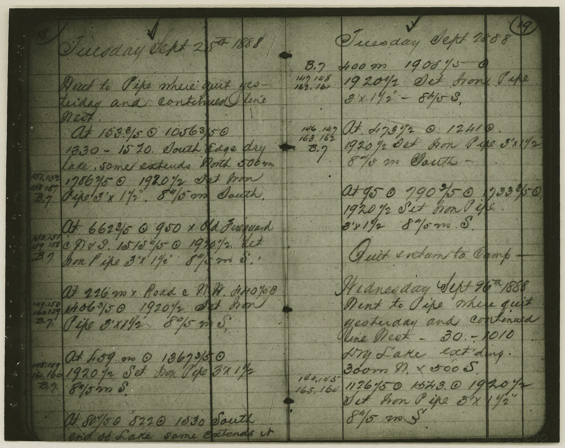
Copy of Surveyor's Field Book, Morris Browning - In Blocks 7, 5 & 4, I&GNRRCo., Hutchinson and Carson Counties, Texas
K-7-70
-
Map/Doc
62270
-
Collection
General Map Collection
-
Object Dates
1888/10/22 (Creation Date)
-
People and Organizations
Morris Browning (Surveyor/Engineer)
-
Counties
Hutchinson Carson
-
Height x Width
7.0 x 8.8 inches
17.8 x 22.4 cm
-
Comments
Copy of Surveyor's field book presented to the General Land Office by Morris Browning on February 3, 1941.
Surveyed from September 14, 1888 to October 22, 1888.
Part of: General Map Collection
No. 1 - Survey for a road from the Brazo Santiago to the Rio Grande

Print $20.00
- Digital $50.00
No. 1 - Survey for a road from the Brazo Santiago to the Rio Grande
1847
Size 18.3 x 27.1 inches
Map/Doc 72876
Hudspeth County Working Sketch 44

Print $20.00
- Digital $50.00
Hudspeth County Working Sketch 44
1982
Size 25.5 x 22.2 inches
Map/Doc 66329
Karnes County

Print $20.00
- Digital $50.00
Karnes County
1921
Size 44.3 x 39.6 inches
Map/Doc 95551
Sutton County Rolled Sketch 38

Print $20.00
- Digital $50.00
Sutton County Rolled Sketch 38
1898
Size 19.6 x 35.1 inches
Map/Doc 7881
Galveston County Sketch File 28

Print $42.00
- Digital $50.00
Galveston County Sketch File 28
1913
Size 22.2 x 5.4 inches
Map/Doc 23410
Galveston to Rio Grande

Print $20.00
- Digital $50.00
Galveston to Rio Grande
1985
Size 45.4 x 37.5 inches
Map/Doc 69958
[Map of the dividing line between Milam and Travis Counties]
![110, [Map of the dividing line between Milam and Travis Counties], General Map Collection](https://historictexasmaps.com/wmedia_w700/maps/110.tif.jpg)
Print $20.00
- Digital $50.00
[Map of the dividing line between Milam and Travis Counties]
1841
Size 14.2 x 12.8 inches
Map/Doc 110
Galveston County NRC Article 33.136 Sketch 87

Print $24.00
- Digital $50.00
Galveston County NRC Article 33.136 Sketch 87
2006
Size 24.0 x 36.0 inches
Map/Doc 95391
Ector County Working Sketch 8

Print $20.00
- Digital $50.00
Ector County Working Sketch 8
1944
Size 40.5 x 26.5 inches
Map/Doc 68851

Crosby County Working Sketch 11

Print $20.00
- Digital $50.00
Crosby County Working Sketch 11
1947
Size 23.7 x 22.8 inches
Map/Doc 68445
Coryell County Working Sketch 11

Print $20.00
- Digital $50.00
Coryell County Working Sketch 11
1949
Size 29.7 x 27.5 inches
Map/Doc 68218
You may also like
[Sketch showing Block M-20, Sections 9 through 46 and Block 22, Sections 1 through 12]
![91717, [Sketch showing Block M-20, Sections 9 through 46 and Block 22, Sections 1 through 12], Twichell Survey Records](https://historictexasmaps.com/wmedia_w700/maps/91717-1.tif.jpg)
Print $3.00
- Digital $50.00
[Sketch showing Block M-20, Sections 9 through 46 and Block 22, Sections 1 through 12]
Size 10.9 x 13.9 inches
Map/Doc 91717
Robertson County Working Sketch 5

Print $20.00
- Digital $50.00
Robertson County Working Sketch 5
1980
Size 33.9 x 44.1 inches
Map/Doc 63578
The Chief Justice County of Washington. Undated

Print $20.00
The Chief Justice County of Washington. Undated
2020
Size 13.0 x 21.7 inches
Map/Doc 96077
Terrell County Rolled Sketch 53

Print $20.00
- Digital $50.00
Terrell County Rolled Sketch 53
Size 33.1 x 24.2 inches
Map/Doc 7971
Hutson Addition to Umbarger, sec. 76, Blk. B-5, Randall Co., Texas

Print $20.00
- Digital $50.00
Hutson Addition to Umbarger, sec. 76, Blk. B-5, Randall Co., Texas
Size 30.5 x 29.5 inches
Map/Doc 92155

Starr County Sketch File 6

Print $20.00
- Digital $50.00
Starr County Sketch File 6
Size 43.4 x 36.7 inches
Map/Doc 10605
Kerr County Sketch File 11

Print $4.00
- Digital $50.00
Kerr County Sketch File 11
1889
Size 14.2 x 8.7 inches
Map/Doc 28879
Crockett County Sketch File 47

Print $6.00
- Digital $50.00
Crockett County Sketch File 47
1882
Size 14.3 x 8.8 inches
Map/Doc 19789
Val Verde County Rolled Sketch 85

Print $20.00
- Digital $50.00
Val Verde County Rolled Sketch 85
2009
Size 25.4 x 38.0 inches
Map/Doc 89234
Anderson County Working Sketch 38

Print $20.00
- Digital $50.00
Anderson County Working Sketch 38
1985
Size 43.3 x 45.9 inches
Map/Doc 67038
Aransas County Working Sketch 6

Print $20.00
- Digital $50.00
Aransas County Working Sketch 6
1943
Size 26.0 x 35.5 inches
Map/Doc 67173