Brewster County Rolled Sketch 19B
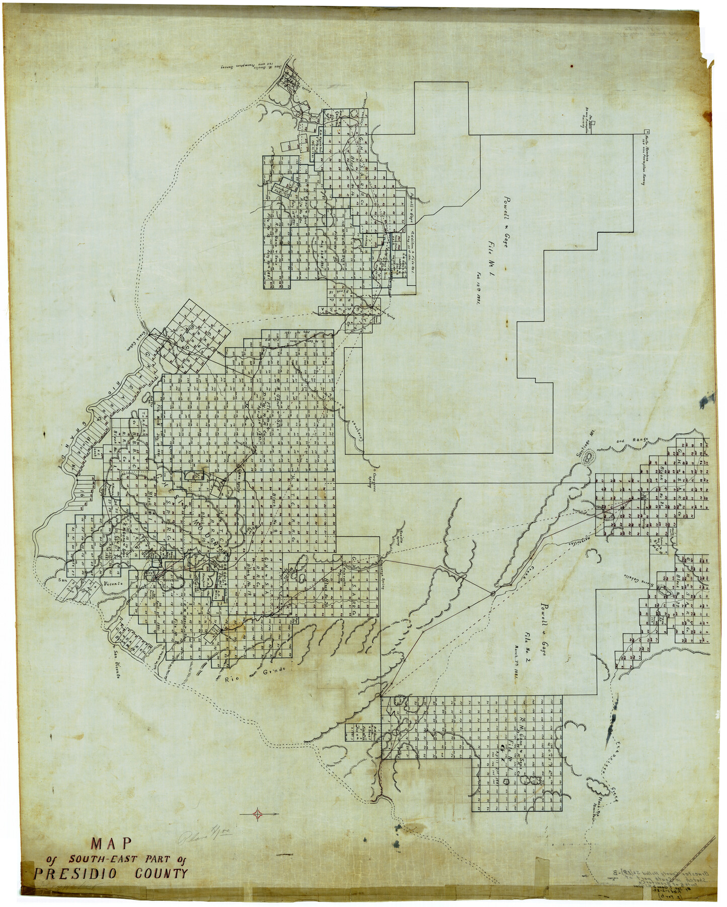
Map of South-east part of Presidio County showing the locations made by R.M. Gano & Sons, together with connecting and adjoining surveys
-
Map/Doc
8472
-
Collection
General Map Collection
-
Object Dates
7/1881 (Creation Date)
1/2/1882 (File Date)
-
People and Organizations
E.G. Gleim (Surveyor/Engineer)
Jno. T. Gano (Surveyor/Engineer)
Jefferson Haskell (Chainman/Field Personnel)
Leslie Gadd (Chainman/Field Personnel)
Edward Kennedy (Chainman/Field Personnel)
-
Counties
Brewster
-
Subjects
Surveying Rolled Sketch
-
Height x Width
48.5 x 39.4 inches
123.2 x 100.1 cm
-
Medium
linen, manuscript
-
Scale
1" = 4000 varas
-
Comments
See Brewster County Rolled Sketch 19A (8471) for bottom half of this sketch.
Related maps
Brewster County Rolled Sketch 19A

Print $20.00
- Digital $50.00
Brewster County Rolled Sketch 19A
1881
Size 31.5 x 38.6 inches
Map/Doc 8471
Part of: General Map Collection
Harris County Sketch File 86

Print $20.00
- Digital $50.00
Harris County Sketch File 86
1894
Size 34.7 x 21.3 inches
Map/Doc 11674
Angelina County Working Sketch Graphic Index

Print $40.00
- Digital $50.00
Angelina County Working Sketch Graphic Index
1945
Size 37.4 x 48.3 inches
Map/Doc 76454
Refugio County Sketch File 27

Print $18.00
- Digital $50.00
Refugio County Sketch File 27
1993
Size 11.4 x 8.8 inches
Map/Doc 35294
El Paso County Working Sketch 53

Print $20.00
- Digital $50.00
El Paso County Working Sketch 53
1992
Size 22.8 x 28.9 inches
Map/Doc 69075
Flight Mission No. DQO-2K, Frame 165, Galveston County

Print $20.00
- Digital $50.00
Flight Mission No. DQO-2K, Frame 165, Galveston County
1952
Size 18.9 x 22.4 inches
Map/Doc 85054
Eastland County Working Sketch 45

Print $20.00
- Digital $50.00
Eastland County Working Sketch 45
1979
Size 31.3 x 43.7 inches
Map/Doc 68826
Hutchinson County Boundary File 4

Print $17.00
- Digital $50.00
Hutchinson County Boundary File 4
Size 14.3 x 8.7 inches
Map/Doc 55305
Hays County Rolled Sketch 26

Print $20.00
- Digital $50.00
Hays County Rolled Sketch 26
1943
Size 27.7 x 25.6 inches
Map/Doc 6182
Flight Mission No. DIX-8P, Frame 94, Aransas County

Print $20.00
- Digital $50.00
Flight Mission No. DIX-8P, Frame 94, Aransas County
1956
Size 18.5 x 22.3 inches
Map/Doc 83919
Uvalde County Working Sketch 47

Print $20.00
- Digital $50.00
Uvalde County Working Sketch 47
1979
Size 29.7 x 24.8 inches
Map/Doc 72117
Kimble County

Print $40.00
- Digital $50.00
Kimble County
1930
Size 41.0 x 49.0 inches
Map/Doc 77340
Martin County Sketch File 13

Print $4.00
- Digital $50.00
Martin County Sketch File 13
1941
Size 14.2 x 9.1 inches
Map/Doc 30669
You may also like
Flight Mission No. BRE-2P, Frame 15, Nueces County

Print $20.00
- Digital $50.00
Flight Mission No. BRE-2P, Frame 15, Nueces County
1956
Size 18.4 x 22.4 inches
Map/Doc 86724
Floyd County Rolled Sketch 5

Print $20.00
- Digital $50.00
Floyd County Rolled Sketch 5
1892
Size 27.2 x 18.7 inches
Map/Doc 5880
[Southern Part of County]
![91905, [Southern Part of County], Twichell Survey Records](https://historictexasmaps.com/wmedia_w700/maps/91905-1.tif.jpg)
Print $2.00
- Digital $50.00
[Southern Part of County]
Size 9.8 x 7.6 inches
Map/Doc 91905
Coast Chart No. 210 - Aransas Pass and Corpus Christi Bay with the coast to latitude 27° 12', Texas

Print $20.00
- Digital $50.00
Coast Chart No. 210 - Aransas Pass and Corpus Christi Bay with the coast to latitude 27° 12', Texas
1887
Size 30.4 x 24.0 inches
Map/Doc 73444
Colorado County Working Sketch 9

Print $20.00
- Digital $50.00
Colorado County Working Sketch 9
1939
Size 12.0 x 15.7 inches
Map/Doc 68109
Flight Mission No. DQN-2K, Frame 115, Calhoun County

Print $20.00
- Digital $50.00
Flight Mission No. DQN-2K, Frame 115, Calhoun County
1953
Size 18.6 x 22.3 inches
Map/Doc 84291
Navarro County Sketch File 8

Print $4.00
- Digital $50.00
Navarro County Sketch File 8
1849
Size 13.2 x 8.5 inches
Map/Doc 32315
Lynn County Sketch File 20

Print $4.00
- Digital $50.00
Lynn County Sketch File 20
1891
Size 8.8 x 10.9 inches
Map/Doc 30527
Calhoun County Working Sketch 6

Print $20.00
- Digital $50.00
Calhoun County Working Sketch 6
1943
Size 20.8 x 24.1 inches
Map/Doc 67822
Brewster County Rolled Sketch B

Print $40.00
- Digital $50.00
Brewster County Rolled Sketch B
1882
Size 67.4 x 37.7 inches
Map/Doc 8465
Bastrop County Working Sketch 8

Print $20.00
- Digital $50.00
Bastrop County Working Sketch 8
1937
Size 23.9 x 43.1 inches
Map/Doc 67308
Angelina County Sketch File 15d

Print $20.00
- Digital $50.00
Angelina County Sketch File 15d
1863
Size 8.0 x 6.6 inches
Map/Doc 12980