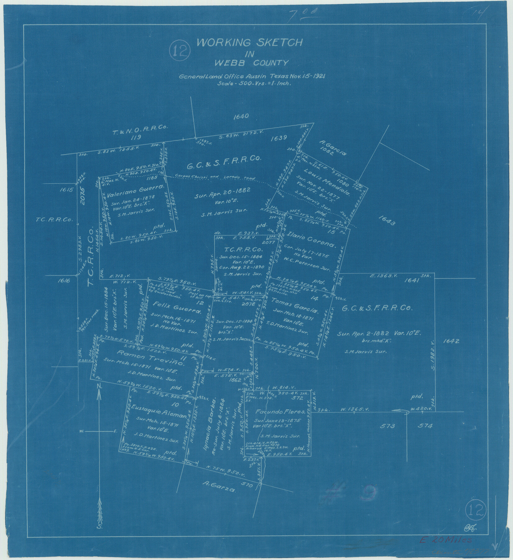
Webb County Working Sketch 12
-
Map/Doc
72377
-
Collection
General Map Collection
-
Object Dates
11/15/1921 (Creation Date)
-
Counties
Webb
-
Subjects
Surveying Working Sketch
-
Height x Width
15.9 x 14.6 inches
40.4 x 37.1 cm
-
Scale
1" = 500 varas
Part of: General Map Collection
King County Working Sketch 14

Print $20.00
- Digital $50.00
King County Working Sketch 14
1979
Size 27.7 x 32.5 inches
Map/Doc 70178
Brewster County Working Sketch 107

Print $20.00
- Digital $50.00
Brewster County Working Sketch 107
1981
Size 34.7 x 37.1 inches
Map/Doc 67707
Live Oak County Sketch File 35

Print $12.00
- Digital $50.00
Live Oak County Sketch File 35
1969
Size 11.0 x 8.7 inches
Map/Doc 30339
Culberson County Working Sketch 66

Print $40.00
- Digital $50.00
Culberson County Working Sketch 66
1975
Size 52.1 x 33.2 inches
Map/Doc 68520
Flight Mission No. DQN-4K, Frame 2, Calhoun County

Print $20.00
- Digital $50.00
Flight Mission No. DQN-4K, Frame 2, Calhoun County
1953
Size 18.6 x 22.2 inches
Map/Doc 84367
Hidalgo County Working Sketch 9

Print $20.00
- Digital $50.00
Hidalgo County Working Sketch 9
1984
Size 27.2 x 15.0 inches
Map/Doc 66186
Clay County Working Sketch 13

Print $20.00
- Digital $50.00
Clay County Working Sketch 13
1955
Size 14.7 x 14.3 inches
Map/Doc 68036
Right of Way and Track Map of The Missouri, Kansas & Texas Railway of Texas

Print $40.00
- Digital $50.00
Right of Way and Track Map of The Missouri, Kansas & Texas Railway of Texas
1918
Size 24.9 x 53.1 inches
Map/Doc 64537
Flight Mission No. DQO-2K, Frame 89, Galveston County

Print $20.00
- Digital $50.00
Flight Mission No. DQO-2K, Frame 89, Galveston County
1952
Size 18.6 x 22.3 inches
Map/Doc 85016
Cass County Working Sketch 4

Print $20.00
- Digital $50.00
Cass County Working Sketch 4
1936
Size 33.7 x 29.1 inches
Map/Doc 67907
Flight Mission No. CGI-1N, Frame 176, Cameron County

Print $20.00
- Digital $50.00
Flight Mission No. CGI-1N, Frame 176, Cameron County
1955
Size 18.5 x 22.2 inches
Map/Doc 84511
Bosque County Rolled Sketch 2

Print $20.00
- Digital $50.00
Bosque County Rolled Sketch 2
Size 30.2 x 18.1 inches
Map/Doc 5160
You may also like
Karnes County Sketch File 11

Print $4.00
- Digital $50.00
Karnes County Sketch File 11
1885
Size 10.5 x 8.1 inches
Map/Doc 28602
Dickens County Rolled Sketch P1

Print $20.00
- Digital $50.00
Dickens County Rolled Sketch P1
1915
Size 40.5 x 36.2 inches
Map/Doc 8783
Jefferson County NRC Article 33.136 Sketch 4

Print $2.00
- Digital $50.00
Jefferson County NRC Article 33.136 Sketch 4
2004
Size 14.5 x 8.4 inches
Map/Doc 82993
El Paso County Working Sketch 50

Print $20.00
- Digital $50.00
El Paso County Working Sketch 50
1991
Size 25.9 x 27.7 inches
Map/Doc 69072
Segunda parte del Mapa, que comprende la Frontera, de los Dominios del Rey, en la America Septentrional

Print $40.00
- Digital $50.00
Segunda parte del Mapa, que comprende la Frontera, de los Dominios del Rey, en la America Septentrional
1769
Size 26.7 x 63.8 inches
Map/Doc 4667
Runnels County Sketch File 19 and 22

Print $48.00
Runnels County Sketch File 19 and 22
1887
Size 14.0 x 21.2 inches
Map/Doc 12254
McMullen County Sketch File 40

Print $6.00
- Digital $50.00
McMullen County Sketch File 40
1939
Size 14.2 x 8.7 inches
Map/Doc 31415
The Chief Justice County of Brazoria. Lands in Conflict with Colorado, Harrisburg, Matagorda Counties

Print $20.00
The Chief Justice County of Brazoria. Lands in Conflict with Colorado, Harrisburg, Matagorda Counties
2020
Size 14.8 x 21.7 inches
Map/Doc 96043
Harrison County Working Sketch 28

Print $20.00
- Digital $50.00
Harrison County Working Sketch 28
1992
Size 17.0 x 17.0 inches
Map/Doc 66048
Hutchinson County Working Sketch 25

Print $20.00
- Digital $50.00
Hutchinson County Working Sketch 25
1972
Size 21.5 x 25.0 inches
Map/Doc 66385
Flight Mission No. BRE-2P, Frame 12, Nueces County

Print $20.00
- Digital $50.00
Flight Mission No. BRE-2P, Frame 12, Nueces County
1956
Size 18.5 x 22.6 inches
Map/Doc 86721
Brazos River, Brazos River Sheet 7

Print $6.00
- Digital $50.00
Brazos River, Brazos River Sheet 7
1926
Size 24.1 x 30.6 inches
Map/Doc 65300