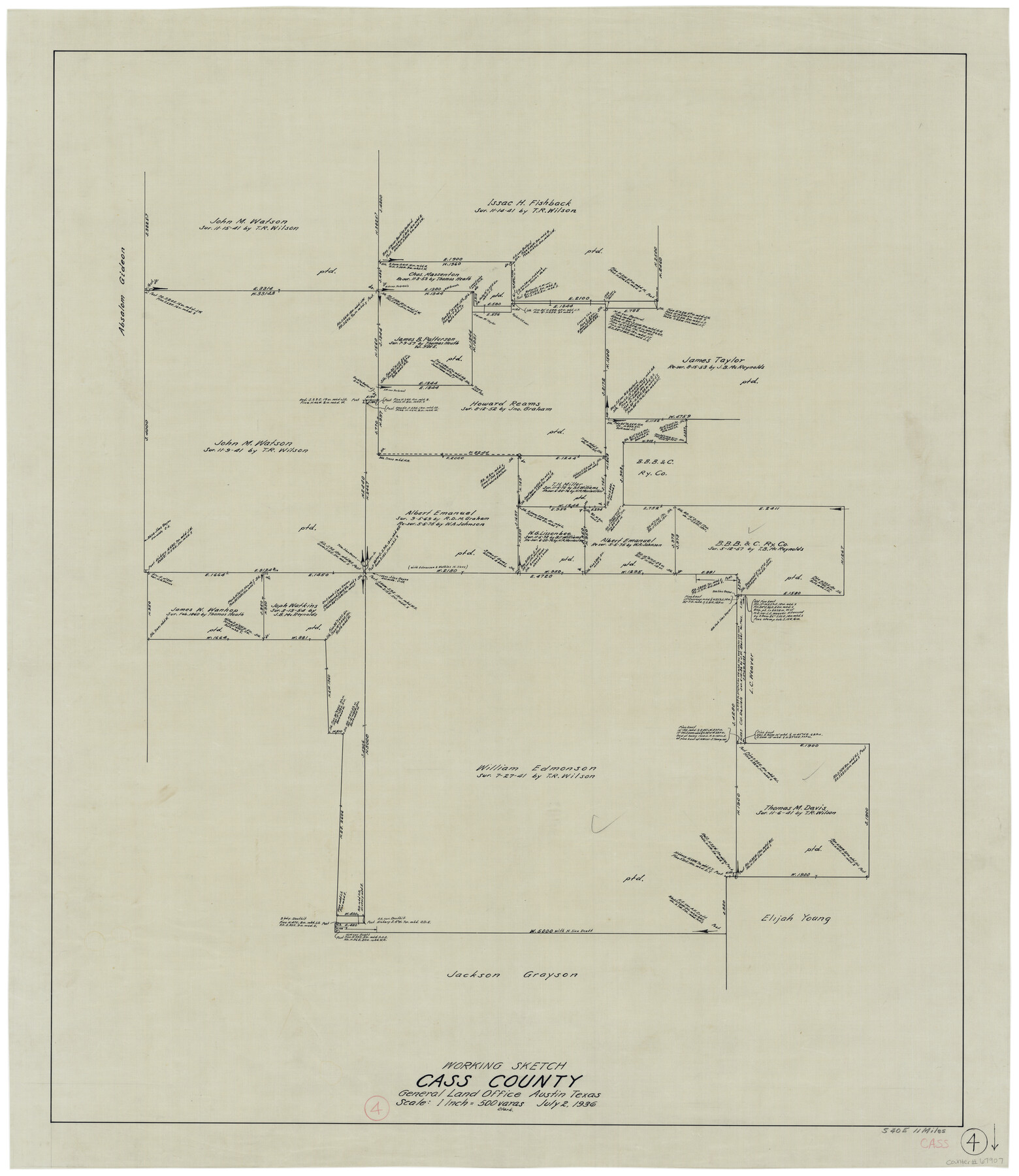
Cass County Working Sketch 4
-
Map/Doc
67907
-
Collection
General Map Collection
-
Object Dates
7/2/1936 (Creation Date)
-
Counties
Cass
-
Subjects
Surveying Working Sketch
-
Height x Width
33.7 x 29.1 inches
85.6 x 73.9 cm
-
Scale
1" = 500 varas
Part of: General Map Collection
Crockett County Rolled Sketch 42A

Print $20.00
- Digital $50.00
Crockett County Rolled Sketch 42A
Size 20.3 x 24.4 inches
Map/Doc 5593
Coke County Rolled Sketch 12A

Print $20.00
- Digital $50.00
Coke County Rolled Sketch 12A
1949
Size 21.1 x 23.4 inches
Map/Doc 5513
Hardin County Working Sketch 27

Print $20.00
- Digital $50.00
Hardin County Working Sketch 27
1954
Size 22.9 x 27.9 inches
Map/Doc 63425
Webb County Working Sketch 18

Print $20.00
- Digital $50.00
Webb County Working Sketch 18
1923
Size 18.6 x 12.8 inches
Map/Doc 72383
Flight Mission No. CUG-2P, Frame 66, Kleberg County

Print $20.00
- Digital $50.00
Flight Mission No. CUG-2P, Frame 66, Kleberg County
1956
Size 18.5 x 22.2 inches
Map/Doc 86203
Map of Comanche County

Print $20.00
- Digital $50.00
Map of Comanche County
1884
Size 20.9 x 26.5 inches
Map/Doc 3434
Nacogdoches County Sketch File 20

Print $26.00
- Digital $50.00
Nacogdoches County Sketch File 20
Size 12.6 x 7.9 inches
Map/Doc 32275
Burleson County Working Sketch Graphic Index

Print $20.00
- Digital $50.00
Burleson County Working Sketch Graphic Index
1978
Size 35.0 x 46.1 inches
Map/Doc 76481
Presidio County Rolled Sketch 138

Print $20.00
- Digital $50.00
Presidio County Rolled Sketch 138
2000
Size 36.7 x 25.1 inches
Map/Doc 7405
Lampasas County Sketch File 11

Print $4.00
- Digital $50.00
Lampasas County Sketch File 11
1874
Size 12.2 x 7.9 inches
Map/Doc 29420
Map of section no. 7 of a survey of Padre Island made for the Office of the Attorney General of the State of Texas

Print $40.00
- Digital $50.00
Map of section no. 7 of a survey of Padre Island made for the Office of the Attorney General of the State of Texas
1941
Size 56.3 x 41.2 inches
Map/Doc 2263
Brewster County Rolled Sketch A

Print $40.00
- Digital $50.00
Brewster County Rolled Sketch A
Size 26.7 x 94.8 inches
Map/Doc 8925
You may also like
Donley County Working Sketch 6

Print $20.00
- Digital $50.00
Donley County Working Sketch 6
1965
Size 34.3 x 42.2 inches
Map/Doc 68739
Portion of States Submerged Area in Matagorda Bay

Print $20.00
- Digital $50.00
Portion of States Submerged Area in Matagorda Bay
1923
Size 12.7 x 13.5 inches
Map/Doc 2956
Presidio County Rolled Sketch T-2

Print $40.00
- Digital $50.00
Presidio County Rolled Sketch T-2
Size 29.9 x 65.1 inches
Map/Doc 9804
Flight Mission No. DQO-1K, Frame 149, Galveston County

Print $20.00
- Digital $50.00
Flight Mission No. DQO-1K, Frame 149, Galveston County
1952
Size 19.0 x 22.8 inches
Map/Doc 85002

Webb County Rolled Sketch 41

Print $20.00
- Digital $50.00
Webb County Rolled Sketch 41
1941
Size 25.0 x 18.0 inches
Map/Doc 8196
Flight Mission No. DQN-3K, Frame 50, Calhoun County

Print $20.00
- Digital $50.00
Flight Mission No. DQN-3K, Frame 50, Calhoun County
1953
Size 18.4 x 22.2 inches
Map/Doc 84351
Yoakum County Sketch File 10

Print $20.00
- Digital $50.00
Yoakum County Sketch File 10
1902
Size 33.7 x 18.8 inches
Map/Doc 12706
Flight Mission No. CRE-2R, Frame 161, Jackson County

Print $20.00
- Digital $50.00
Flight Mission No. CRE-2R, Frame 161, Jackson County
1956
Size 18.5 x 22.1 inches
Map/Doc 85372
Trinity County Rolled Sketch 4

Print $20.00
- Digital $50.00
Trinity County Rolled Sketch 4
1948
Size 38.5 x 42.4 inches
Map/Doc 10026
Liberty County Rolled Sketch 15

Print $20.00
- Digital $50.00
Liberty County Rolled Sketch 15
2015
Size 36.2 x 24.5 inches
Map/Doc 94024
Atascosa County Working Sketch 32

Print $20.00
- Digital $50.00
Atascosa County Working Sketch 32
1981
Size 12.9 x 11.8 inches
Map/Doc 67228