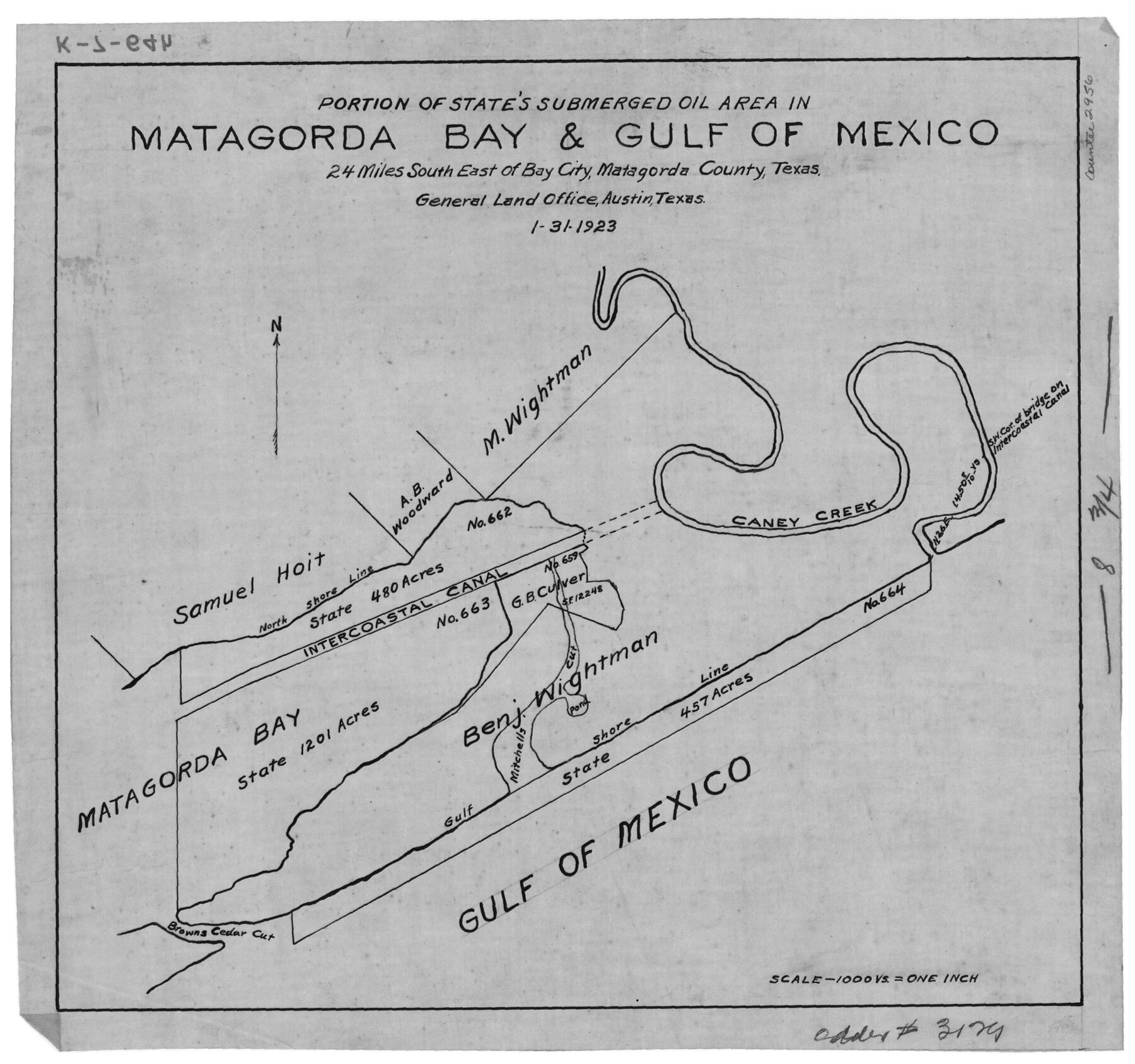
Portion of States Submerged Area in Matagorda Bay
K-7-64 (a-h)
-
Map/Doc
2956
-
Collection
General Map Collection
-
Object Dates
1/31/1923 (Creation Date)
-
Counties
Matagorda
-
Subjects
Energy Offshore Submerged Area
-
Height x Width
12.7 x 13.5 inches
32.3 x 34.3 cm
Part of: General Map Collection
Hutchinson County Rolled Sketch 43

Print $40.00
- Digital $50.00
Hutchinson County Rolled Sketch 43
1992
Size 38.0 x 49.4 inches
Map/Doc 6311
Chart of the Harbour of San [Luis]
![72761, Chart of the Harbour of San [Luis], General Map Collection](https://historictexasmaps.com/wmedia_w700/maps/72761.tif.jpg)
Print $20.00
- Digital $50.00
Chart of the Harbour of San [Luis]
1846
Size 27.3 x 18.3 inches
Map/Doc 72761
Edwards County Sketch File 17

Print $20.00
- Digital $50.00
Edwards County Sketch File 17
Size 31.8 x 18.3 inches
Map/Doc 11429
Clay County Working Sketch 14

Print $20.00
- Digital $50.00
Clay County Working Sketch 14
1984
Size 46.9 x 34.5 inches
Map/Doc 68037
Cottle County Sketch File 18

Print $46.00
- Digital $50.00
Cottle County Sketch File 18
2004
Size 8.0 x 11.0 inches
Map/Doc 82433
Parker County Sketch File 1a

Print $2.00
- Digital $50.00
Parker County Sketch File 1a
1859
Size 8.6 x 5.5 inches
Map/Doc 33518
Jeff Davis County Working Sketch 36

Print $20.00
- Digital $50.00
Jeff Davis County Working Sketch 36
1979
Size 37.2 x 28.8 inches
Map/Doc 66531
Newton County Working Sketch 6

Print $20.00
- Digital $50.00
Newton County Working Sketch 6
1930
Size 35.5 x 25.9 inches
Map/Doc 71252
Map of Swisher County

Print $40.00
- Digital $50.00
Map of Swisher County
1900
Size 48.5 x 41.1 inches
Map/Doc 16890
Donley County Sketch File 11

Print $8.00
- Digital $50.00
Donley County Sketch File 11
1892
Size 14.6 x 8.3 inches
Map/Doc 21244
Hudspeth County Sketch File 53

Print $6.00
- Digital $50.00
Hudspeth County Sketch File 53
1993
Size 14.3 x 8.9 inches
Map/Doc 27076
Map of Montague County

Print $20.00
- Digital $50.00
Map of Montague County
1858
Size 28.6 x 20.5 inches
Map/Doc 3886
You may also like
Young County Working Sketch 9

Print $20.00
- Digital $50.00
Young County Working Sketch 9
1921
Size 25.9 x 36.6 inches
Map/Doc 62032


[Surveys in the Bexar and San Patricio Districts along the Nueces and Frio Rivers]
![36, [Surveys in the Bexar and San Patricio Districts along the Nueces and Frio Rivers], General Map Collection](https://historictexasmaps.com/wmedia_w700/maps/36.tif.jpg)
Print $20.00
- Digital $50.00
[Surveys in the Bexar and San Patricio Districts along the Nueces and Frio Rivers]
1830
Size 21.5 x 27.3 inches
Map/Doc 36
Walker County Working Sketch 12

Print $20.00
- Digital $50.00
Walker County Working Sketch 12
1943
Size 23.1 x 32.9 inches
Map/Doc 72292
City of Aransas Pass and Chart of Aransas Bay and Corpus Christi Bay, Texas

Print $20.00
- Digital $50.00
City of Aransas Pass and Chart of Aransas Bay and Corpus Christi Bay, Texas
1905
Size 28.4 x 21.4 inches
Map/Doc 97265
Kimble County Sketch File 3

Print $4.00
- Digital $50.00
Kimble County Sketch File 3
1847
Size 9.1 x 11.5 inches
Map/Doc 28910
Somervell County Rolled Sketch C

Print $3.00
- Digital $50.00
Somervell County Rolled Sketch C
Size 9.0 x 13.4 inches
Map/Doc 7793
Dallas County Rolled Sketch 4A

Print $20.00
- Digital $50.00
Dallas County Rolled Sketch 4A
1954
Size 12.5 x 23.1 inches
Map/Doc 5688
Brewster County Rolled Sketch 147

Print $20.00
- Digital $50.00
Brewster County Rolled Sketch 147
1986
Size 24.6 x 24.8 inches
Map/Doc 5313
Kleberg County Boundary File 2c

Print $40.00
- Digital $50.00
Kleberg County Boundary File 2c
Size 8.8 x 49.6 inches
Map/Doc 64979
Shelby County Working Sketch 27

Print $20.00
- Digital $50.00
Shelby County Working Sketch 27
1995
Size 32.8 x 39.9 inches
Map/Doc 63881