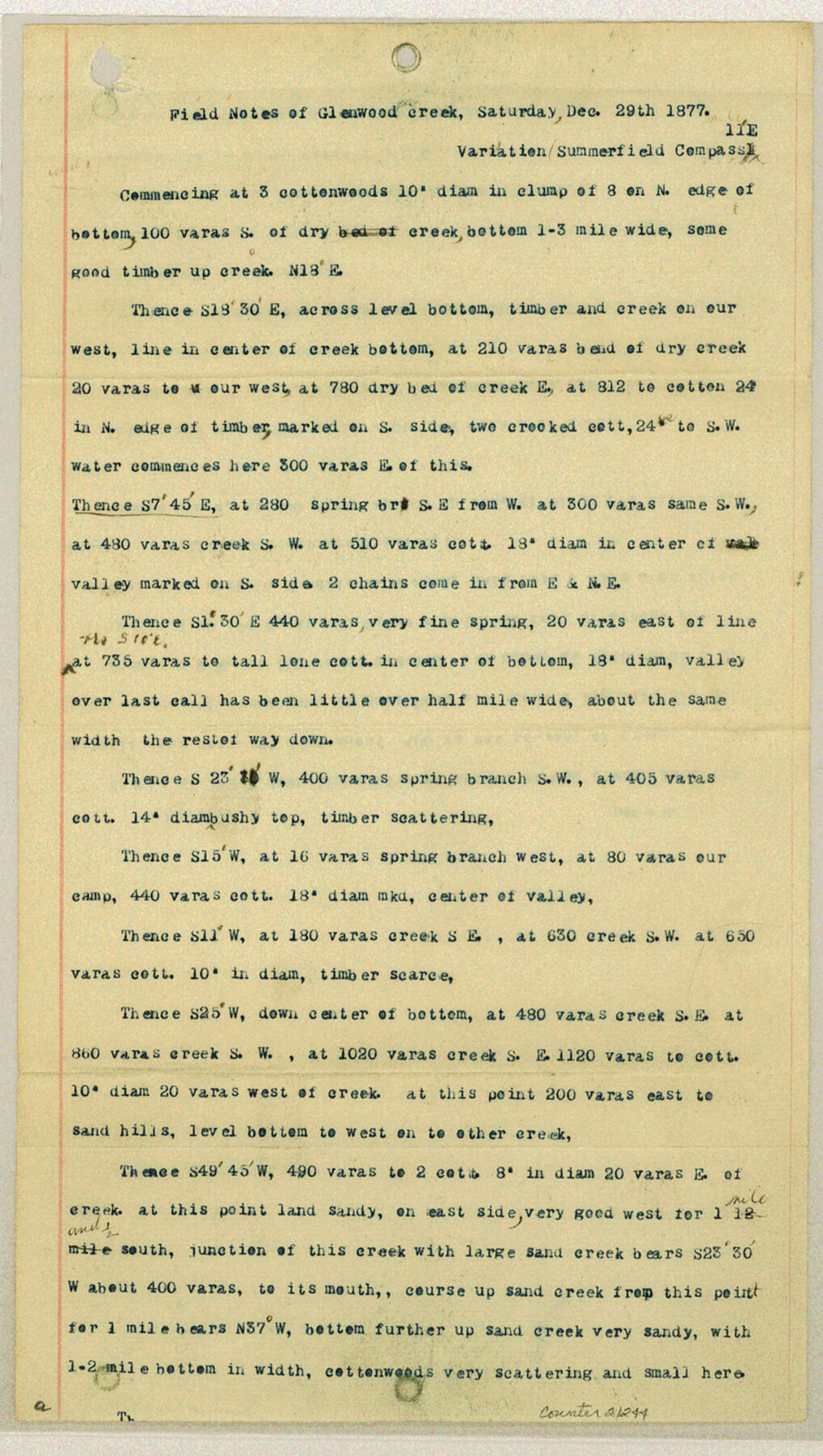
Donley County Sketch File 11
[Field notes of Glenwood Creek]
-
Map/Doc
21244
-
Collection
General Map Collection
-
Object Dates
1892/2/16 (Creation Date)
1877/12/29 (Survey Date)
-
People and Organizations
John Summerfield (Surveyor/Engineer)
-
Counties
Donley
-
Subjects
Surveying Sketch File
-
Height x Width
14.6 x 8.3 inches
37.1 x 21.1 cm
-
Medium
paper, print
-
Features
Glenwood Creek
Salt Fork of Red River
Sandy Creek
Part of: General Map Collection
San Patricio County NRC Article 33.136 Sketch 6

Print $24.00
- Digital $50.00
San Patricio County NRC Article 33.136 Sketch 6
2010
Size 22.0 x 34.0 inches
Map/Doc 94472
Calhoun County Rolled Sketch 29A

Print $20.00
- Digital $50.00
Calhoun County Rolled Sketch 29A
Size 30.4 x 33.5 inches
Map/Doc 8557
Gray County Sketch File 8

Print $20.00
- Digital $50.00
Gray County Sketch File 8
1888
Size 17.7 x 20.7 inches
Map/Doc 11577
Flight Mission No. DQO-7K, Frame 75, Galveston County

Print $20.00
- Digital $50.00
Flight Mission No. DQO-7K, Frame 75, Galveston County
1952
Size 18.9 x 22.4 inches
Map/Doc 85102
Chambers County Working Sketch 10

Print $20.00
- Digital $50.00
Chambers County Working Sketch 10
1950
Size 40.1 x 33.0 inches
Map/Doc 67993
Jefferson County Sketch File 39

Print $20.00
- Digital $50.00
Jefferson County Sketch File 39
Size 14.3 x 8.7 inches
Map/Doc 28218
Flight Mission No. CGI-4N, Frame 158, Cameron County

Print $20.00
- Digital $50.00
Flight Mission No. CGI-4N, Frame 158, Cameron County
1955
Size 18.5 x 22.2 inches
Map/Doc 84666
Terrell County Working Sketch 37

Print $20.00
- Digital $50.00
Terrell County Working Sketch 37
1950
Size 24.5 x 24.1 inches
Map/Doc 62130
Edwards County Working Sketch 36

Print $20.00
- Digital $50.00
Edwards County Working Sketch 36
1948
Size 46.7 x 44.5 inches
Map/Doc 68912
Lubbock County Boundary File 1

Print $64.00
- Digital $50.00
Lubbock County Boundary File 1
Size 8.8 x 8.6 inches
Map/Doc 56455
Map of the Texas & Pacific Ry. Reserve West of the Pecos River

Print $20.00
- Digital $50.00
Map of the Texas & Pacific Ry. Reserve West of the Pecos River
1879
Size 41.2 x 29.9 inches
Map/Doc 65334
El Paso County Working Sketch 36

Print $20.00
- Digital $50.00
El Paso County Working Sketch 36
1983
Size 34.0 x 40.3 inches
Map/Doc 69058
You may also like
Flight Mission No. DAG-28K, Frame 32, Matagorda County

Print $20.00
- Digital $50.00
Flight Mission No. DAG-28K, Frame 32, Matagorda County
1953
Size 16.2 x 16.0 inches
Map/Doc 86600
Texas State Boundary Line 5

Print $48.00
- Digital $50.00
Texas State Boundary Line 5
1907
Size 12.4 x 21.1 inches
Map/Doc 74959
Hutchinson County Sketch File 30

Print $6.00
- Digital $50.00
Hutchinson County Sketch File 30
1927
Size 11.2 x 8.8 inches
Map/Doc 27264
[PSL Block A-12]
![93229, [PSL Block A-12], Twichell Survey Records](https://historictexasmaps.com/wmedia_w700/maps/93229-1.tif.jpg)
Print $2.00
- Digital $50.00
[PSL Block A-12]
1953
Size 8.7 x 13.5 inches
Map/Doc 93229
[Surveying Sketch of John Poitevent Block 1, Railroad Lands, et al in Knox County, Texas]
![414, [Surveying Sketch of John Poitevent Block 1, Railroad Lands, et al in Knox County, Texas], Maddox Collection](https://historictexasmaps.com/wmedia_w700/maps/0414.tif.jpg)
Print $3.00
- Digital $50.00
[Surveying Sketch of John Poitevent Block 1, Railroad Lands, et al in Knox County, Texas]
Size 11.9 x 14.2 inches
Map/Doc 414
The Republic County of Nacogdoches. Proposed, Late Fall 1837

Print $20.00
The Republic County of Nacogdoches. Proposed, Late Fall 1837
2020
Size 17.5 x 21.7 inches
Map/Doc 96242
Harris County Working Sketch 95

Print $20.00
- Digital $50.00
Harris County Working Sketch 95
1978
Size 26.6 x 44.1 inches
Map/Doc 65987
Natural Heritage of Texas

Print $40.00
- Digital $50.00
Natural Heritage of Texas
1986
Size 54.3 x 56.0 inches
Map/Doc 10786
Williamson County Rolled Sketch 11

Print $20.00
- Digital $50.00
Williamson County Rolled Sketch 11
Size 37.5 x 28.4 inches
Map/Doc 8268
Flight Mission No. DCL-6C, Frame 115, Kenedy County

Print $20.00
- Digital $50.00
Flight Mission No. DCL-6C, Frame 115, Kenedy County
1943
Size 18.5 x 22.4 inches
Map/Doc 85945
Copy of Surveyor's Field Book, Morris Browning - In Blocks 7, 5 & 4, I&GNRRCo., Hutchinson and Carson Counties, Texas

Print $3.00
- Digital $50.00
Copy of Surveyor's Field Book, Morris Browning - In Blocks 7, 5 & 4, I&GNRRCo., Hutchinson and Carson Counties, Texas
1888
Size 12.7 x 9.7 inches
Map/Doc 62258
Located Line of the Panhandle & Gulf Ry. through State Lands

Print $40.00
- Digital $50.00
Located Line of the Panhandle & Gulf Ry. through State Lands
1904
Size 12.4 x 78.0 inches
Map/Doc 64104