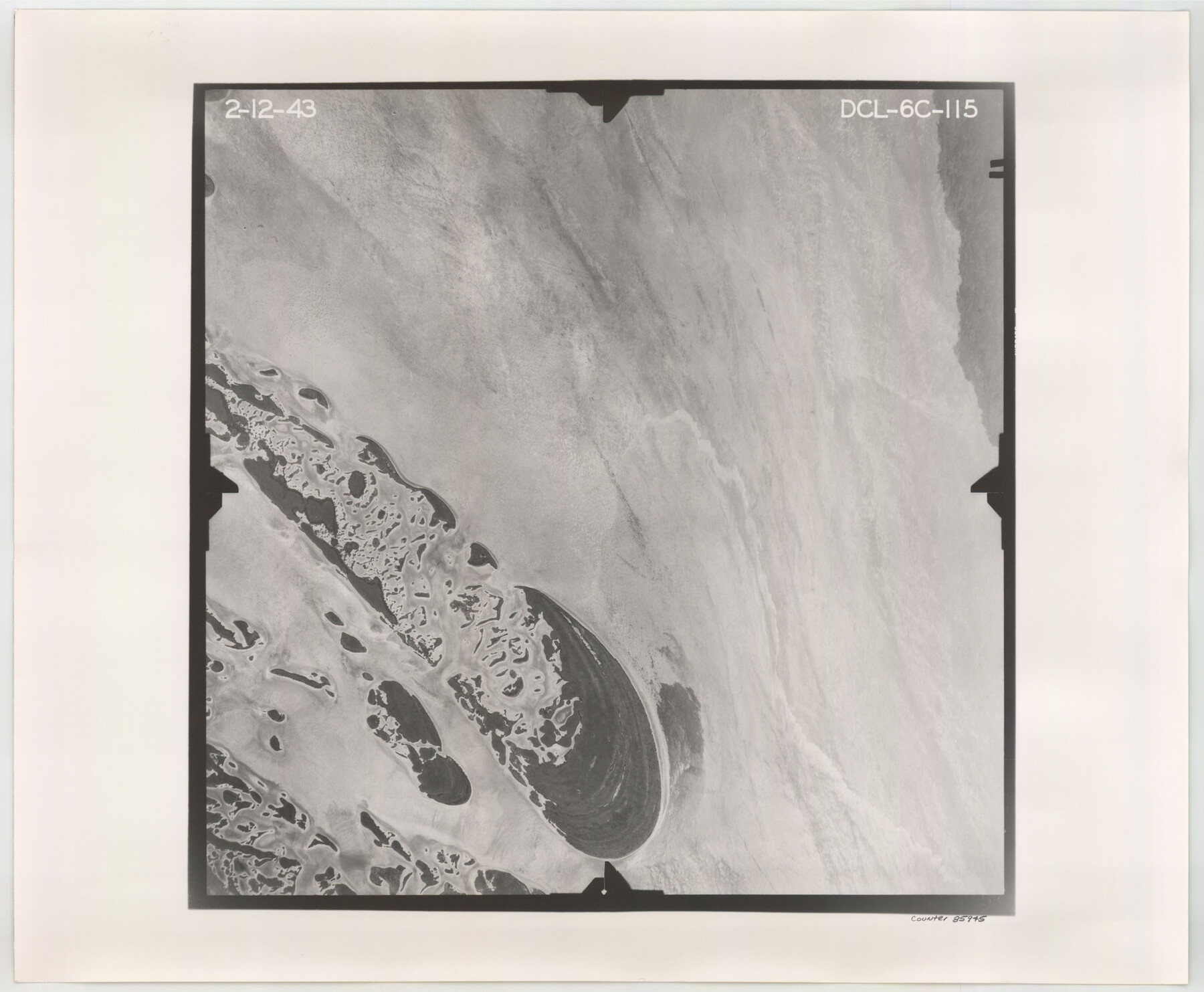
Flight Mission No. DCL-6C, Frame 115, Kenedy County
DCL-6C-115
-
Map/Doc
85945
-
Collection
General Map Collection
-
Object Dates
1943/2/12 (Creation Date)
-
People and Organizations
U. S. Department of Agriculture (Publisher)
-
Counties
Kenedy
-
Subjects
Aerial Photograph
-
Height x Width
18.5 x 22.4 inches
47.0 x 56.9 cm
-
Comments
Flown by Aerial Surveys of Pittsburgh, Inc. of Pittsburgh, Pennsylvania.
Part of: General Map Collection
Montgomery Co.

Print $40.00
- Digital $50.00
Montgomery Co.
1943
Size 45.2 x 54.8 inches
Map/Doc 95594
Copy of Surveyor's Field Book, Morris Browning - In Blocks 7, 5 & 4, I&GNRRCo., Hutchinson and Carson Counties, Texas

Print $2.00
- Digital $50.00
Copy of Surveyor's Field Book, Morris Browning - In Blocks 7, 5 & 4, I&GNRRCo., Hutchinson and Carson Counties, Texas
1888
Size 6.9 x 8.8 inches
Map/Doc 62281
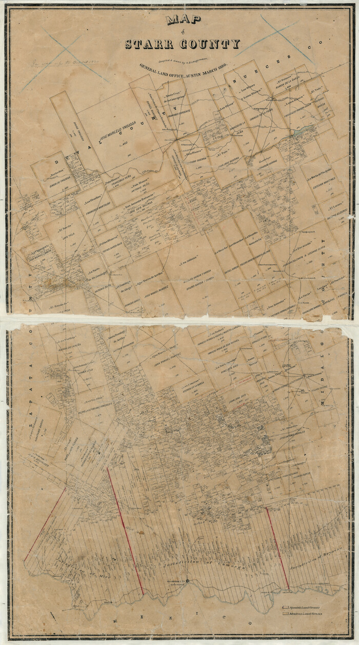
Map of Starr County
Print $20.00
- Digital $50.00
Map of Starr County
1880
Size 46.8 x 27.0 inches
Map/Doc 4044
Carte Reduit d'une partie des Côtes des Isles Australes

Print $20.00
- Digital $50.00
Carte Reduit d'une partie des Côtes des Isles Australes
1782
Size 12.7 x 17.3 inches
Map/Doc 97122
Mitchell County Sketch File 16a

Print $12.00
- Digital $50.00
Mitchell County Sketch File 16a
1933
Size 11.3 x 8.8 inches
Map/Doc 31703
Blanco County Sketch File 31a

Print $4.00
- Digital $50.00
Blanco County Sketch File 31a
1889
Size 8.6 x 14.1 inches
Map/Doc 14631
Right-of-Way & Track Map, Houston & Brazos Valley Ry. operated by Houston & Brazos Valley Ry.

Print $40.00
- Digital $50.00
Right-of-Way & Track Map, Houston & Brazos Valley Ry. operated by Houston & Brazos Valley Ry.
1918
Size 25.0 x 56.3 inches
Map/Doc 64603
[Drawings of individual counties for Pressler and Langermann's 1879 Map of Texas]
![2140, [Drawings of individual counties for Pressler and Langermann's 1879 Map of Texas], General Map Collection](https://historictexasmaps.com/wmedia_w700/maps/2140-1.tif.jpg)
Print $20.00
- Digital $50.00
[Drawings of individual counties for Pressler and Langermann's 1879 Map of Texas]
1878
Size 28.5 x 42.0 inches
Map/Doc 2140
Map of the County of Calhoun

Print $20.00
- Digital $50.00
Map of the County of Calhoun
1852
Size 21.0 x 20.4 inches
Map/Doc 4431
Terrell County Rolled Sketch 58

Print $40.00
- Digital $50.00
Terrell County Rolled Sketch 58
1931
Size 49.1 x 41.8 inches
Map/Doc 9993
Throckmorton County Rolled Sketch 2

Print $20.00
- Digital $50.00
Throckmorton County Rolled Sketch 2
Size 28.9 x 36.3 inches
Map/Doc 7985
Dépt. de la Nièvre

Print $20.00
- Digital $50.00
Dépt. de la Nièvre
Size 14.5 x 20.3 inches
Map/Doc 94452
You may also like
Flight Mission No. DCL-6C, Frame 126, Kenedy County

Print $20.00
- Digital $50.00
Flight Mission No. DCL-6C, Frame 126, Kenedy County
1943
Size 18.5 x 22.3 inches
Map/Doc 85956
Lamb County Sketch File 12

Print $16.00
- Digital $50.00
Lamb County Sketch File 12
Size 8.6 x 7.7 inches
Map/Doc 29363
Starr County Working Sketch 16

Print $20.00
- Digital $50.00
Starr County Working Sketch 16
1981
Size 21.5 x 12.0 inches
Map/Doc 63932
Map of Comanche County

Print $40.00
- Digital $50.00
Map of Comanche County
1895
Size 47.5 x 50.0 inches
Map/Doc 4735
Throckmorton County Working Sketch 5

Print $20.00
- Digital $50.00
Throckmorton County Working Sketch 5
1927
Size 31.8 x 24.4 inches
Map/Doc 62114
Ward County Rolled Sketch 28

Print $20.00
- Digital $50.00
Ward County Rolled Sketch 28
Size 22.3 x 27.5 inches
Map/Doc 8167
Dawson County Rolled Sketch 3

Print $20.00
- Digital $50.00
Dawson County Rolled Sketch 3
1903
Size 20.9 x 36.8 inches
Map/Doc 8770
Sabine River, Greenville Sheet/Cowleach Fork of the Sabine River

Print $20.00
- Digital $50.00
Sabine River, Greenville Sheet/Cowleach Fork of the Sabine River
1935
Size 37.2 x 37.1 inches
Map/Doc 65146
No. 3 Chart of Channel connecting Corpus Christi Bay with Aransas Bay, Texas

Print $20.00
- Digital $50.00
No. 3 Chart of Channel connecting Corpus Christi Bay with Aransas Bay, Texas
1878
Size 18.4 x 28.0 inches
Map/Doc 72775
San Jacinto County Rolled Sketch 6

Print $20.00
- Digital $50.00
San Jacinto County Rolled Sketch 6
Size 42.1 x 43.5 inches
Map/Doc 8361
Montgomery County Sketch File 2a

Print $4.00
- Digital $50.00
Montgomery County Sketch File 2a
1849
Size 8.0 x 12.3 inches
Map/Doc 31768
Val Verde County Sketch File 20

Print $20.00
- Digital $50.00
Val Verde County Sketch File 20
1881
Size 26.5 x 37.2 inches
Map/Doc 12569