Mitchell County Sketch File 16a
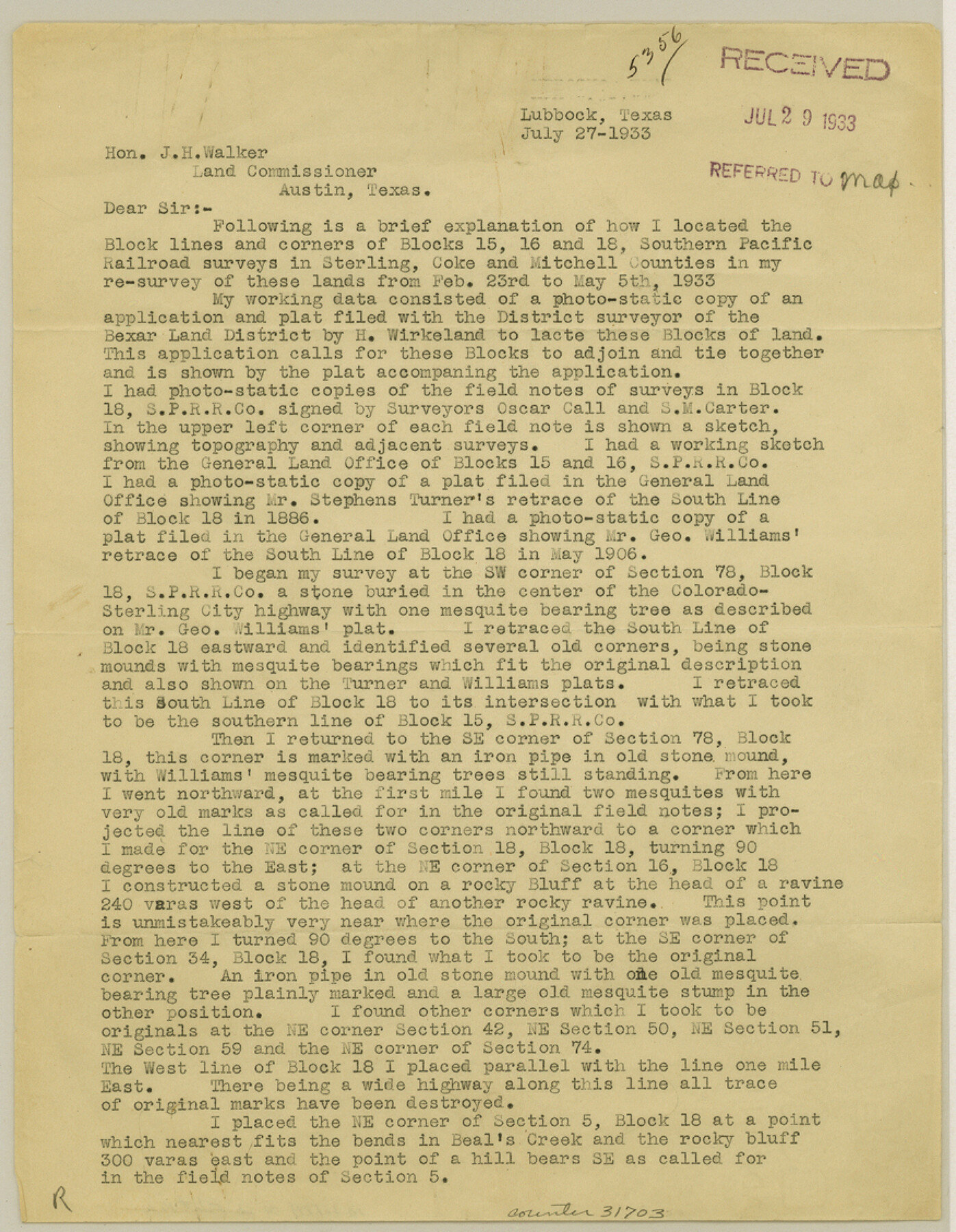
[Explanation on locating of Block lines and corners of Blocks 15, 16 and 18, Southern Pacific Railroad surveys]
-
Map/Doc
31703
-
Collection
General Map Collection
-
Object Dates
7/27/1933 (Creation Date)
2/26/1934 (File Date)
7/27/1933 (Correspondence Date)
2/23/1933 (Survey Date)
5/5/1933 (Survey Date)
2/23/1934 (Correspondence Date)
-
People and Organizations
Sylvan Sanders (Surveyor/Engineer)
H. Wirkeland (Surveyor/Engineer)
Oscar Call (Surveyor/Engineer)
S.M. Carter (Surveyor/Engineer)
George Williams (Surveyor/Engineer)
H.W. Stoneham (Surveyor/Engineer)
-
Counties
Mitchell Sterling Coke
-
Subjects
Surveying Sketch File
-
Height x Width
11.3 x 8.8 inches
28.7 x 22.4 cm
-
Medium
paper, print
-
Comments
See Mitchell County Sketch File 16b (10545) for sketch.
-
Features
Beal's Creek
Wild Horse Creek
Renderbrook Creek
Wilson Mountain
Silver Creek
Colorado River
Related maps
Mitchell County Sketch File 16b

Print $20.00
- Digital $50.00
Mitchell County Sketch File 16b
Size 28.7 x 36.8 inches
Map/Doc 10545
Part of: General Map Collection
Flight Mission No. DIX-10P, Frame 174, Aransas County

Print $20.00
- Digital $50.00
Flight Mission No. DIX-10P, Frame 174, Aransas County
1956
Size 18.5 x 22.2 inches
Map/Doc 83964
Upton County Rolled Sketch 40

Print $20.00
- Digital $50.00
Upton County Rolled Sketch 40
Size 26.2 x 39.7 inches
Map/Doc 8079
Glasscock County Sketch File 23

Print $10.00
- Digital $50.00
Glasscock County Sketch File 23
1948
Size 11.4 x 8.8 inches
Map/Doc 24199
Sutton County Working Sketch 46

Print $40.00
- Digital $50.00
Sutton County Working Sketch 46
1953
Size 48.4 x 27.1 inches
Map/Doc 62389
[Drawings of individual counties for Pressler and Langermann's 1879 Map of Texas]
![2140, [Drawings of individual counties for Pressler and Langermann's 1879 Map of Texas], General Map Collection](https://historictexasmaps.com/wmedia_w700/maps/2140-1.tif.jpg)
Print $20.00
- Digital $50.00
[Drawings of individual counties for Pressler and Langermann's 1879 Map of Texas]
1878
Size 28.5 x 42.0 inches
Map/Doc 2140
Nueces County Rolled Sketch 34

Print $20.00
- Digital $50.00
Nueces County Rolled Sketch 34
1951
Size 47.9 x 37.5 inches
Map/Doc 9601
Falls County Boundary File 1

Print $64.00
- Digital $50.00
Falls County Boundary File 1
Size 9.2 x 4.4 inches
Map/Doc 53241
Leon County Sketch File 22

Print $24.00
- Digital $50.00
Leon County Sketch File 22
Size 12.8 x 8.8 inches
Map/Doc 29772
Sutton County Working Sketch 48

Print $20.00
- Digital $50.00
Sutton County Working Sketch 48
1955
Size 34.8 x 33.1 inches
Map/Doc 62391
Bell County Boundary File 3

Print $24.00
- Digital $50.00
Bell County Boundary File 3
Size 11.1 x 8.6 inches
Map/Doc 50490
Map of Pecos County

Print $40.00
- Digital $50.00
Map of Pecos County
1895
Size 58.1 x 63.4 inches
Map/Doc 16788
El Paso County Rolled Sketch 47

Print $40.00
- Digital $50.00
El Paso County Rolled Sketch 47
1885
Size 41.3 x 90.4 inches
Map/Doc 8874
You may also like
Medina County Rolled Sketch 5

Print $40.00
- Digital $50.00
Medina County Rolled Sketch 5
1948
Size 52.0 x 47.1 inches
Map/Doc 9505
Medina County Working Sketch 17

Print $20.00
- Digital $50.00
Medina County Working Sketch 17
1979
Size 26.8 x 34.5 inches
Map/Doc 70932
Gaines County Working Sketch 10

Print $40.00
- Digital $50.00
Gaines County Working Sketch 10
1953
Size 53.0 x 38.0 inches
Map/Doc 69310
Tarrant County Working Sketch 14

Print $20.00
- Digital $50.00
Tarrant County Working Sketch 14
1989
Size 26.5 x 31.0 inches
Map/Doc 62431
Jeff Davis County Rolled Sketch 22

Print $399.00
- Digital $50.00
Jeff Davis County Rolled Sketch 22
Size 17.2 x 15.8 inches
Map/Doc 6487
![90607, [Block K8], Twichell Survey Records](https://historictexasmaps.com/wmedia_w700/maps/90607-1.tif.jpg)
Chambers County Sketch File 10

Print $4.00
- Digital $50.00
Chambers County Sketch File 10
1869
Size 6.8 x 11.1 inches
Map/Doc 17550
Lavaca County Sketch File 1

Print $4.00
- Digital $50.00
Lavaca County Sketch File 1
1848
Size 12.7 x 8.2 inches
Map/Doc 29628
Flight Mission No. BRA-16M, Frame 92, Jefferson County

Print $20.00
- Digital $50.00
Flight Mission No. BRA-16M, Frame 92, Jefferson County
1953
Size 18.6 x 22.3 inches
Map/Doc 85704
Current Miscellaneous File 114

Print $16.00
- Digital $50.00
Current Miscellaneous File 114
1985
Size 8.9 x 11.3 inches
Map/Doc 74803
Flight Mission No. BRA-16M, Frame 104, Jefferson County

Print $20.00
- Digital $50.00
Flight Mission No. BRA-16M, Frame 104, Jefferson County
1953
Size 18.5 x 22.3 inches
Map/Doc 85716
Aransas County NRC Article 33.136 Sketch 20

Print $22.00
- Digital $50.00
Aransas County NRC Article 33.136 Sketch 20
2022
Map/Doc 96876