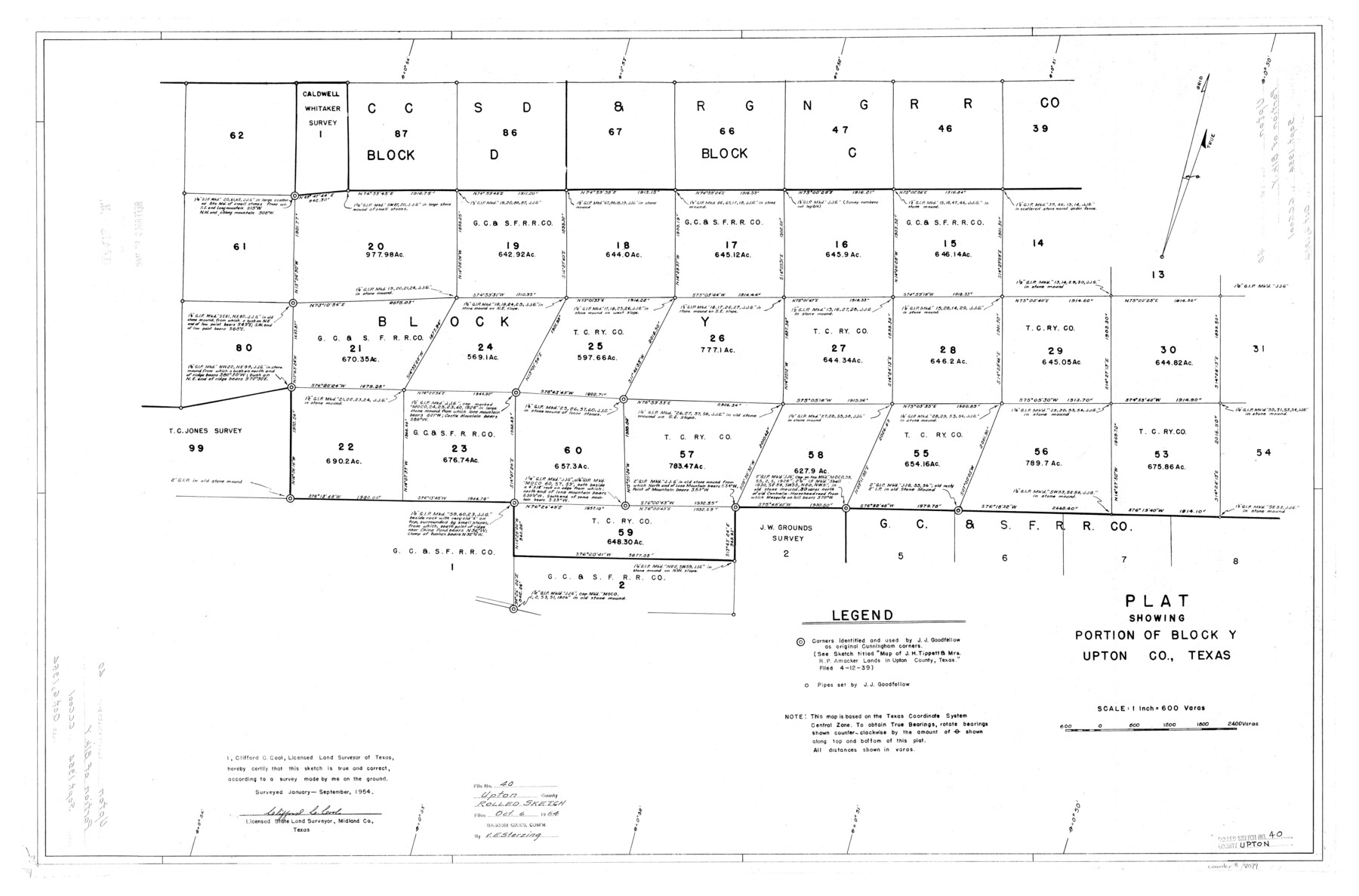
Upton County Rolled Sketch 40
Plat showing portion of Block Y, Upton Co., Texas
-
Map/Doc
8079
-
Collection
General Map Collection
-
Object Dates
1954 (Survey Date)
1954/10/6 (File Date)
-
People and Organizations
Clifford C. Cool (Surveyor/Engineer)
-
Counties
Upton
-
Subjects
Surveying Rolled Sketch
-
Height x Width
26.2 x 39.7 inches
66.5 x 100.8 cm
-
Scale
1" = 600 varas
Part of: General Map Collection
Navarro County Sketch File 16

Print $24.00
- Digital $50.00
Navarro County Sketch File 16
1902
Size 9.7 x 6.3 inches
Map/Doc 32330
Runnels County Sketch File 5a

Print $40.00
Runnels County Sketch File 5a
1883
Size 8.9 x 22.0 inches
Map/Doc 35438
Carson County Working Sketch 1

Print $40.00
- Digital $50.00
Carson County Working Sketch 1
Size 44.6 x 77.4 inches
Map/Doc 67872
Flight Mission No. CRK-7P, Frame 134, Refugio County

Print $20.00
- Digital $50.00
Flight Mission No. CRK-7P, Frame 134, Refugio County
1956
Size 18.4 x 22.1 inches
Map/Doc 86957
Trinity River, Daugherty Lake Sheet/East Fork of Trinity River

Print $20.00
- Digital $50.00
Trinity River, Daugherty Lake Sheet/East Fork of Trinity River
1920
Size 41.9 x 30.1 inches
Map/Doc 65191
Flight Mission No. CRE-2R, Frame 88, Jackson County

Print $20.00
- Digital $50.00
Flight Mission No. CRE-2R, Frame 88, Jackson County
1956
Size 15.9 x 15.9 inches
Map/Doc 85360
Fisher County Sketch File 6a

Print $20.00
- Digital $50.00
Fisher County Sketch File 6a
Size 21.3 x 18.1 inches
Map/Doc 11476
Rand, McNally and Co.'s New Enlarged Scale Railroad and County Map of Texas, Showing Every Railroad Station and Post Office in the State

Print $20.00
- Digital $50.00
Rand, McNally and Co.'s New Enlarged Scale Railroad and County Map of Texas, Showing Every Railroad Station and Post Office in the State
1882
Size 23.7 x 29.8 inches
Map/Doc 2135
No. 3 Chart of Channel connecting Corpus Christi Bay with Aransas Bay, Texas

Print $20.00
- Digital $50.00
No. 3 Chart of Channel connecting Corpus Christi Bay with Aransas Bay, Texas
1878
Size 18.2 x 27.9 inches
Map/Doc 72774
Trinity River, Levee Improvement Districts, Widths of Floodways

Print $20.00
- Digital $50.00
Trinity River, Levee Improvement Districts, Widths of Floodways
1923
Size 37.6 x 28.2 inches
Map/Doc 65253
Flight Mission No. CLL-3N, Frame 43, Willacy County

Print $20.00
- Digital $50.00
Flight Mission No. CLL-3N, Frame 43, Willacy County
1954
Size 18.3 x 22.0 inches
Map/Doc 87101
Houston County Rolled Sketch 10

Print $20.00
- Digital $50.00
Houston County Rolled Sketch 10
1988
Size 31.9 x 25.3 inches
Map/Doc 6230
You may also like
Chicago & Rock Island

Print $40.00
- Digital $50.00
Chicago & Rock Island
1892
Size 8.4 x 70.7 inches
Map/Doc 64498
Montgomery Co.

Print $20.00
- Digital $50.00
Montgomery Co.
1840
Size 34.0 x 30.8 inches
Map/Doc 3191
Parker County Sketch File 4

Print $6.00
- Digital $50.00
Parker County Sketch File 4
1856
Size 6.2 x 5.8 inches
Map/Doc 33525
Hutchinson County

Print $20.00
- Digital $50.00
Hutchinson County
1922
Size 14.6 x 17.6 inches
Map/Doc 91183
General Highway Map, Eastland County, Texas

Print $20.00
General Highway Map, Eastland County, Texas
1940
Size 18.1 x 24.8 inches
Map/Doc 79080
Brazoria County

Print $40.00
- Digital $50.00
Brazoria County
1891
Size 47.1 x 54.2 inches
Map/Doc 4890
Nueces County Rolled Sketch 39

Print $20.00
- Digital $50.00
Nueces County Rolled Sketch 39
1957
Size 32.9 x 45.3 inches
Map/Doc 6879
Scurry County Sketch File 5

Print $4.00
- Digital $50.00
Scurry County Sketch File 5
1990
Size 14.4 x 8.9 inches
Map/Doc 36568
[Surveys in Austin's Colony along the west bank of the San Jacinto River]
![79, [Surveys in Austin's Colony along the west bank of the San Jacinto River], General Map Collection](https://historictexasmaps.com/wmedia_w700/maps/79-1.tif.jpg)
Print $20.00
- Digital $50.00
[Surveys in Austin's Colony along the west bank of the San Jacinto River]
1831
Size 25.0 x 22.0 inches
Map/Doc 79
Reeves County Rolled Sketch 6

Print $20.00
- Digital $50.00
Reeves County Rolled Sketch 6
Size 22.6 x 29.0 inches
Map/Doc 7478
[Red River & Southwestern Ry. Co. from Henrietta to Archer City]
![64147, [Red River & Southwestern Ry. Co. from Henrietta to Archer City], General Map Collection](https://historictexasmaps.com/wmedia_w700/maps/64147.tif.jpg)
Print $20.00
- Digital $50.00
[Red River & Southwestern Ry. Co. from Henrietta to Archer City]
Size 14.3 x 21.1 inches
Map/Doc 64147
