Mitchell County Sketch File 16b

Print $20.00
- Digital $50.00
Mitchell County Sketch File 16b
Size: 28.7 x 36.8 inches
10545
Nolan County Sketch File 1a

Print $20.00
- Digital $50.00
Nolan County Sketch File 1a
1882
Size: 20.7 x 39.4 inches
10554
Nolan County Sketch File 2

Print $40.00
- Digital $50.00
Nolan County Sketch File 2
Size: 49.5 x 41.6 inches
10556
Nolan County Sketch File 4

Print $20.00
- Digital $50.00
Nolan County Sketch File 4
Size: 38.8 x 33.0 inches
10557
Coke County Sketch File 8

Print $20.00
- Digital $50.00
Coke County Sketch File 8
Size: 20.2 x 27.8 inches
11106
Coke County Sketch File 17-18

Print $24.00
- Digital $50.00
Coke County Sketch File 17-18
1902
Size: 16.6 x 14.2 inches
11109
Coke County Sketch File 34

Print $20.00
- Digital $50.00
Coke County Sketch File 34
1888
Size: 17.2 x 21.7 inches
11116
Fisher County Sketch File 10

Print $20.00
- Digital $50.00
Fisher County Sketch File 10
Size: 9.7 x 37.0 inches
11477
Mitchell County Sketch File 5

Print $20.00
- Digital $50.00
Mitchell County Sketch File 5
1906
Size: 17.5 x 22.2 inches
12095
Mitchell County Sketch File 7

Print $20.00
- Digital $50.00
Mitchell County Sketch File 7
1906
Size: 19.4 x 12.4 inches
12096
Mitchell County Sketch File 7A

Print $20.00
- Digital $50.00
Mitchell County Sketch File 7A
1906
Size: 20.4 x 14.0 inches
12097
Mitchell County Sketch File 8

Print $20.00
- Digital $50.00
Mitchell County Sketch File 8
1909
Size: 26.9 x 20.9 inches
12098
Mitchell County Sketch File 12

Print $20.00
- Digital $50.00
Mitchell County Sketch File 12
1912
Size: 25.6 x 14.0 inches
12099
Mitchell County Sketch File 13

Print $20.00
- Digital $50.00
Mitchell County Sketch File 13
1925
Size: 19.3 x 16.3 inches
12100
Mitchell County Sketch File 14

Print $20.00
- Digital $50.00
Mitchell County Sketch File 14
1930
Size: 17.5 x 20.5 inches
12101
Mitchell County Sketch File 15

Print $20.00
- Digital $50.00
Mitchell County Sketch File 15
1931
Size: 19.2 x 19.6 inches
12102
Mitchell County Sketch File 18

Print $20.00
- Digital $50.00
Mitchell County Sketch File 18
Size: 32.1 x 13.6 inches
12103
Mitchell County Sketch File X

Print $20.00
- Digital $50.00
Mitchell County Sketch File X
1908
Size: 29.9 x 17.7 inches
12104
Scurry County Sketch File 3

Print $20.00
- Digital $50.00
Scurry County Sketch File 3
Size: 22.0 x 24.2 inches
12312
Sterling County Sketch File 14

Print $20.00
- Digital $50.00
Sterling County Sketch File 14
Size: 18.9 x 16.4 inches
12360
Borden County Sketch File 3

Print $4.00
- Digital $50.00
Borden County Sketch File 3
1902
Size: 7.3 x 12.8 inches
14703
[Tom Green County]
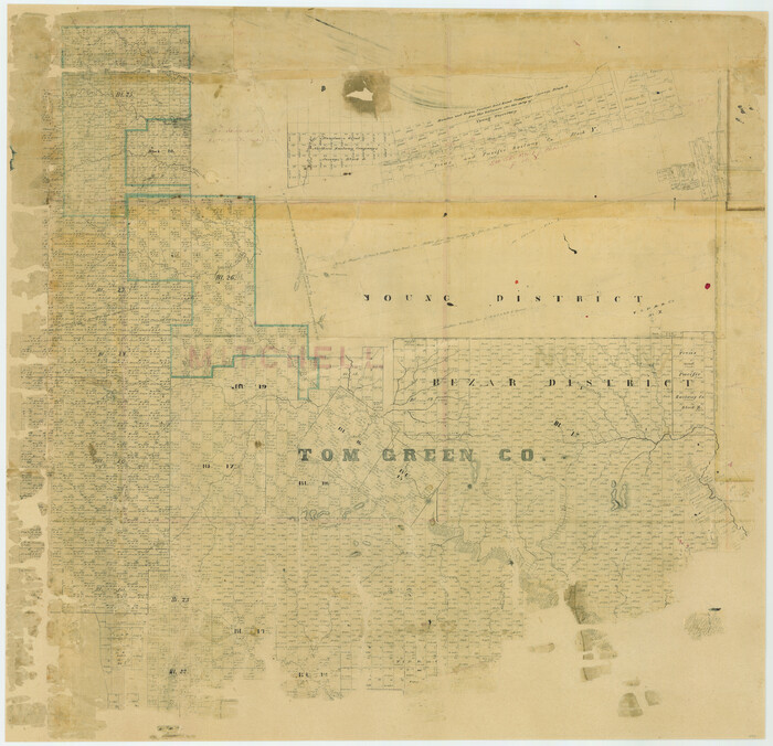
Print $20.00
- Digital $50.00
[Tom Green County]
1888
Size: 33.2 x 34.4 inches
16901
[Plat No. 1, Connecting line from SW corner of Jones Co. to SE corner of Borden Co.]
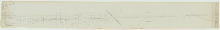
Print $40.00
- Digital $50.00
[Plat No. 1, Connecting line from SW corner of Jones Co. to SE corner of Borden Co.]
1908
Size: 18.1 x 128.8 inches
1698
Coke County Sketch File 4

Print $46.00
- Digital $50.00
Coke County Sketch File 4
1884
Size: 9.2 x 7.7 inches
18566
Map of Southeastern Part of Young Territory

Print $40.00
- Digital $50.00
Map of Southeastern Part of Young Territory
1874
Size: 54.7 x 30.1 inches
1989
Map of Surveys Made for the T&PRRCo in Howard, Mitchell & Tom Green Counties, Blocks 27, 28, 29, 30, 31, 32 & 33, Reserve West of the Colorado

Print $40.00
- Digital $50.00
Map of Surveys Made for the T&PRRCo in Howard, Mitchell & Tom Green Counties, Blocks 27, 28, 29, 30, 31, 32 & 33, Reserve West of the Colorado
1876
Size: 42.0 x 51.0 inches
2228
Map of Surveys Made for the T&PRR in Borden, Howard & Mitchell Counties, Blocks 27, 28, 29, 30 & 31, Reserve West of the Colorado

Print $20.00
- Digital $50.00
Map of Surveys Made for the T&PRR in Borden, Howard & Mitchell Counties, Blocks 27, 28, 29, 30 & 31, Reserve West of the Colorado
1876
Size: 42.8 x 39.7 inches
2230
Map of the Texas & Pacific Railway Company Reserve west of the Colorado River

Print $40.00
- Digital $50.00
Map of the Texas & Pacific Railway Company Reserve west of the Colorado River
1877
Size: 48.9 x 59.2 inches
2233
Mitchell County Sketch File 16b
Print $20.00
- Digital $50.00
Mitchell County Sketch File 16b
-
Size
28.7 x 36.8 inches
-
Map/Doc
10545
Nolan County Sketch File 1a
Print $20.00
- Digital $50.00
Nolan County Sketch File 1a
1882
-
Size
20.7 x 39.4 inches
-
Map/Doc
10554
-
Creation Date
1882
Nolan County Sketch File 2
Print $40.00
- Digital $50.00
Nolan County Sketch File 2
-
Size
49.5 x 41.6 inches
-
Map/Doc
10556
Nolan County Sketch File 4
Print $20.00
- Digital $50.00
Nolan County Sketch File 4
-
Size
38.8 x 33.0 inches
-
Map/Doc
10557
Mitchell County

Print $20.00
- Digital $50.00
Mitchell County
1889
-
Size
42.3 x 35.7 inches
-
Map/Doc
10792
-
Creation Date
1889
Coke County Sketch File 8
Print $20.00
- Digital $50.00
Coke County Sketch File 8
-
Size
20.2 x 27.8 inches
-
Map/Doc
11106
Coke County Sketch File 17-18
Print $24.00
- Digital $50.00
Coke County Sketch File 17-18
1902
-
Size
16.6 x 14.2 inches
-
Map/Doc
11109
-
Creation Date
1902
Coke County Sketch File 34
Print $20.00
- Digital $50.00
Coke County Sketch File 34
1888
-
Size
17.2 x 21.7 inches
-
Map/Doc
11116
-
Creation Date
1888
Fisher County Sketch File 10
Print $20.00
- Digital $50.00
Fisher County Sketch File 10
-
Size
9.7 x 37.0 inches
-
Map/Doc
11477
Mitchell County Sketch File 5
Print $20.00
- Digital $50.00
Mitchell County Sketch File 5
1906
-
Size
17.5 x 22.2 inches
-
Map/Doc
12095
-
Creation Date
1906
Mitchell County Sketch File 7
Print $20.00
- Digital $50.00
Mitchell County Sketch File 7
1906
-
Size
19.4 x 12.4 inches
-
Map/Doc
12096
-
Creation Date
1906
Mitchell County Sketch File 7A
Print $20.00
- Digital $50.00
Mitchell County Sketch File 7A
1906
-
Size
20.4 x 14.0 inches
-
Map/Doc
12097
-
Creation Date
1906
Mitchell County Sketch File 8
Print $20.00
- Digital $50.00
Mitchell County Sketch File 8
1909
-
Size
26.9 x 20.9 inches
-
Map/Doc
12098
-
Creation Date
1909
Mitchell County Sketch File 12
Print $20.00
- Digital $50.00
Mitchell County Sketch File 12
1912
-
Size
25.6 x 14.0 inches
-
Map/Doc
12099
-
Creation Date
1912
Mitchell County Sketch File 13
Print $20.00
- Digital $50.00
Mitchell County Sketch File 13
1925
-
Size
19.3 x 16.3 inches
-
Map/Doc
12100
-
Creation Date
1925
Mitchell County Sketch File 14
Print $20.00
- Digital $50.00
Mitchell County Sketch File 14
1930
-
Size
17.5 x 20.5 inches
-
Map/Doc
12101
-
Creation Date
1930
Mitchell County Sketch File 15
Print $20.00
- Digital $50.00
Mitchell County Sketch File 15
1931
-
Size
19.2 x 19.6 inches
-
Map/Doc
12102
-
Creation Date
1931
Mitchell County Sketch File 18
Print $20.00
- Digital $50.00
Mitchell County Sketch File 18
-
Size
32.1 x 13.6 inches
-
Map/Doc
12103
Mitchell County Sketch File X
Print $20.00
- Digital $50.00
Mitchell County Sketch File X
1908
-
Size
29.9 x 17.7 inches
-
Map/Doc
12104
-
Creation Date
1908
Scurry County Sketch File 3
Print $20.00
- Digital $50.00
Scurry County Sketch File 3
-
Size
22.0 x 24.2 inches
-
Map/Doc
12312
Sterling County Sketch File 14
Print $20.00
- Digital $50.00
Sterling County Sketch File 14
-
Size
18.9 x 16.4 inches
-
Map/Doc
12360
Borden County Sketch File 3
Print $4.00
- Digital $50.00
Borden County Sketch File 3
1902
-
Size
7.3 x 12.8 inches
-
Map/Doc
14703
-
Creation Date
1902
[Tom Green County]
Print $20.00
- Digital $50.00
[Tom Green County]
1888
-
Size
33.2 x 34.4 inches
-
Map/Doc
16901
-
Creation Date
1888
[Plat No. 1, Connecting line from SW corner of Jones Co. to SE corner of Borden Co.]
Print $40.00
- Digital $50.00
[Plat No. 1, Connecting line from SW corner of Jones Co. to SE corner of Borden Co.]
1908
-
Size
18.1 x 128.8 inches
-
Map/Doc
1698
-
Creation Date
1908
Coke County Sketch File 4
Print $46.00
- Digital $50.00
Coke County Sketch File 4
1884
-
Size
9.2 x 7.7 inches
-
Map/Doc
18566
-
Creation Date
1884
Young Territory

Print $20.00
- Digital $50.00
Young Territory
1873
-
Size
29.2 x 29.9 inches
-
Map/Doc
1976
-
Creation Date
1873
Map of Southeastern Part of Young Territory
Print $40.00
- Digital $50.00
Map of Southeastern Part of Young Territory
1874
-
Size
54.7 x 30.1 inches
-
Map/Doc
1989
-
Creation Date
1874
Map of Surveys Made for the T&PRRCo in Howard, Mitchell & Tom Green Counties, Blocks 27, 28, 29, 30, 31, 32 & 33, Reserve West of the Colorado
Print $40.00
- Digital $50.00
Map of Surveys Made for the T&PRRCo in Howard, Mitchell & Tom Green Counties, Blocks 27, 28, 29, 30, 31, 32 & 33, Reserve West of the Colorado
1876
-
Size
42.0 x 51.0 inches
-
Map/Doc
2228
-
Creation Date
1876
Map of Surveys Made for the T&PRR in Borden, Howard & Mitchell Counties, Blocks 27, 28, 29, 30 & 31, Reserve West of the Colorado
Print $20.00
- Digital $50.00
Map of Surveys Made for the T&PRR in Borden, Howard & Mitchell Counties, Blocks 27, 28, 29, 30 & 31, Reserve West of the Colorado
1876
-
Size
42.8 x 39.7 inches
-
Map/Doc
2230
-
Creation Date
1876
Map of the Texas & Pacific Railway Company Reserve west of the Colorado River
Print $40.00
- Digital $50.00
Map of the Texas & Pacific Railway Company Reserve west of the Colorado River
1877
-
Size
48.9 x 59.2 inches
-
Map/Doc
2233
-
Creation Date
1877