Nolan County Sketch File 2
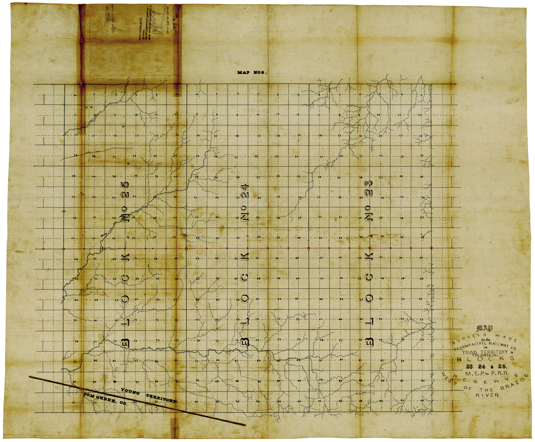
Map of surveys made for the Texas & Pacific Railway Co. in Young Territory & Tom Green Co. Blocks 23, 24 & 25, M. El. P. & P. R.R. Reserve west of the Brazos River
-
Map/Doc
10556
-
Collection
General Map Collection
-
Object Dates
9/2/1875 (File Date)
-
Counties
Nolan Mitchell Fisher Scurry
-
Subjects
Surveying Sketch File
-
Height x Width
49.5 x 41.6 inches
125.7 x 105.7 cm
-
Medium
paper, manuscript
-
Features
Lone Wolf Creek
Cetti's Trail
North Fork of Champlin's Creek
Champlin's Creek
Brazos River
Part of: General Map Collection
Kinney County Sketch File 36

Print $20.00
- Digital $50.00
Kinney County Sketch File 36
1946
Size 19.2 x 22.0 inches
Map/Doc 11949
Map of subdivision of submerged land in the Gulf of Mexico fronting on Matagorda Island and Peninsula

Print $40.00
- Digital $50.00
Map of subdivision of submerged land in the Gulf of Mexico fronting on Matagorda Island and Peninsula
1940
Size 28.2 x 61.3 inches
Map/Doc 2929
Newton County Sketch File 6

Print $4.00
- Digital $50.00
Newton County Sketch File 6
1872
Size 12.4 x 7.9 inches
Map/Doc 32372
Brown County Working Sketch 14

Print $20.00
- Digital $50.00
Brown County Working Sketch 14
1989
Size 20.1 x 21.3 inches
Map/Doc 67779
Hopkins County Sketch File 10a

Print $4.00
- Digital $50.00
Hopkins County Sketch File 10a
1856
Size 12.2 x 7.8 inches
Map/Doc 26702
Roberts County Working Sketch 4

Print $20.00
- Digital $50.00
Roberts County Working Sketch 4
1945
Size 37.1 x 32.8 inches
Map/Doc 63530
Corpus Christi Bay

Print $20.00
- Digital $50.00
Corpus Christi Bay
1961
Size 36.0 x 47.4 inches
Map/Doc 73471
Brazos County Rolled Sketch 6

Print $20.00
- Digital $50.00
Brazos County Rolled Sketch 6
1979
Size 24.3 x 36.4 inches
Map/Doc 5190
[Surveys in Bastrop County]
![3179, [Surveys in Bastrop County], General Map Collection](https://historictexasmaps.com/wmedia_w700/maps/3179.tif.jpg)
Print $2.00
- Digital $50.00
[Surveys in Bastrop County]
1841
Size 11.3 x 8.4 inches
Map/Doc 3179
Hutchinson County Working Sketch 46

Print $20.00
- Digital $50.00
Hutchinson County Working Sketch 46
1979
Size 20.4 x 22.3 inches
Map/Doc 66406
Glasscock County Sketch File 10

Print $6.00
- Digital $50.00
Glasscock County Sketch File 10
1935
Size 11.6 x 12.8 inches
Map/Doc 24172
McCulloch County Sketch File 9

Print $6.00
- Digital $50.00
McCulloch County Sketch File 9
1883
Size 7.3 x 8.7 inches
Map/Doc 31184
You may also like
Bee County Sketch File 34

Print $14.00
Bee County Sketch File 34
2022
Size 11.0 x 8.5 inches
Map/Doc 97030
Flight Mission No. DQN-1K, Frame 136, Calhoun County

Print $20.00
- Digital $50.00
Flight Mission No. DQN-1K, Frame 136, Calhoun County
1953
Size 18.5 x 22.3 inches
Map/Doc 84199
Coryell County, Texas

Print $20.00
- Digital $50.00
Coryell County, Texas
1879
Size 23.5 x 29.1 inches
Map/Doc 704
Caldwell County

Print $20.00
- Digital $50.00
Caldwell County
1935
Size 36.1 x 40.3 inches
Map/Doc 77227
Swisher County Sketch File 1

Print $28.00
- Digital $50.00
Swisher County Sketch File 1
1884
Size 13.0 x 8.2 inches
Map/Doc 37566
[Sketch of part of G. & M. Block 5]
![93073, [Sketch of part of G. & M. Block 5], Twichell Survey Records](https://historictexasmaps.com/wmedia_w700/maps/93073-1.tif.jpg)
Print $2.00
- Digital $50.00
[Sketch of part of G. & M. Block 5]
Size 6.7 x 8.7 inches
Map/Doc 93073
San Saba County Sketch File 14

Print $20.00
- Digital $50.00
San Saba County Sketch File 14
1891
Size 25.5 x 33.3 inches
Map/Doc 12293
Sabine County Working Sketch 6

Print $20.00
- Digital $50.00
Sabine County Working Sketch 6
1918
Size 17.5 x 17.6 inches
Map/Doc 63677
Angelina County Working Sketch 6

Print $20.00
- Digital $50.00
Angelina County Working Sketch 6
1914
Size 17.5 x 15.1 inches
Map/Doc 67087
Hood County Boundary File 40

Print $44.00
- Digital $50.00
Hood County Boundary File 40
Size 14.4 x 8.8 inches
Map/Doc 55019
DeWitt County Working Sketch 16

Print $20.00
- Digital $50.00
DeWitt County Working Sketch 16
1920
Size 23.0 x 25.1 inches
Map/Doc 69016
Reagan County Sketch File 31

Print $20.00
- Digital $50.00
Reagan County Sketch File 31
1951
Size 24.9 x 20.5 inches
Map/Doc 12227