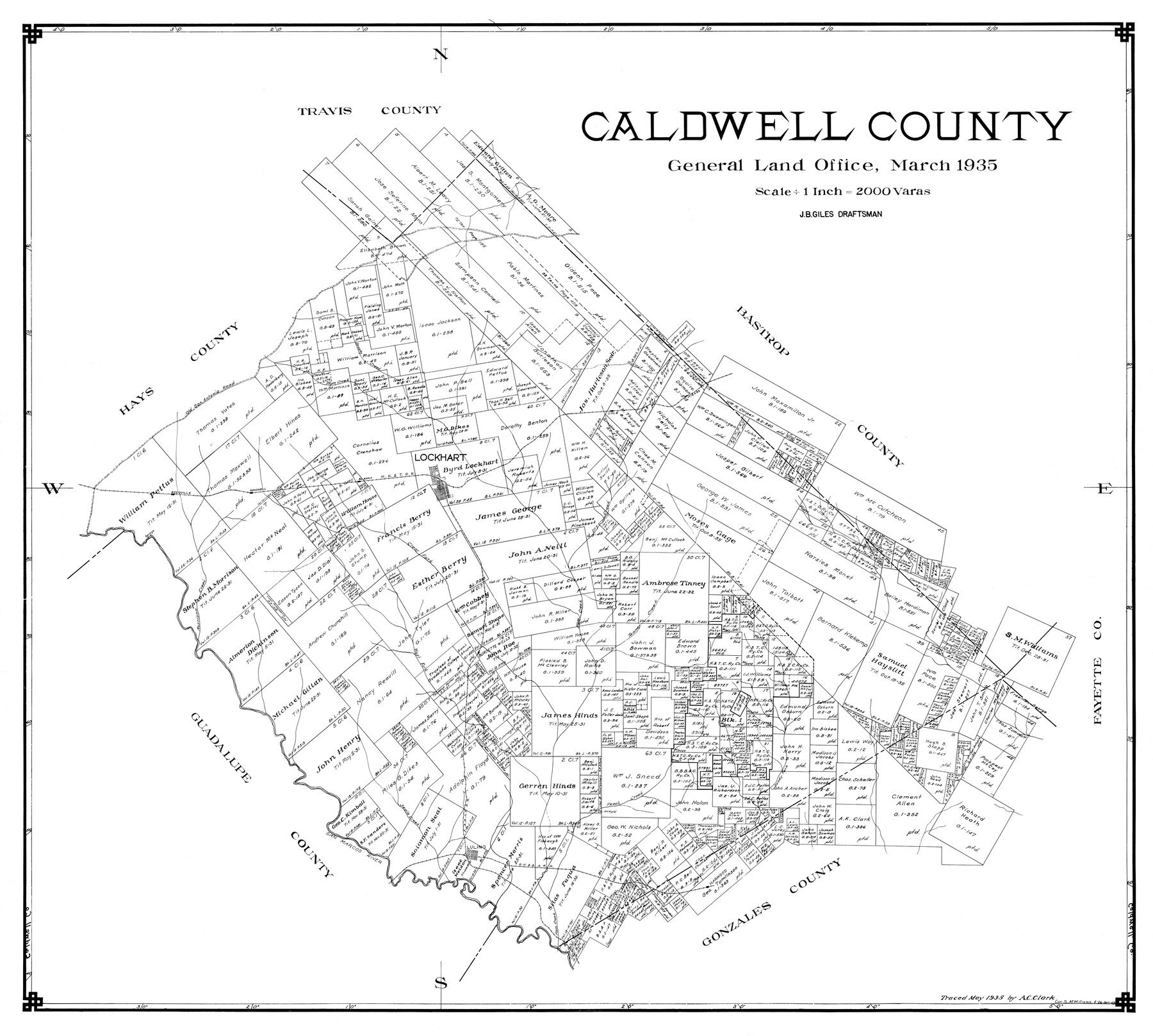
Caldwell County
-
Map/Doc
77227
-
Collection
General Map Collection
-
Object Dates
3/1935 (Creation Date)
-
People and Organizations
J. Bascom Giles (Draftsman)
-
Counties
Caldwell
-
Subjects
County
-
Height x Width
36.1 x 40.3 inches
91.7 x 102.4 cm
-
Scale
1" = 2000 varas
Part of: General Map Collection
Starr County Sketch File 51

Print $22.00
- Digital $50.00
Starr County Sketch File 51
1967
Size 12.2 x 15.6 inches
Map/Doc 37009
Motley County Sketch File 2 (N)

Print $22.00
- Digital $50.00
Motley County Sketch File 2 (N)
Size 8.3 x 14.8 inches
Map/Doc 31996
Hall County Sketch File 4

Print $6.00
- Digital $50.00
Hall County Sketch File 4
Size 14.2 x 9.3 inches
Map/Doc 24800
Hays County Rolled Sketch 32

Print $20.00
- Digital $50.00
Hays County Rolled Sketch 32
2003
Size 15.6 x 20.0 inches
Map/Doc 78489
Liberty County Sketch File 65

Print $4.00
- Digital $50.00
Liberty County Sketch File 65
1895
Size 11.0 x 8.7 inches
Map/Doc 30128

[Surveys in Power and Hewetson's Colony]
![2, [Surveys in Power and Hewetson's Colony], General Map Collection](https://historictexasmaps.com/wmedia_w700/maps/2.tif.jpg)
Print $20.00
- Digital $50.00
[Surveys in Power and Hewetson's Colony]
1830
Size 21.3 x 22.5 inches
Map/Doc 2
Ward County Working Sketch 31

Print $40.00
- Digital $50.00
Ward County Working Sketch 31
1967
Size 32.0 x 75.6 inches
Map/Doc 72337
Ochiltree County Boundary File 8

Print $8.00
- Digital $50.00
Ochiltree County Boundary File 8
Size 11.2 x 8.7 inches
Map/Doc 57716
Flight Mission No. CUG-3P, Frame 172, Kleberg County

Print $20.00
- Digital $50.00
Flight Mission No. CUG-3P, Frame 172, Kleberg County
1956
Size 18.6 x 22.2 inches
Map/Doc 86292
Real County Working Sketch 25

Print $20.00
- Digital $50.00
Real County Working Sketch 25
1946
Size 26.5 x 24.7 inches
Map/Doc 71917
Cass County Working Sketch 5

Print $20.00
- Digital $50.00
Cass County Working Sketch 5
1936
Size 45.6 x 43.1 inches
Map/Doc 67908
You may also like
Flight Mission No. BRA-8M, Frame 128, Jefferson County

Print $20.00
- Digital $50.00
Flight Mission No. BRA-8M, Frame 128, Jefferson County
1953
Size 18.6 x 22.3 inches
Map/Doc 85624
Milam County Boundary File 1

Print $8.00
- Digital $50.00
Milam County Boundary File 1
Size 12.7 x 8.2 inches
Map/Doc 57198
Jack County Sketch File 18

Print $4.00
- Digital $50.00
Jack County Sketch File 18
1880
Size 10.4 x 8.2 inches
Map/Doc 27553
Bosque County, Texas School Map

Print $20.00
- Digital $50.00
Bosque County, Texas School Map
1932
Size 40.9 x 36.6 inches
Map/Doc 81918
Current Miscellaneous File 97

Print $16.00
- Digital $50.00
Current Miscellaneous File 97
1847
Size 11.3 x 8.8 inches
Map/Doc 74329
Flight Mission No. DQN-2K, Frame 189, Calhoun County

Print $20.00
- Digital $50.00
Flight Mission No. DQN-2K, Frame 189, Calhoun County
1953
Size 16.1 x 16.0 inches
Map/Doc 84330
Galveston Bay Entrance - Galveston and Texas City Harbors

Print $40.00
- Digital $50.00
Galveston Bay Entrance - Galveston and Texas City Harbors
Size 38.3 x 54.8 inches
Map/Doc 78271

Harris County NRC Article 33.136 Sketch 5

Print $20.00
- Digital $50.00
Harris County NRC Article 33.136 Sketch 5
2002
Size 22.2 x 34.1 inches
Map/Doc 77047
Current Miscellaneous File 39

Print $20.00
- Digital $50.00
Current Miscellaneous File 39
Size 11.2 x 8.8 inches
Map/Doc 73962
Jackson County Sketch File 22

Print $10.00
- Digital $50.00
Jackson County Sketch File 22
Size 11.2 x 8.7 inches
Map/Doc 27698
Jeff Davis County Working Sketch 49

Print $20.00
- Digital $50.00
Jeff Davis County Working Sketch 49
2008
Size 38.0 x 35.7 inches
Map/Doc 88816