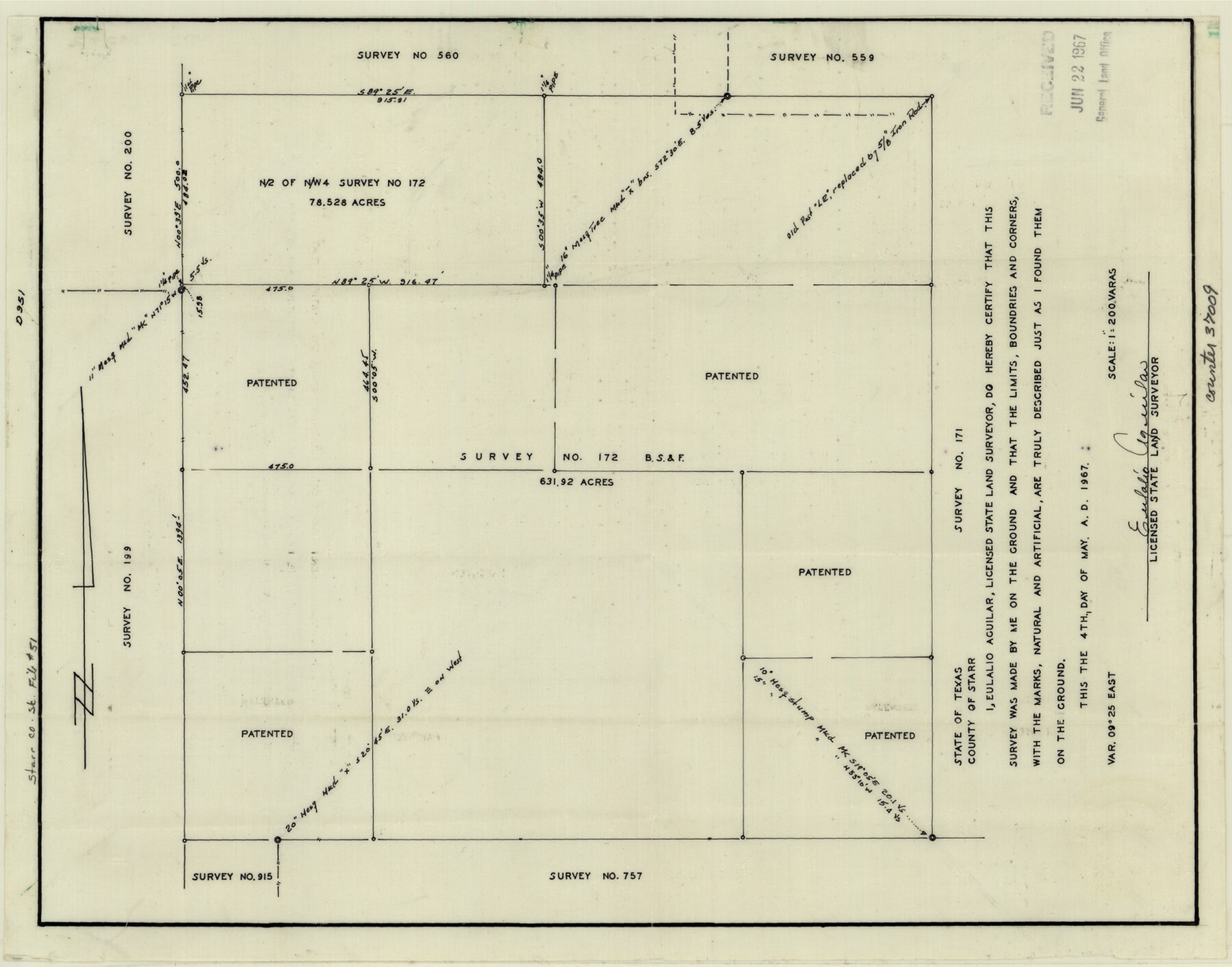
Starr County Sketch File 51
[Report and sketch of the n/2 of the nw/4 of survey 172, B. S. & F.]
-
Map/Doc
37009
-
Collection
General Map Collection
-
Object Dates
5/1967 (Creation Date)
6/22/1967 (File Date)
-
People and Organizations
Eulalio Aguilar (Surveyor/Engineer)
-
Counties
Starr
-
Subjects
Surveying Sketch File
-
Height x Width
12.2 x 15.6 inches
31.0 x 39.6 cm
-
Medium
multi-page, multi-format
-
Scale
1" = 200 varas
Part of: General Map Collection
Flight Mission No. CGI-3N, Frame 110, Cameron County

Print $20.00
- Digital $50.00
Flight Mission No. CGI-3N, Frame 110, Cameron County
1954
Size 18.5 x 22.1 inches
Map/Doc 84590
Goliad County

Print $20.00
- Digital $50.00
Goliad County
1946
Size 42.8 x 45.0 inches
Map/Doc 73159
Jackson County Sketch File 12

Print $20.00
- Digital $50.00
Jackson County Sketch File 12
1907
Size 12.3 x 20.7 inches
Map/Doc 11838
Schleicher County Rolled Sketch 27

Print $20.00
- Digital $50.00
Schleicher County Rolled Sketch 27
Size 37.4 x 43.3 inches
Map/Doc 9909
Real County Working Sketch 5

Print $20.00
- Digital $50.00
Real County Working Sketch 5
1924
Size 17.9 x 29.1 inches
Map/Doc 71897
Flight Mission No. CON-2R, Frame 116, Stonewall County

Print $20.00
- Digital $50.00
Flight Mission No. CON-2R, Frame 116, Stonewall County
1957
Size 18.3 x 22.2 inches
Map/Doc 86990
Current Miscellaneous File 9

Print $66.00
- Digital $50.00
Current Miscellaneous File 9
Size 6.5 x 8.2 inches
Map/Doc 73741

[Sketch of Col. Cooke's Military Road expedition from Red River to Austin]
![82272, [Sketch of Col. Cooke's Military Road expedition from Red River to Austin], General Map Collection](https://historictexasmaps.com/wmedia_w700/maps/82272-1.tif.jpg)
Print $40.00
- Digital $50.00
[Sketch of Col. Cooke's Military Road expedition from Red River to Austin]
Size 61.0 x 24.1 inches
Map/Doc 82272
Llano County Sketch File 13

Print $4.00
- Digital $50.00
Llano County Sketch File 13
1891
Size 9.2 x 15.3 inches
Map/Doc 30387
Morris County Rolled Sketch 2A

Print $20.00
- Digital $50.00
Morris County Rolled Sketch 2A
Size 24.0 x 18.6 inches
Map/Doc 10235
Grayson County Working Sketch 23

Print $20.00
- Digital $50.00
Grayson County Working Sketch 23
1976
Size 18.6 x 24.3 inches
Map/Doc 63262
You may also like
McCulloch County Sketch File 5A

Print $20.00
- Digital $50.00
McCulloch County Sketch File 5A
Size 14.8 x 17.4 inches
Map/Doc 12056
[Sketch for Mineral Application 16341 - Clear Fork of Brazos River, Taylor & Holcomb]
![65571, [Sketch for Mineral Application 16341 - Clear Fork of Brazos River, Taylor & Holcomb], General Map Collection](https://historictexasmaps.com/wmedia_w700/maps/65571.tif.jpg)
Print $40.00
- Digital $50.00
[Sketch for Mineral Application 16341 - Clear Fork of Brazos River, Taylor & Holcomb]
1926
Size 122.3 x 36.7 inches
Map/Doc 65571
Crockett County Sketch File 79

Print $18.00
- Digital $50.00
Crockett County Sketch File 79
1937
Size 11.1 x 8.8 inches
Map/Doc 19881
Whiteface Cemetery

Print $20.00
- Digital $50.00
Whiteface Cemetery
Size 29.3 x 18.0 inches
Map/Doc 92525
Kleberg County Rolled Sketch 10-18

Print $20.00
- Digital $50.00
Kleberg County Rolled Sketch 10-18
1952
Size 37.3 x 38.2 inches
Map/Doc 9364
Texas-United States Boundary Line 5

Print $68.00
- Digital $50.00
Texas-United States Boundary Line 5
1997
Size 9.6 x 6.4 inches
Map/Doc 74994
DeWitt County Sketch File 14

Print $8.00
- Digital $50.00
DeWitt County Sketch File 14
1873
Size 12.8 x 8.2 inches
Map/Doc 20827
Flight Mission No. BRA-8M, Frame 87, Jefferson County

Print $20.00
- Digital $50.00
Flight Mission No. BRA-8M, Frame 87, Jefferson County
1953
Size 18.6 x 22.3 inches
Map/Doc 85607
Dimmit County Sketch File 55

Print $20.00
- Digital $50.00
Dimmit County Sketch File 55
1926
Size 23.1 x 15.7 inches
Map/Doc 11359

Brooks County Sketch File 9

Print $2.00
- Digital $50.00
Brooks County Sketch File 9
1988
Size 14.4 x 8.8 inches
Map/Doc 16571
[Galveston, Harrisburg & San Antonio Railroad from Cuero to Stockdale]
![64192, [Galveston, Harrisburg & San Antonio Railroad from Cuero to Stockdale], General Map Collection](https://historictexasmaps.com/wmedia_w700/maps/64192.tif.jpg)
Print $20.00
- Digital $50.00
[Galveston, Harrisburg & San Antonio Railroad from Cuero to Stockdale]
1907
Size 14.1 x 34.1 inches
Map/Doc 64192