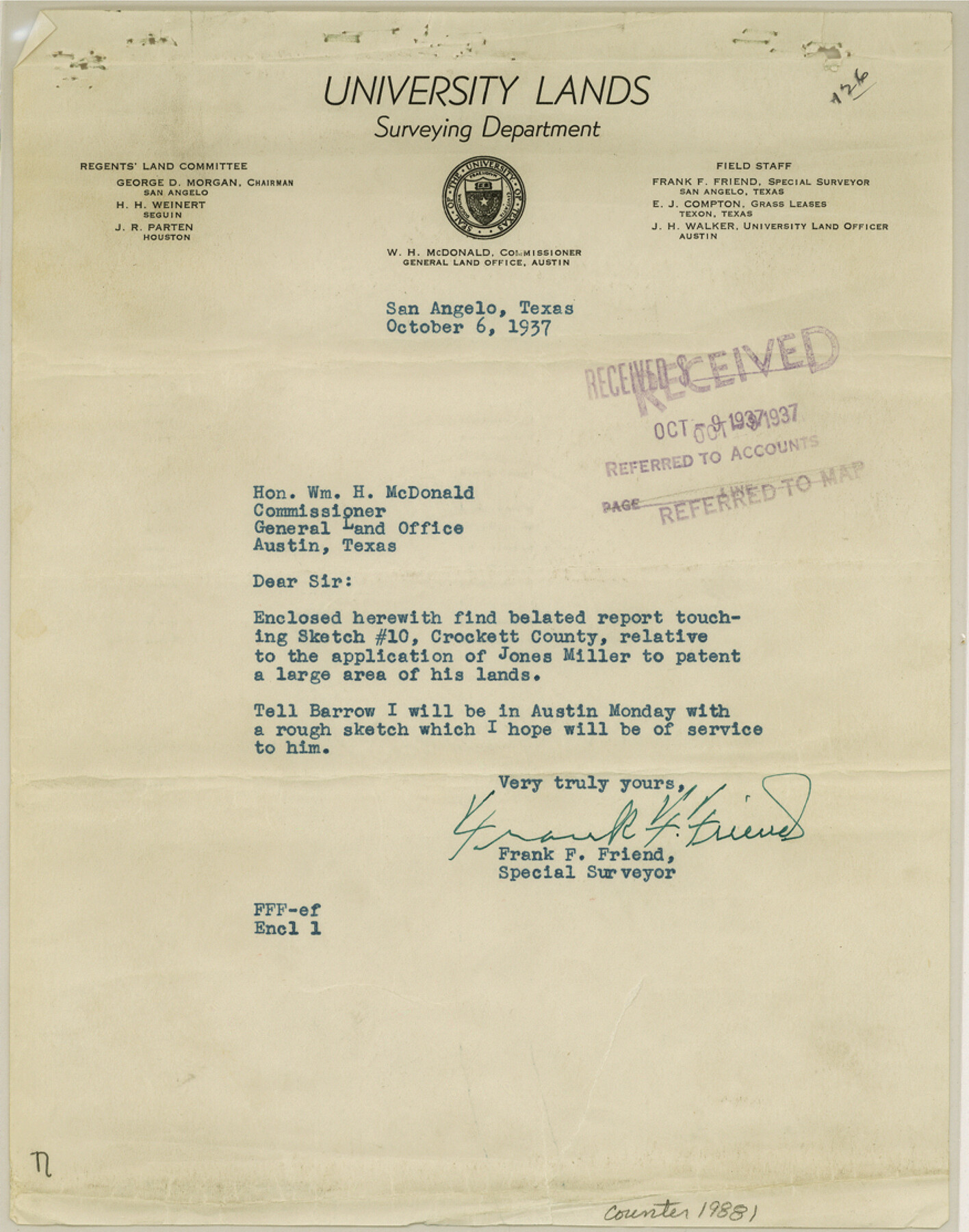
Crockett County Sketch File 79
[Surveyor's report of Sketch #10 being a map of a part of Crockett County, Texas]
-
Map/Doc
19881
-
Collection
General Map Collection
-
Object Dates
1937/9/30 (Creation Date)
1937/10/9 (File Date)
1876 (Survey Date)
1880 (Survey Date)
1886 (Survey Date)
1889 (Survey Date)
-
People and Organizations
Frank F. Friend (Surveyor/Engineer)
Jacob Kuechler (Surveyor/Engineer)
William Cassin (Surveyor/Engineer)
Will H. Bonnell (Surveyor/Engineer)
G.M. Williams (Surveyor/Engineer)
-
Counties
Crockett
-
Subjects
Surveying Sketch File
-
Height x Width
11.1 x 8.8 inches
28.2 x 22.4 cm
-
Medium
paper, print
-
Comments
See Crockett County Rolled Sketch 43 (8708) for sketch.
-
Features
Howard's Well
Related maps
Crockett County Rolled Sketch 43

Print $40.00
- Digital $50.00
Crockett County Rolled Sketch 43
1937
Size 31.4 x 63.2 inches
Map/Doc 8708
Part of: General Map Collection
Leon County Working Sketch 50

Print $20.00
- Digital $50.00
Leon County Working Sketch 50
1981
Size 28.9 x 24.2 inches
Map/Doc 70449
Brewster County Rolled Sketch 59

Print $20.00
- Digital $50.00
Brewster County Rolled Sketch 59
1938
Size 32.8 x 45.2 inches
Map/Doc 8483
Jefferson County Sketch File 42

Print $20.00
- Digital $50.00
Jefferson County Sketch File 42
1945
Size 25.5 x 35.1 inches
Map/Doc 11876
Galveston County Working Sketch 22

Print $20.00
- Digital $50.00
Galveston County Working Sketch 22
1988
Size 27.4 x 38.3 inches
Map/Doc 69359
Victoria County Rolled Sketch 1

Print $20.00
- Digital $50.00
Victoria County Rolled Sketch 1
1902
Size 20.5 x 17.5 inches
Map/Doc 8150
San Jacinto County Working Sketch 13

Print $20.00
- Digital $50.00
San Jacinto County Working Sketch 13
1935
Size 25.0 x 18.8 inches
Map/Doc 63726
Donley County Sketch File 10

Print $8.00
- Digital $50.00
Donley County Sketch File 10
1889
Size 9.6 x 6.1 inches
Map/Doc 21240
Liberty County Sketch File 59

Print $6.00
- Digital $50.00
Liberty County Sketch File 59
1943
Size 14.2 x 8.8 inches
Map/Doc 30068
Presidio County Rolled Sketch 131A

Print $3.00
- Digital $50.00
Presidio County Rolled Sketch 131A
Size 14.5 x 9.1 inches
Map/Doc 10709
Armstrong County Sketch File 3

Print $40.00
- Digital $50.00
Armstrong County Sketch File 3
1883
Size 27.4 x 29.4 inches
Map/Doc 10839
Atascosa County Working Sketch 24

Print $20.00
- Digital $50.00
Atascosa County Working Sketch 24
1958
Size 34.0 x 43.1 inches
Map/Doc 67220
Flight Mission No. CRC-2R, Frame 111, Chambers County

Print $20.00
- Digital $50.00
Flight Mission No. CRC-2R, Frame 111, Chambers County
1956
Size 18.4 x 22.3 inches
Map/Doc 84738
You may also like
Travis County State Real Property Sketch 17

Print $20.00
- Digital $50.00
Travis County State Real Property Sketch 17
2012
Size 36.0 x 24.5 inches
Map/Doc 93354
Galveston County NRC Article 33.136 Sketch 24

Print $22.00
- Digital $50.00
Galveston County NRC Article 33.136 Sketch 24
2003
Size 24.8 x 36.3 inches
Map/Doc 87919
Kerr County Working Sketch 21

Print $40.00
- Digital $50.00
Kerr County Working Sketch 21
1960
Size 24.4 x 54.5 inches
Map/Doc 70052
San Augustine County School Land for sale by Lubbock Irrigation Company

Print $20.00
- Digital $50.00
San Augustine County School Land for sale by Lubbock Irrigation Company
Size 24.0 x 25.2 inches
Map/Doc 92874
Flight Mission No. BRA-8M, Frame 68, Jefferson County

Print $20.00
- Digital $50.00
Flight Mission No. BRA-8M, Frame 68, Jefferson County
1953
Size 18.6 x 22.4 inches
Map/Doc 85588
Ector County Sketch File 9

Print $5.00
- Digital $50.00
Ector County Sketch File 9
1939
Size 28.7 x 22.2 inches
Map/Doc 11418
Garza County Sketch File 5a

Print $20.00
- Digital $50.00
Garza County Sketch File 5a
1895
Size 20.7 x 38.2 inches
Map/Doc 10463
Map of Shelby District

Print $20.00
- Digital $50.00
Map of Shelby District
1847
Size 17.1 x 25.4 inches
Map/Doc 4033
La Salle County Rolled Sketch 9

Print $20.00
- Digital $50.00
La Salle County Rolled Sketch 9
1944
Size 32.7 x 27.7 inches
Map/Doc 6572
Texas Department of Corrections Prison Unit Locations

Print $20.00
- Digital $50.00
Texas Department of Corrections Prison Unit Locations
1960
Size 37.0 x 45.7 inches
Map/Doc 3104
Throckmorton County Sketch File 9

Print $7.00
- Digital $50.00
Throckmorton County Sketch File 9
1910
Size 8.4 x 8.4 inches
Map/Doc 38099
Chambers County Aerial Photograph Index Sheet 4

Print $20.00
- Digital $50.00
Chambers County Aerial Photograph Index Sheet 4
1956
Size 19.7 x 15.6 inches
Map/Doc 83685