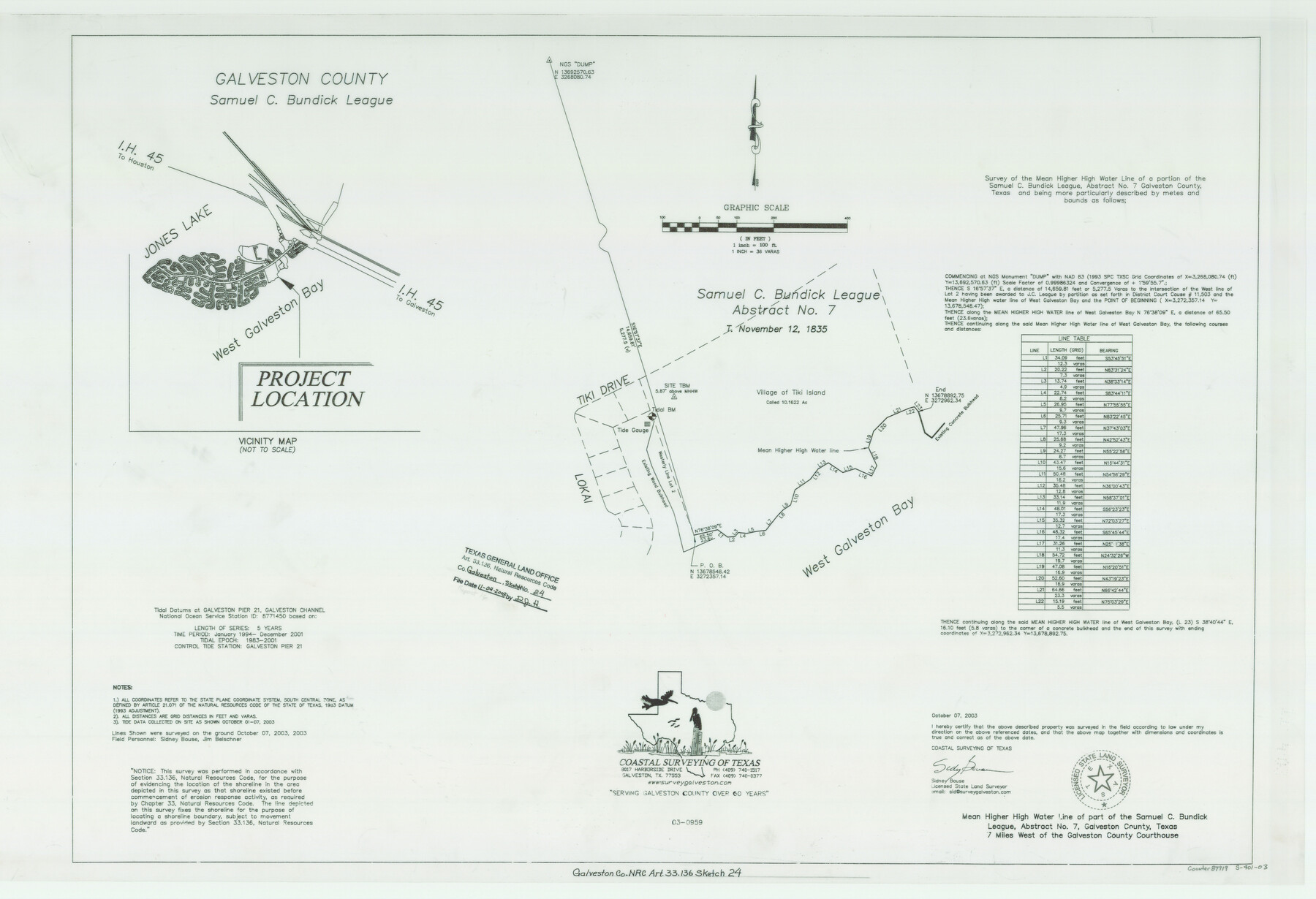
Galveston County NRC Article 33.136 Sketch 24
Mean Higher High Water Line of Part of the Samuel C. Bundick League, Abstract 7
Galveston County NRC Article 33-136 Report 16
-
Map/Doc
87919
-
Collection
General Map Collection
-
Object Dates
2003/10/7 (Creation Date)
2003/11/4 (File Date)
-
People and Organizations
Coastal Surveying of Texas (Publisher)
Coastal Surveying of Texas (Printer)
Sidney Bouse (Surveyor/Engineer)
-
Counties
Galveston
-
Subjects
Surveying CBS
-
Height x Width
24.8 x 36.3 inches
63.0 x 92.2 cm
-
Medium
multi-page, multi-format
-
Comments
Survey located about seven miles South 87 degrees West of Galveston, Texas.
Part of: General Map Collection
[Map of Polk County]
![4614, [Map of Polk County], General Map Collection](https://historictexasmaps.com/wmedia_w700/maps/4614-1.tif.jpg)
Print $20.00
- Digital $50.00
[Map of Polk County]
Size 21.7 x 25.8 inches
Map/Doc 4614
Roberts County Working Sketch 19

Print $20.00
- Digital $50.00
Roberts County Working Sketch 19
1975
Size 30.7 x 39.9 inches
Map/Doc 63545
Leon County Rolled Sketch 15

Print $20.00
- Digital $50.00
Leon County Rolled Sketch 15
1979
Size 23.5 x 18.9 inches
Map/Doc 6601
Winkler County Sketch File 1 and 2

Print $64.00
- Digital $50.00
Winkler County Sketch File 1 and 2
1900
Size 8.4 x 9.2 inches
Map/Doc 40431
Archer County

Print $20.00
- Digital $50.00
Archer County
1926
Size 42.9 x 37.8 inches
Map/Doc 73070
Taylor County Working Sketch 6

Print $20.00
- Digital $50.00
Taylor County Working Sketch 6
1951
Size 35.4 x 31.9 inches
Map/Doc 69616
Brewster County Rolled Sketch 60

Print $20.00
- Digital $50.00
Brewster County Rolled Sketch 60
Size 25.0 x 37.5 inches
Map/Doc 8484
Montgomery County Working Sketch 15

Print $40.00
- Digital $50.00
Montgomery County Working Sketch 15
1934
Size 51.8 x 41.6 inches
Map/Doc 71122
Wise County Working Sketch 20

Print $20.00
- Digital $50.00
Wise County Working Sketch 20
1979
Size 22.8 x 27.3 inches
Map/Doc 72634
Marion County Rolled Sketch 3

Print $20.00
- Digital $50.00
Marion County Rolled Sketch 3
1955
Size 35.4 x 35.5 inches
Map/Doc 9490
Jefferson County Rolled Sketch 59

Print $40.00
- Digital $50.00
Jefferson County Rolled Sketch 59
1898
Size 30.0 x 59.4 inches
Map/Doc 9313
Falls County Sketch File 16

Print $8.00
- Digital $50.00
Falls County Sketch File 16
Size 13.3 x 8.5 inches
Map/Doc 22374
You may also like
Roberts County Boundary File 2d

Print $20.00
- Digital $50.00
Roberts County Boundary File 2d
Size 9.1 x 28.1 inches
Map/Doc 58366
Newton County Rolled Sketch JFB

Print $20.00
- Digital $50.00
Newton County Rolled Sketch JFB
Size 16.0 x 38.3 inches
Map/Doc 6858
Starr County Sketch File 38

Print $8.00
- Digital $50.00
Starr County Sketch File 38
1940
Size 14.2 x 8.8 inches
Map/Doc 36985
La Salle County Rolled Sketch 21

Print $77.00
- Digital $50.00
La Salle County Rolled Sketch 21
1955
Size 10.0 x 15.1 inches
Map/Doc 46461
Donley County Sketch File 16

Print $4.00
- Digital $50.00
Donley County Sketch File 16
Size 14.6 x 8.8 inches
Map/Doc 21253

General Highway Map of Gaines County, Texas

Print $20.00
- Digital $50.00
General Highway Map of Gaines County, Texas
1951
Size 19.0 x 26.2 inches
Map/Doc 92644
Culberson County Working Sketch 76

Print $20.00
- Digital $50.00
Culberson County Working Sketch 76
1975
Size 33.4 x 43.1 inches
Map/Doc 68530
Williamson County

Print $40.00
- Digital $50.00
Williamson County
1946
Size 39.0 x 56.3 inches
Map/Doc 73326
Map of Kaufman County, Texas

Print $20.00
- Digital $50.00
Map of Kaufman County, Texas
Size 29.7 x 38.7 inches
Map/Doc 91029
Calhoun County Rolled Sketch 11

Print $20.00
- Digital $50.00
Calhoun County Rolled Sketch 11
1942
Size 12.8 x 41.9 inches
Map/Doc 5368
Bexar County Sketch File 56

Print $40.00
- Digital $50.00
Bexar County Sketch File 56
1966
Size 19.7 x 23.8 inches
Map/Doc 10927