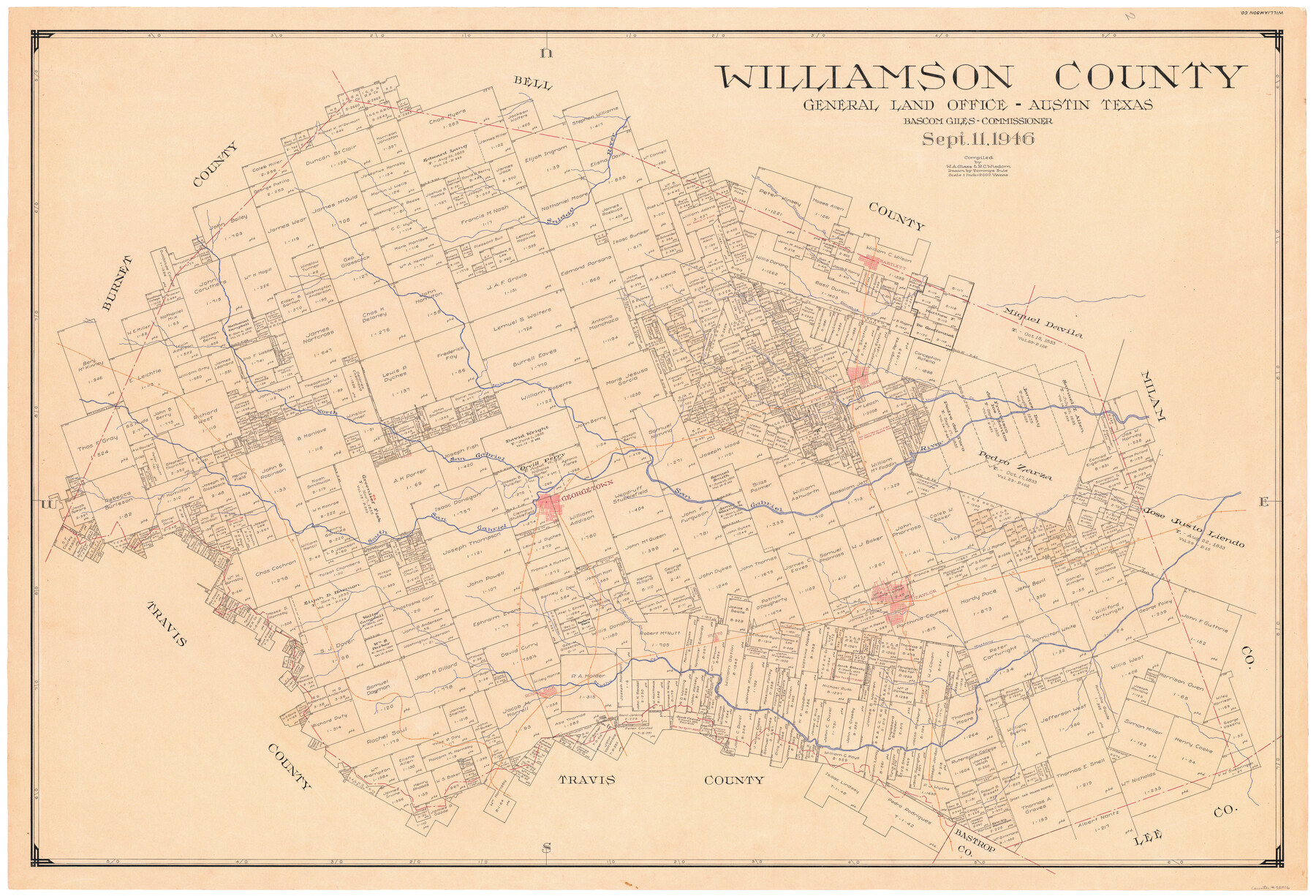
Williamson County
-
Map/Doc
73326
-
Collection
General Map Collection
-
Object Dates
1946/9/11 (Creation Date)
-
People and Organizations
Texas General Land Office (Publisher)
Tommye Buie (Draftsman)
Bascom Giles (GLO Commissioner)
W.A. Glass (Compiler)
R.C. Wisdom (Compiler)
-
Counties
Williamson
-
Subjects
County
-
Height x Width
39.0 x 56.3 inches
99.1 x 143.0 cm
-
Comments
Hand lettered.
Note on reverse side: "Compilation completed September 11, 1946. Inking completed November 25, 1946. Tracing completed January 23, 1947. Placed in official use January 23, 1947. Replaced [on sticks] by copy January 28, 1947." -
Features
MK&T
Mustang Creek
South San Gabriel River
Yankee Creek
Hutto
Brushy Creek
Round Rock
McNutt Creek
Taylor
I&GN
Turkey Creek
Georgetown
San Gabriel River
North Prong of Donahoe Creek
T&NO
North San Gabriel River
Berry Creek
Williamson Creek
Granger
Middle Yankee Creek
Middle Williamson Creek
Opossum Creek
Donahoe Creek
Bartlett
Salado River
Part of: General Map Collection
Bexar County Working Sketch 20

Print $20.00
- Digital $50.00
Bexar County Working Sketch 20
1982
Size 42.4 x 43.6 inches
Map/Doc 67336
Wichita County Sketch File 28

Print $22.00
- Digital $50.00
Wichita County Sketch File 28
1929
Size 12.5 x 17.0 inches
Map/Doc 40130
Schleicher County Rolled Sketch 10

Print $20.00
- Digital $50.00
Schleicher County Rolled Sketch 10
Size 30.1 x 25.8 inches
Map/Doc 7753
Red River County Working Sketch 26

Print $20.00
- Digital $50.00
Red River County Working Sketch 26
1961
Size 30.9 x 31.6 inches
Map/Doc 72009
Midland County Rolled Sketch REE

Print $20.00
- Digital $50.00
Midland County Rolled Sketch REE
1937
Size 27.1 x 24.3 inches
Map/Doc 6771
Menard County Sketch File 22

Print $8.00
- Digital $50.00
Menard County Sketch File 22
1927
Size 7.4 x 8.6 inches
Map/Doc 31553
Smith County Working Sketch 12

Print $20.00
- Digital $50.00
Smith County Working Sketch 12
1961
Size 30.3 x 30.6 inches
Map/Doc 63897
The Dawn of Humans Peopling of the Americas

The Dawn of Humans Peopling of the Americas
2000
Size 31.3 x 20.5 inches
Map/Doc 96841
Sutton County Sketch File 23

Print $30.00
- Digital $50.00
Sutton County Sketch File 23
1918
Size 14.2 x 8.5 inches
Map/Doc 37461
Menard County Sketch File 27

Print $8.00
- Digital $50.00
Menard County Sketch File 27
1943
Size 11.2 x 8.8 inches
Map/Doc 31564
Brazoria County NRC Article 33.136 Sketch 26

Print $24.00
Brazoria County NRC Article 33.136 Sketch 26
2025
Map/Doc 97471
Kinney County Sketch File 35

Print $6.00
- Digital $50.00
Kinney County Sketch File 35
1944
Size 14.2 x 8.7 inches
Map/Doc 29185
You may also like
International Railroad Map & Profile of the First Fifty Miles East of Brazos River

Print $40.00
- Digital $50.00
International Railroad Map & Profile of the First Fifty Miles East of Brazos River
1877
Size 19.5 x 84.9 inches
Map/Doc 64463
Bastrop County Sketch File 6

Print $4.00
- Digital $50.00
Bastrop County Sketch File 6
1875
Size 8.8 x 7.8 inches
Map/Doc 14050
Motley County Boundary File 1

Print $46.00
- Digital $50.00
Motley County Boundary File 1
Size 9.0 x 4.1 inches
Map/Doc 57488
Shelby County Working Sketch Graphic Index

Print $20.00
- Digital $50.00
Shelby County Working Sketch Graphic Index
1945
Size 42.9 x 44.3 inches
Map/Doc 76697
Current Miscellaneous File 34

Print $10.00
- Digital $50.00
Current Miscellaneous File 34
1953
Size 14.1 x 8.7 inches
Map/Doc 73942
Ward County Sketch File 12

Print $4.00
- Digital $50.00
Ward County Sketch File 12
Size 14.3 x 8.8 inches
Map/Doc 39638
Motley County

Print $20.00
- Digital $50.00
Motley County
1966
Size 41.2 x 32.1 inches
Map/Doc 77380
Foard County Boundary File 3

Print $48.00
- Digital $50.00
Foard County Boundary File 3
Size 24.2 x 6.0 inches
Map/Doc 53516
El Paso County Working Sketch Graphic Index - south part

Print $20.00
- Digital $50.00
El Paso County Working Sketch Graphic Index - south part
1977
Size 33.4 x 44.9 inches
Map/Doc 76537
Flight Mission No. DQN-1K, Frame 156, Calhoun County

Print $20.00
- Digital $50.00
Flight Mission No. DQN-1K, Frame 156, Calhoun County
1953
Size 18.6 x 22.3 inches
Map/Doc 84215
Sketch Showing Lands Conveyed to Texas State Park Board by the City of Lubbock, Texas for the Location of MacKenzie State Park

Print $20.00
- Digital $50.00
Sketch Showing Lands Conveyed to Texas State Park Board by the City of Lubbock, Texas for the Location of MacKenzie State Park
1935
Size 26.4 x 33.1 inches
Map/Doc 92724
Isogonic Chart for 1950, United States. Including Isoporic Lines

Print $20.00
- Digital $50.00
Isogonic Chart for 1950, United States. Including Isoporic Lines
1950
Size 32.2 x 47.2 inches
Map/Doc 75921