Morris County Rolled Sketch 2A
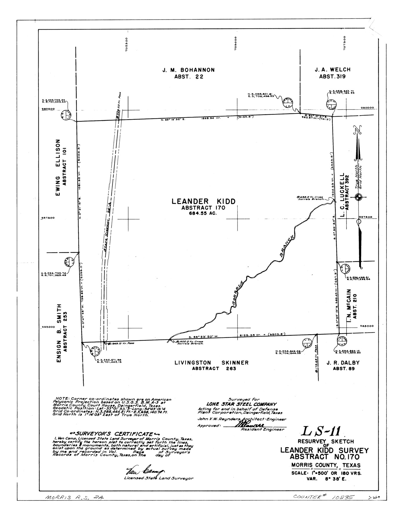
LS-11 - Resurvey sketch of Leander Kidd survey, abstract no. 170, Morris County, Texas
-
Map/Doc
10235
-
Collection
General Map Collection
-
People and Organizations
Van Camp (Surveyor/Engineer)
-
Counties
Morris
-
Subjects
Surveying Rolled Sketch
-
Height x Width
24.0 x 18.6 inches
61.0 x 47.2 cm
-
Medium
linen, manuscript
-
Scale
1" = 180 varas
-
Comments
See Morris County Rolled Sketch 2 (9550) for map of all retracement surveys made for Lone Star Steel Company.
Related maps
Morris County Rolled Sketch 2

Print $40.00
- Digital $50.00
Morris County Rolled Sketch 2
1944
Size 59.4 x 43.5 inches
Map/Doc 9550
Part of: General Map Collection
Olney's School Atlas

Print $326.00
- Digital $50.00
Olney's School Atlas
1844
Size 12.3 x 10.0 inches
Map/Doc 93534
Comanche County Working Sketch 15

Print $20.00
- Digital $50.00
Comanche County Working Sketch 15
1964
Size 20.3 x 25.5 inches
Map/Doc 68149
[Right of Way & Track Map, The Texas & Pacific Ry. Co. Main Line]
![64673, [Right of Way & Track Map, The Texas & Pacific Ry. Co. Main Line], General Map Collection](https://historictexasmaps.com/wmedia_w700/maps/64673.tif.jpg)
Print $20.00
- Digital $50.00
[Right of Way & Track Map, The Texas & Pacific Ry. Co. Main Line]
Size 11.2 x 18.6 inches
Map/Doc 64673
Galveston County NRC Article 33.136 Sketch 27

Print $126.00
- Digital $50.00
Galveston County NRC Article 33.136 Sketch 27
2003
Size 24.4 x 36.2 inches
Map/Doc 81970
Gillespie County Rolled Sketch 8

Print $20.00
- Digital $50.00
Gillespie County Rolled Sketch 8
2008
Size 20.2 x 19.1 inches
Map/Doc 89014
Goliad County Sketch File 42a

Print $4.00
- Digital $50.00
Goliad County Sketch File 42a
1845
Size 13.3 x 8.2 inches
Map/Doc 24353
Reagan County Sketch File 21

Print $20.00
- Digital $50.00
Reagan County Sketch File 21
1939
Size 31.1 x 31.3 inches
Map/Doc 10585
Galveston County Rolled Sketch S

Print $20.00
- Digital $50.00
Galveston County Rolled Sketch S
1935
Size 36.0 x 46.8 inches
Map/Doc 9088
Knox County Working Sketch Graphic Index

Print $20.00
- Digital $50.00
Knox County Working Sketch Graphic Index
1923
Size 44.8 x 39.4 inches
Map/Doc 76611
Flight Mission No. BRA-7M, Frame 204, Jefferson County

Print $20.00
- Digital $50.00
Flight Mission No. BRA-7M, Frame 204, Jefferson County
1953
Size 18.6 x 22.3 inches
Map/Doc 85572
Old Miscellaneous File 13

Print $6.00
- Digital $50.00
Old Miscellaneous File 13
1899
Size 9.7 x 6.5 inches
Map/Doc 75446
Amistad International Reservoir on Rio Grande 102

Print $20.00
- Digital $50.00
Amistad International Reservoir on Rio Grande 102
1950
Size 28.5 x 41.2 inches
Map/Doc 75533
You may also like
Leon County Working Sketch 59

Print $20.00
- Digital $50.00
Leon County Working Sketch 59
1998
Size 19.2 x 25.5 inches
Map/Doc 70459
Ector County Working Sketch 12

Print $20.00
- Digital $50.00
Ector County Working Sketch 12
1954
Size 43.3 x 20.1 inches
Map/Doc 68855
Calhoun County Sketch File 7

Print $12.00
- Digital $50.00
Calhoun County Sketch File 7
1947
Size 14.5 x 8.9 inches
Map/Doc 35925
Baylor County Sketch File 6a

Print $6.00
- Digital $50.00
Baylor County Sketch File 6a
1887
Size 10.8 x 8.1 inches
Map/Doc 14132
Mississippi River to Galveston

Print $40.00
- Digital $50.00
Mississippi River to Galveston
1973
Size 37.2 x 51.2 inches
Map/Doc 69946
Montague County Boundary File 2c

Print $44.00
- Digital $50.00
Montague County Boundary File 2c
Size 9.0 x 14.5 inches
Map/Doc 57419
Schleicher County Sketch File 18

Print $20.00
- Digital $50.00
Schleicher County Sketch File 18
Size 15.1 x 25.0 inches
Map/Doc 12300
Hunt County Boundary File 10b

Print $4.00
- Digital $50.00
Hunt County Boundary File 10b
Size 11.3 x 8.9 inches
Map/Doc 55264
Webb County Sketch File 14-1

Print $6.00
- Digital $50.00
Webb County Sketch File 14-1
1892
Size 14.4 x 9.1 inches
Map/Doc 39814
Map of Fort Bend Co.

Print $20.00
- Digital $50.00
Map of Fort Bend Co.
1906
Size 38.4 x 43.8 inches
Map/Doc 87154

[Capitol Leagues 217-228, 238, and vicinity]
![90695, [Capitol Leagues 217-228, 238, and vicinity], Twichell Survey Records](https://historictexasmaps.com/wmedia_w700/maps/90695-1.tif.jpg)
Print $20.00
- Digital $50.00
[Capitol Leagues 217-228, 238, and vicinity]
Size 23.8 x 12.9 inches
Map/Doc 90695