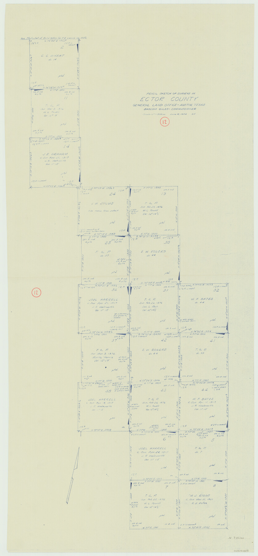
Ector County Working Sketch 12
-
Map/Doc
68855
-
Collection
General Map Collection
-
Object Dates
6/10/1954 (Creation Date)
-
People and Organizations
Herman Forbes (Draftsman)
-
Counties
Ector
-
Subjects
Surveying Working Sketch
-
Height x Width
43.3 x 20.1 inches
110.0 x 51.1 cm
-
Scale
1" = 500 varas
Part of: General Map Collection
Railroad Track Map, H&TCRRCo., Falls County, Texas

Print $4.00
- Digital $50.00
Railroad Track Map, H&TCRRCo., Falls County, Texas
1918
Size 11.7 x 18.5 inches
Map/Doc 62854
Map of Clear Lake Shores

Print $20.00
- Digital $50.00
Map of Clear Lake Shores
1927
Size 36.9 x 46.2 inches
Map/Doc 4843
[Sketch for Mineral Application 27670 - Strip between Simon Sanchez leagues and Trinity River]
![2865, [Sketch for Mineral Application 27670 - Strip between Simon Sanchez leagues and Trinity River], General Map Collection](https://historictexasmaps.com/wmedia_w700/maps/2865-1.tif.jpg)
Print $40.00
- Digital $50.00
[Sketch for Mineral Application 27670 - Strip between Simon Sanchez leagues and Trinity River]
1934
Size 17.3 x 50.5 inches
Map/Doc 2865
Stephens County Sketch File 4

Print $4.00
- Digital $50.00
Stephens County Sketch File 4
Size 7.9 x 12.1 inches
Map/Doc 37017
Gulf of Mexico

Print $20.00
- Digital $50.00
Gulf of Mexico
1908
Size 18.3 x 28.0 inches
Map/Doc 72661
Wharton County Boundary File 1b

Print $20.00
- Digital $50.00
Wharton County Boundary File 1b
Size 15.1 x 26.6 inches
Map/Doc 59855
Hispania Nova

Print $20.00
- Digital $50.00
Hispania Nova
1597
Size 12.0 x 14.9 inches
Map/Doc 94120
Statement of Facts - State of Texas vs. F. B. Olcott, Cause 17090, 12/18/1902

Print $2.00
- Digital $50.00
Statement of Facts - State of Texas vs. F. B. Olcott, Cause 17090, 12/18/1902
1902
Size 14.3 x 8.9 inches
Map/Doc 65724
Crockett County Working Sketch 77

Print $40.00
- Digital $50.00
Crockett County Working Sketch 77
1966
Size 29.6 x 58.5 inches
Map/Doc 68410
Loving County Rolled Sketch 2

Print $40.00
- Digital $50.00
Loving County Rolled Sketch 2
1952
Size 42.4 x 70.4 inches
Map/Doc 9462
Shackelford County Sketch File 17

Print $4.00
Shackelford County Sketch File 17
2009
Size 14.0 x 8.5 inches
Map/Doc 89230
Collin County

Print $20.00
- Digital $50.00
Collin County
1975
Size 42.2 x 39.4 inches
Map/Doc 77242
You may also like
Map of the Houston & Great Northern Railroad

Print $40.00
- Digital $50.00
Map of the Houston & Great Northern Railroad
1871
Size 26.2 x 87.5 inches
Map/Doc 64471
Stonewall County Rolled Sketch 7

Print $20.00
- Digital $50.00
Stonewall County Rolled Sketch 7
1890
Size 16.6 x 37.9 inches
Map/Doc 7864
Hidalgo County Sketch File 16

Print $12.00
- Digital $50.00
Hidalgo County Sketch File 16
1914
Size 11.2 x 8.9 inches
Map/Doc 26437
Taylor County Boundary File 1

Print $44.00
- Digital $50.00
Taylor County Boundary File 1
Size 8.4 x 8.2 inches
Map/Doc 59184
Medina County Working Sketch 2

Print $20.00
- Digital $50.00
Medina County Working Sketch 2
1942
Size 30.3 x 31.0 inches
Map/Doc 70917

Americae Sive Novi Orbis Nova Descriptio

Print $20.00
- Digital $50.00
Americae Sive Novi Orbis Nova Descriptio
1606
Size 16.5 x 22.4 inches
Map/Doc 93810
Cottle County Working Sketch 11

Print $20.00
- Digital $50.00
Cottle County Working Sketch 11
1943
Size 19.2 x 24.1 inches
Map/Doc 68321
Donley County Sketch File 18 (2a)

Print $2.00
- Digital $50.00
Donley County Sketch File 18 (2a)
Size 10.3 x 8.0 inches
Map/Doc 21255


Flight Mission No. DQN-1K, Frame 77, Calhoun County

Print $20.00
- Digital $50.00
Flight Mission No. DQN-1K, Frame 77, Calhoun County
1953
Size 18.5 x 22.2 inches
Map/Doc 84162