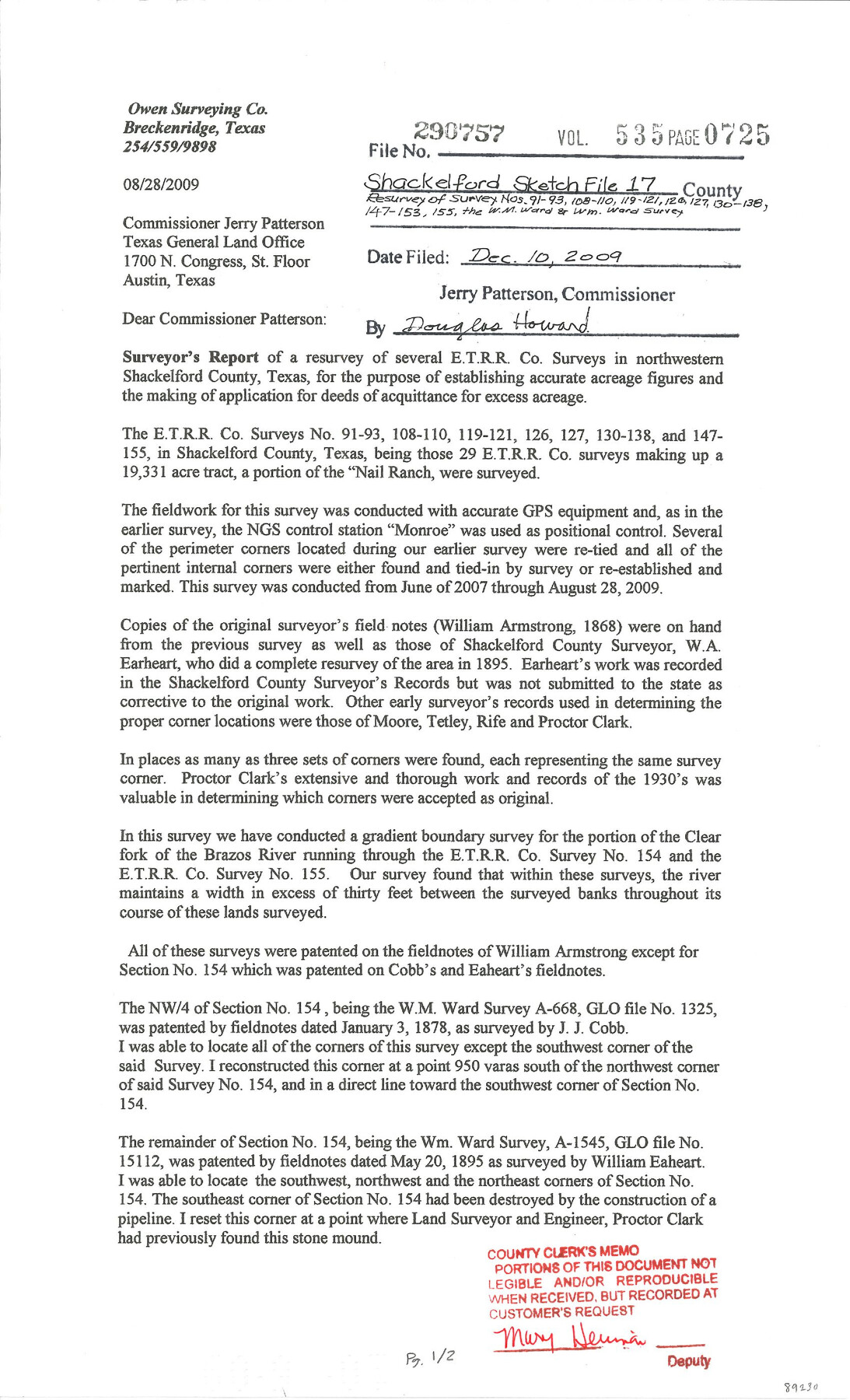
Shackelford County Sketch File 17
[Surveyor's report of a resurvey of several E. T. R.R. Co. surveys in northwestern Shackelford County]
-
Map/Doc
89230
-
Collection
General Map Collection
-
Object Dates
8/28/2009 (Creation Date)
12/10/2009 (File Date)
-
People and Organizations
Cody Owen (Surveyor/Engineer)
-
Counties
Shackelford
-
Subjects
Surveying Sketch File
-
Height x Width
14.0 x 8.5 inches
35.6 x 21.6 cm
-
Medium
paper, print
Part of: General Map Collection
Hutchinson County Sketch File 47

Print $28.00
- Digital $50.00
Hutchinson County Sketch File 47
1958
Size 8.3 x 10.1 inches
Map/Doc 27390
Jefferson County Sketch File 14

Print $60.00
- Digital $50.00
Jefferson County Sketch File 14
Size 15.8 x 13.2 inches
Map/Doc 28149
Aransas County Sketch File 21c

Print $4.00
- Digital $50.00
Aransas County Sketch File 21c
Size 8.7 x 14.0 inches
Map/Doc 13162
Liberty County Sketch File 45

Print $4.00
- Digital $50.00
Liberty County Sketch File 45
Size 7.8 x 10.1 inches
Map/Doc 30003
Pecos County Working Sketch 17

Print $20.00
- Digital $50.00
Pecos County Working Sketch 17
1915
Size 32.5 x 23.0 inches
Map/Doc 71487
Crockett County Rolled Sketch 55

Print $40.00
- Digital $50.00
Crockett County Rolled Sketch 55
Size 42.3 x 95.8 inches
Map/Doc 8718
Flight Mission No. DQN-7K, Frame 33, Calhoun County

Print $20.00
- Digital $50.00
Flight Mission No. DQN-7K, Frame 33, Calhoun County
1953
Size 18.5 x 22.1 inches
Map/Doc 84471
San Jacinto County Working Sketch 34

Print $20.00
- Digital $50.00
San Jacinto County Working Sketch 34
1955
Size 25.2 x 25.2 inches
Map/Doc 63747
Map of Houston & Overton Branch Railroad

Print $40.00
- Digital $50.00
Map of Houston & Overton Branch Railroad
1877
Size 22.3 x 110.1 inches
Map/Doc 64460
Crockett County Working Sketch 56

Print $20.00
- Digital $50.00
Crockett County Working Sketch 56
1947
Size 28.5 x 46.7 inches
Map/Doc 68389
Oldham County Working Sketch 1

Print $20.00
- Digital $50.00
Oldham County Working Sketch 1
1901
Size 40.2 x 24.7 inches
Map/Doc 71323
Wilbarger County Sketch File 25

Print $6.00
- Digital $50.00
Wilbarger County Sketch File 25
Size 11.0 x 16.7 inches
Map/Doc 40225
You may also like
[Movements & Objectives of the 143rd & 144th Infantry on October 9-11, 1918, Appendix E, Nos.2 and 3] - Verso
![94132, [Movements & Objectives of the 143rd & 144th Infantry on October 9-11, 1918, Appendix E, Nos.2 and 3] - Verso, Non-GLO Digital Images](https://historictexasmaps.com/wmedia_w700/maps/94132-1.tif.jpg)
Print $20.00
[Movements & Objectives of the 143rd & 144th Infantry on October 9-11, 1918, Appendix E, Nos.2 and 3] - Verso
1918
Size 41.9 x 20.2 inches
Map/Doc 94132
Lamb County Boundary File 1

Print $10.00
- Digital $50.00
Lamb County Boundary File 1
Size 11.1 x 8.5 inches
Map/Doc 56027
Refugio County Boundary File 4

Print $28.00
- Digital $50.00
Refugio County Boundary File 4
Size 14.0 x 8.8 inches
Map/Doc 58251
Montgomery County Working Sketch 51

Print $20.00
- Digital $50.00
Montgomery County Working Sketch 51
1960
Size 38.7 x 40.4 inches
Map/Doc 71158
Coryell County Working Sketch 13

Print $20.00
- Digital $50.00
Coryell County Working Sketch 13
1950
Size 20.9 x 22.7 inches
Map/Doc 68220
Leon County Working Sketch 42

Print $40.00
- Digital $50.00
Leon County Working Sketch 42
1980
Size 56.8 x 42.8 inches
Map/Doc 70441
Hutchinson County, 1922

Print $20.00
- Digital $50.00
Hutchinson County, 1922
1922
Size 36.4 x 43.7 inches
Map/Doc 89700
Tracing of J. M. Morgan's Map Showing X-LIT Fence Line

Print $20.00
- Digital $50.00
Tracing of J. M. Morgan's Map Showing X-LIT Fence Line
1916
Size 9.5 x 22.7 inches
Map/Doc 91809
Motley County

Print $20.00
- Digital $50.00
Motley County
1966
Size 44.8 x 35.8 inches
Map/Doc 95597
University Land Field Notes for Block 35 in Crane and Ector Counties

University Land Field Notes for Block 35 in Crane and Ector Counties
Map/Doc 81714
[Capitol Leagues in Lamb County]
![91015, [Capitol Leagues in Lamb County], Twichell Survey Records](https://historictexasmaps.com/wmedia_w700/maps/91015-1.tif.jpg)
Print $2.00
- Digital $50.00
[Capitol Leagues in Lamb County]
1912
Size 12.3 x 8.8 inches
Map/Doc 91015
Atascosa County

Print $40.00
- Digital $50.00
Atascosa County
1894
Size 50.5 x 44.1 inches
Map/Doc 66706