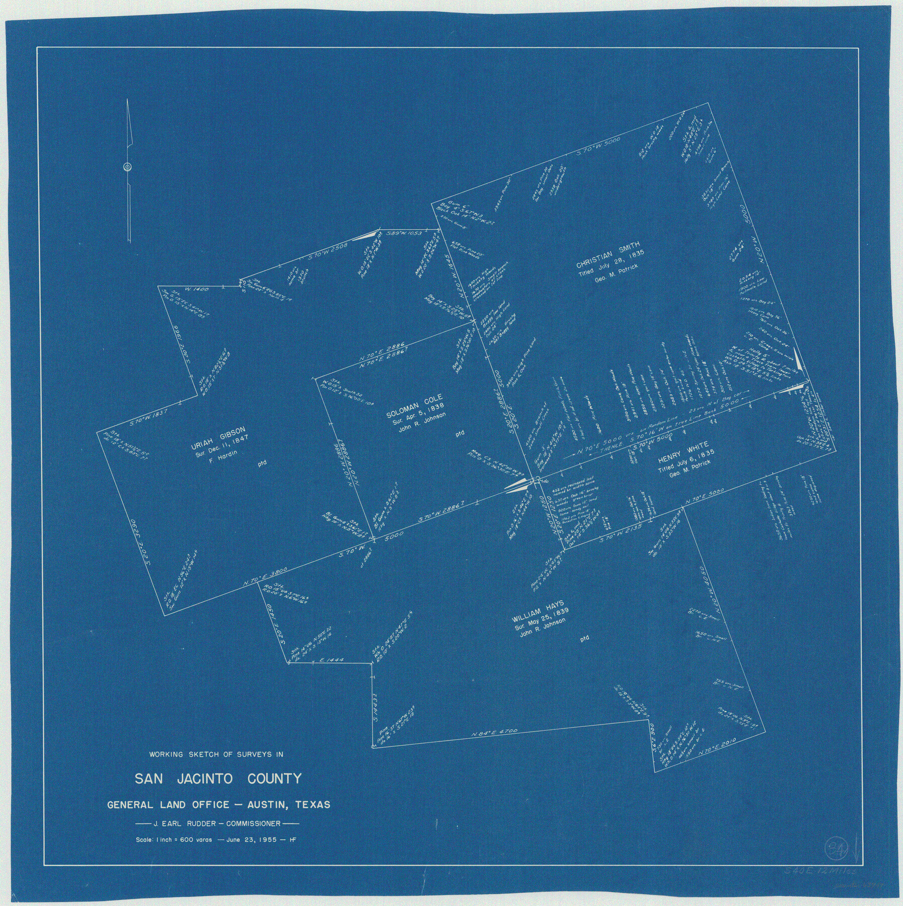
San Jacinto County Working Sketch 34
-
Map/Doc
63747
-
Collection
General Map Collection
-
Counties
San Jacinto
-
Subjects
Cadastral Surveying Working Sketch
-
Height x Width
25.2 x 25.2 inches
64.0 x 64.0 cm
Part of: General Map Collection
Wichita County Rolled Sketch 5
![8242, Wichita County Rolled Sketch 5, General Map Collection](https://historictexasmaps.com/wmedia_w700/maps/8242.tif.jpg)
Print $20.00
- Digital $50.00
Wichita County Rolled Sketch 5
Size 24.1 x 39.2 inches
Map/Doc 8242
Scurry County Working Sketch 3
![63832, Scurry County Working Sketch 3, General Map Collection](https://historictexasmaps.com/wmedia_w700/maps/63832.tif.jpg)
Print $20.00
- Digital $50.00
Scurry County Working Sketch 3
Size 20.7 x 12.4 inches
Map/Doc 63832
Map of Bell County
![829, Map of Bell County, General Map Collection](https://historictexasmaps.com/wmedia_w700/maps/0829.tif.jpg)
Print $20.00
- Digital $50.00
Map of Bell County
1855
Size 19.2 x 24.4 inches
Map/Doc 829
Current Miscellaneous File 21
![73865, Current Miscellaneous File 21, General Map Collection](https://historictexasmaps.com/wmedia_w700/pdf_converted_jpg/qi_pdf_thumbnail_27666.jpg)
Print $26.00
- Digital $50.00
Current Miscellaneous File 21
1952
Size 10.8 x 8.2 inches
Map/Doc 73865
Copy of Surveyor's Field Book, Morris Browning - In Blocks 7, 5 & 4, I&GNRRCo., Hutchinson and Carson Counties, Texas
![62260, Copy of Surveyor's Field Book, Morris Browning - In Blocks 7, 5 & 4, I&GNRRCo., Hutchinson and Carson Counties, Texas, General Map Collection](https://historictexasmaps.com/wmedia_w700/maps/62260.tif.jpg)
Print $2.00
- Digital $50.00
Copy of Surveyor's Field Book, Morris Browning - In Blocks 7, 5 & 4, I&GNRRCo., Hutchinson and Carson Counties, Texas
1888
Size 6.9 x 8.8 inches
Map/Doc 62260
Cameron County Rolled Sketch 28
![8575, Cameron County Rolled Sketch 28, General Map Collection](https://historictexasmaps.com/wmedia_w700/maps/8575.tif.jpg)
Print $40.00
- Digital $50.00
Cameron County Rolled Sketch 28
1986
Size 36.5 x 48.3 inches
Map/Doc 8575
Chambers County Rolled Sketch 20
![43987, Chambers County Rolled Sketch 20, General Map Collection](https://historictexasmaps.com/wmedia_w700/pdf_converted_jpg/qi_pdf_thumbnail_15422.jpg)
Print $1171.00
- Digital $50.00
Chambers County Rolled Sketch 20
Size 10.7 x 16.2 inches
Map/Doc 43987
Jefferson County Working Sketch 43
![73591, Jefferson County Working Sketch 43, General Map Collection](https://historictexasmaps.com/wmedia_w700/maps/73591.tif.jpg)
Print $20.00
- Digital $50.00
Jefferson County Working Sketch 43
1960
Size 42.7 x 31.1 inches
Map/Doc 73591
El Paso County Boundary File 23
![53218, El Paso County Boundary File 23, General Map Collection](https://historictexasmaps.com/wmedia_w700/pdf_converted_jpg/qi_pdf_thumbnail_15993.jpg)
Print $9.00
- Digital $50.00
El Paso County Boundary File 23
Size 14.9 x 9.4 inches
Map/Doc 53218
Flight Mission No. BQR-7K, Frame 25, Brazoria County
![84023, Flight Mission No. BQR-7K, Frame 25, Brazoria County, General Map Collection](https://historictexasmaps.com/wmedia_w700/pdf_converted_jpg/qi_pdf_thumbnail_31242.jpg)
Print $20.00
- Digital $50.00
Flight Mission No. BQR-7K, Frame 25, Brazoria County
1952
Size 18.8 x 22.3 inches
Map/Doc 84023
Zavalla County
![4645, Zavalla County, General Map Collection](https://historictexasmaps.com/wmedia_w700/maps/4645.tif.jpg)
Print $20.00
- Digital $50.00
Zavalla County
1879
Size 21.3 x 25.0 inches
Map/Doc 4645
Flight Mission No. DQN-2K, Frame 76, Calhoun County
![84268, Flight Mission No. DQN-2K, Frame 76, Calhoun County, General Map Collection](https://historictexasmaps.com/wmedia_w700/pdf_converted_jpg/qi_pdf_thumbnail_31485.jpg)
Print $20.00
- Digital $50.00
Flight Mission No. DQN-2K, Frame 76, Calhoun County
1953
Size 18.8 x 22.3 inches
Map/Doc 84268
You may also like
North Half, Harris County, Texas - Ownership Map with Well Data
![93206, North Half, Harris County, Texas - Ownership Map with Well Data, Twichell Survey Records](https://historictexasmaps.com/wmedia_w700/maps/93206.tif.jpg)
North Half, Harris County, Texas - Ownership Map with Well Data
1948
Size 121.9 x 44.3 inches
Map/Doc 93206
Marion County Working Sketch 34
![70810, Marion County Working Sketch 34, General Map Collection](https://historictexasmaps.com/wmedia_w700/maps/70810.tif.jpg)
Print $20.00
- Digital $50.00
Marion County Working Sketch 34
Size 45.2 x 23.2 inches
Map/Doc 70810
Ellis County Boundary File 3
![52950, Ellis County Boundary File 3, General Map Collection](https://historictexasmaps.com/wmedia_w700/pdf_converted_jpg/qi_pdf_thumbnail_15959.jpg)
Print $58.00
- Digital $50.00
Ellis County Boundary File 3
Size 14.1 x 122.4 inches
Map/Doc 52950
General Highway Map, Blanco County, Texas
![79020, General Highway Map, Blanco County, Texas, Texas State Library and Archives](https://historictexasmaps.com/wmedia_w700/maps/79020.tif.jpg)
Print $20.00
General Highway Map, Blanco County, Texas
1940
Size 25.0 x 18.5 inches
Map/Doc 79020
Map of section no. 4 of a survey of Padre Island made for the Office of the Attorney General of the State of Texas
![2260, Map of section no. 4 of a survey of Padre Island made for the Office of the Attorney General of the State of Texas, General Map Collection](https://historictexasmaps.com/wmedia_w700/maps/2260.tif.jpg)
Print $40.00
- Digital $50.00
Map of section no. 4 of a survey of Padre Island made for the Office of the Attorney General of the State of Texas
1941
Size 82.6 x 40.8 inches
Map/Doc 2260
Aransas County NRC Article 33.136 Sketch 2
![61643, Aransas County NRC Article 33.136 Sketch 2, General Map Collection](https://historictexasmaps.com/wmedia_w700/pdf_converted_jpg/qi_pdf_thumbnail_17184.jpg)
Print $26.00
- Digital $50.00
Aransas County NRC Article 33.136 Sketch 2
2001
Size 18.6 x 24.2 inches
Map/Doc 61643
Famous Heights Addn. Amarillo, Texas
![91700, Famous Heights Addn. Amarillo, Texas, Twichell Survey Records](https://historictexasmaps.com/wmedia_w700/maps/91700-1.tif.jpg)
Print $2.00
- Digital $50.00
Famous Heights Addn. Amarillo, Texas
Size 8.3 x 9.8 inches
Map/Doc 91700
Midland County Working Sketch 34
![71015, Midland County Working Sketch 34, General Map Collection](https://historictexasmaps.com/wmedia_w700/maps/71015.tif.jpg)
Print $20.00
- Digital $50.00
Midland County Working Sketch 34
Size 42.2 x 38.3 inches
Map/Doc 71015
Shackelford County Sketch File 6
![81981, Shackelford County Sketch File 6, General Map Collection](https://historictexasmaps.com/wmedia_w700/pdf_converted_jpg/qi_pdf_thumbnail_30499.jpg)
Print $20.00
- Digital $50.00
Shackelford County Sketch File 6
Size 14.8 x 24.5 inches
Map/Doc 81981
General Highway Map, Kendall County, Texas
![79153, General Highway Map, Kendall County, Texas, Texas State Library and Archives](https://historictexasmaps.com/wmedia_w700/maps/79153.tif.jpg)
Print $20.00
General Highway Map, Kendall County, Texas
1940
Size 18.4 x 24.7 inches
Map/Doc 79153
Palo Pinto County
![1394, Palo Pinto County, General Map Collection](https://historictexasmaps.com/wmedia_w700/maps/1394-1.tif.jpg)
Print $20.00
- Digital $50.00
Palo Pinto County
1856
Size 29.9 x 20.9 inches
Map/Doc 1394