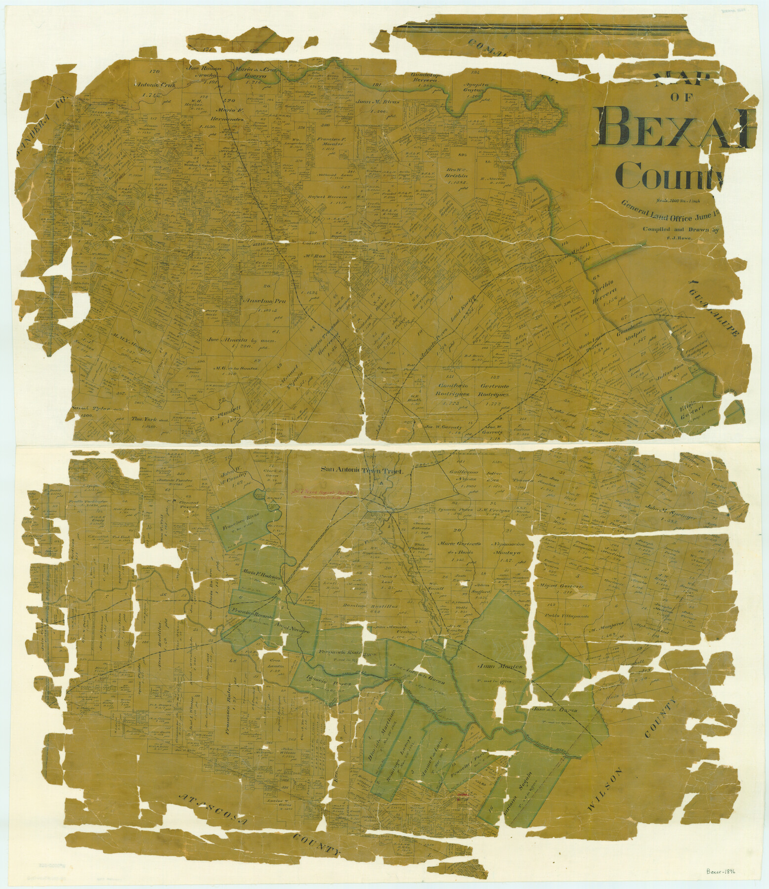
Map of Bexar County
-
Map/Doc
4766
-
Collection
General Map Collection
-
Object Dates
1896/6/1 (Creation Date)
-
People and Organizations
Texas General Land Office (Publisher)
Sidney J. Rowe (Draftsman)
Sidney J. Rowe (Compiler)
-
Counties
Bexar
-
Subjects
County
-
Height x Width
46.2 x 39.9 inches
117.3 x 101.3 cm
-
Comments
Possible date is June 1, 1896.
-
Features
San Antonio Springs
Kerr's Crossing
Leon Creek
Elm Creek
Perez Crossing
Medina River
Lasoyo's Crossing
Calaveras Creek
Leon Spring
Helotes Cr[eek]
Colebra Cr[eek]
L&GRR
Elmendorf
Martinez
GH&SA
San Pedro Springs
San Antonio River
San Pedro Creek
Calavera's Cr[eek]
Salado Cr[eek]
Leon Creek
Elm
Medina River
San Pedro Creek
Paint Road
Cibolo River
Leon Springs
Helotes Creek
Colebra Creek
I&GN
San Antonio Springs
Martinez Creek
GH&SA
San Pedro Springs
I&GN Depot
Balcones Creek
San Antonio River
GH&SA Depot
San Antonio
Mission Concepcíon
Mission San Jose
Mission Espada
Medio Creek
Salado Creek
Chupaderas Creek
Parita Creek
Part of: General Map Collection
Trinity River, Oliver Crossing Sheet/Chambers Creek

Print $6.00
- Digital $50.00
Trinity River, Oliver Crossing Sheet/Chambers Creek
1931
Size 30.1 x 28.2 inches
Map/Doc 65231
Map of the Houston & Great Northern Railroad

Print $40.00
- Digital $50.00
Map of the Houston & Great Northern Railroad
1871
Size 26.6 x 48.4 inches
Map/Doc 64472
Moore County Working Sketch 7

Print $20.00
- Digital $50.00
Moore County Working Sketch 7
1939
Size 10.8 x 17.8 inches
Map/Doc 71189
Texas City Heights being a subdivision of the east half of the Robert Logan one third league, Galveston County, Texas

Print $20.00
- Digital $50.00
Texas City Heights being a subdivision of the east half of the Robert Logan one third league, Galveston County, Texas
1895
Size 22.4 x 17.3 inches
Map/Doc 95356
Flight Mission No. DAG-23K, Frame 178, Matagorda County

Print $20.00
- Digital $50.00
Flight Mission No. DAG-23K, Frame 178, Matagorda County
1953
Size 18.8 x 22.5 inches
Map/Doc 86513
Texas State Boundary Line 4

Print $20.00
- Digital $50.00
Texas State Boundary Line 4
Size 11.2 x 8.7 inches
Map/Doc 74949
Polk County Sketch File 17

Print $4.00
- Digital $50.00
Polk County Sketch File 17
1861
Size 8.1 x 9.5 inches
Map/Doc 34163
Kinney County

Print $40.00
- Digital $50.00
Kinney County
1909
Size 48.4 x 42.7 inches
Map/Doc 16868
[Galveston, Harrisburg & San Antonio through El Paso County]
![64004, [Galveston, Harrisburg & San Antonio through El Paso County], General Map Collection](https://historictexasmaps.com/wmedia_w700/maps/64004.tif.jpg)
Print $20.00
- Digital $50.00
[Galveston, Harrisburg & San Antonio through El Paso County]
Size 13.6 x 33.6 inches
Map/Doc 64004
El Paso County Rolled Sketch EC

Print $20.00
- Digital $50.00
El Paso County Rolled Sketch EC
1912
Size 30.1 x 18.2 inches
Map/Doc 5857
Wilbarger County Working Sketch 18

Print $20.00
- Digital $50.00
Wilbarger County Working Sketch 18
1965
Size 42.0 x 46.6 inches
Map/Doc 72556
Winkler County Rolled Sketch 4

Print $40.00
- Digital $50.00
Winkler County Rolled Sketch 4
1927
Size 59.1 x 39.5 inches
Map/Doc 10147
You may also like
Flight Mission No. BRA-17M, Frame 2, Jefferson County

Print $20.00
- Digital $50.00
Flight Mission No. BRA-17M, Frame 2, Jefferson County
1953
Size 18.6 x 22.3 inches
Map/Doc 85782

Zapata County

Print $40.00
- Digital $50.00
Zapata County
1901
Size 53.1 x 38.0 inches
Map/Doc 63143
Motley County Working Sketch 5

Print $20.00
- Digital $50.00
Motley County Working Sketch 5
1940
Size 22.5 x 20.3 inches
Map/Doc 71210
Val Verde County Sketch File Z15

Print $22.00
- Digital $50.00
Val Verde County Sketch File Z15
1902
Size 15.2 x 17.2 inches
Map/Doc 39144
Galveston County NRC Article 33.136 Sketch 74

Print $26.00
- Digital $50.00
Galveston County NRC Article 33.136 Sketch 74
2013
Size 24.0 x 36.0 inches
Map/Doc 95114
Sherman County Boundary File Index

Print $2.00
- Digital $50.00
Sherman County Boundary File Index
Size 8.8 x 13.2 inches
Map/Doc 58750

El Paso County Working Sketch 6

Print $20.00
- Digital $50.00
El Paso County Working Sketch 6
1928
Size 25.4 x 16.7 inches
Map/Doc 69028
Pecos County Rolled Sketch 39A

Print $20.00
- Digital $50.00
Pecos County Rolled Sketch 39A
1908
Size 23.8 x 35.9 inches
Map/Doc 7218
Mills County Boundary File 5b

Print $8.00
- Digital $50.00
Mills County Boundary File 5b
Size 14.2 x 8.7 inches
Map/Doc 57307
Flight Mission No. BRE-1P, Frame 54, Nueces County

Print $20.00
- Digital $50.00
Flight Mission No. BRE-1P, Frame 54, Nueces County
1956
Size 18.4 x 22.2 inches
Map/Doc 86643