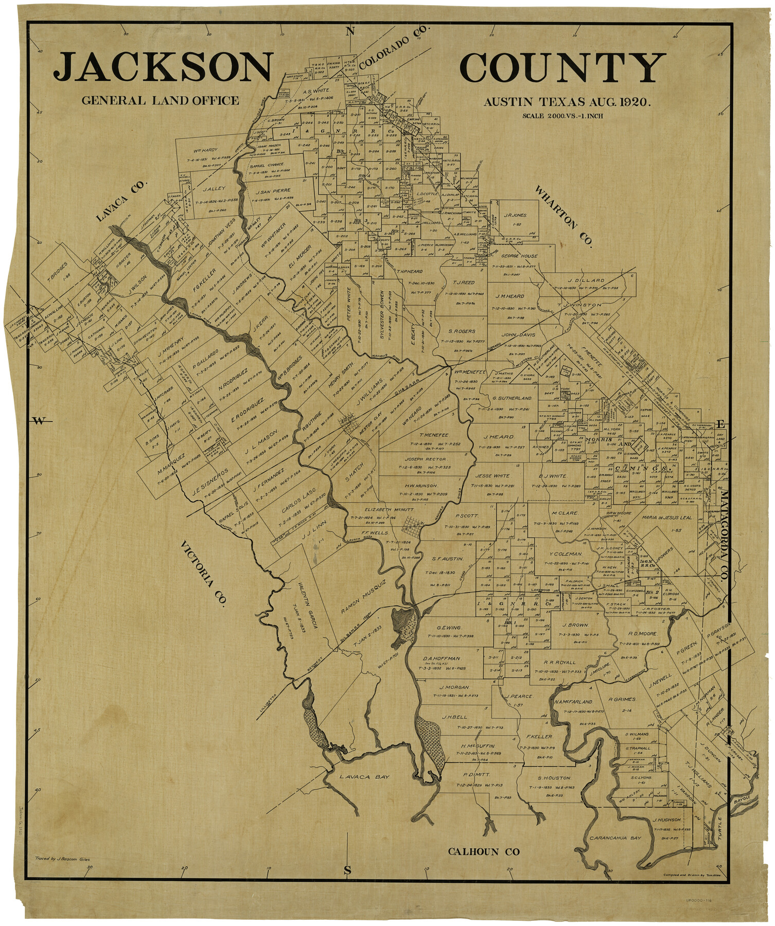
Jackson County
-
Map/Doc
4989
-
Collection
General Map Collection
-
Object Dates
8/1920 (Creation Date)
-
People and Organizations
Tom G. Atlee (Draftsman)
J. Bascom Giles (Tracer)
-
Counties
Jackson
-
Subjects
County
-
Height x Width
48.5 x 40.8 inches
123.2 x 103.6 cm
Part of: General Map Collection
Presidio County Working Sketch 99

Print $20.00
- Digital $50.00
Presidio County Working Sketch 99
1979
Size 26.8 x 39.8 inches
Map/Doc 71776
Morris County Rolled Sketch 2A

Print $20.00
- Digital $50.00
Morris County Rolled Sketch 2A
Size 22.6 x 17.7 inches
Map/Doc 10285
Flight Mission No. DQO-11K, Frame 23, Galveston County

Print $20.00
- Digital $50.00
Flight Mission No. DQO-11K, Frame 23, Galveston County
1952
Size 18.8 x 22.4 inches
Map/Doc 85220
Map of Hays County Travis District

Print $20.00
- Digital $50.00
Map of Hays County Travis District
1861
Size 18.6 x 26.0 inches
Map/Doc 3648
Presidio County Working Sketch 98

Print $20.00
- Digital $50.00
Presidio County Working Sketch 98
1978
Size 30.9 x 31.7 inches
Map/Doc 71775
Flight Mission No. CGI-1N, Frame 142, Cameron County

Print $20.00
- Digital $50.00
Flight Mission No. CGI-1N, Frame 142, Cameron County
1955
Size 18.5 x 22.2 inches
Map/Doc 84498
Brooks County Working Sketch 7

Print $20.00
- Digital $50.00
Brooks County Working Sketch 7
1928
Size 35.6 x 27.1 inches
Map/Doc 67791
Duval County Sketch File 4c1

Print $4.00
- Digital $50.00
Duval County Sketch File 4c1
1874
Size 10.4 x 7.9 inches
Map/Doc 21286
Nueces County Rolled Sketch 57

Print $48.00
Nueces County Rolled Sketch 57
1979
Size 18.9 x 24.6 inches
Map/Doc 6897
Garza County Sketch File 23

Print $6.00
- Digital $50.00
Garza County Sketch File 23
1907
Size 11.3 x 8.7 inches
Map/Doc 24080
Red River County Working Sketch 18

Print $20.00
- Digital $50.00
Red River County Working Sketch 18
1955
Size 31.1 x 34.3 inches
Map/Doc 72001
Texas City Channel, Texas, Channel and Turning Basin Dredging - Sheet 5

Print $20.00
- Digital $50.00
Texas City Channel, Texas, Channel and Turning Basin Dredging - Sheet 5
1958
Size 28.2 x 40.9 inches
Map/Doc 61835
You may also like
Kerr County Working Sketch 20

Print $20.00
- Digital $50.00
Kerr County Working Sketch 20
1960
Size 37.1 x 41.5 inches
Map/Doc 70051
Wharton County Working Sketch 1

Print $20.00
- Digital $50.00
Wharton County Working Sketch 1
Size 23.3 x 21.4 inches
Map/Doc 72465
University of Texas System University Lands

Print $20.00
- Digital $50.00
University of Texas System University Lands
Size 17.7 x 23.2 inches
Map/Doc 93242
Plat Proposed Location of Highway From Plains to Intersect Lovington Highway on New Mexico State Line

Print $20.00
- Digital $50.00
Plat Proposed Location of Highway From Plains to Intersect Lovington Highway on New Mexico State Line
Size 44.2 x 17.3 inches
Map/Doc 92856
Map of Fort Worth

Print $40.00
- Digital $50.00
Map of Fort Worth
1902
Size 61.3 x 34.8 inches
Map/Doc 93274
Jasper County Boundary File 4

Print $4.00
- Digital $50.00
Jasper County Boundary File 4
Size 14.4 x 8.9 inches
Map/Doc 55489
San Antonio & Aransas Pass RR Co., Fort Bend County, Texas

Print $20.00
- Digital $50.00
San Antonio & Aransas Pass RR Co., Fort Bend County, Texas
1898
Size 10.5 x 31.0 inches
Map/Doc 64143
Williamson County Sketch File 26

Print $30.00
- Digital $50.00
Williamson County Sketch File 26
1853
Size 14.2 x 8.8 inches
Map/Doc 40367
Colorado County Working Sketch 13

Print $20.00
- Digital $50.00
Colorado County Working Sketch 13
1943
Size 37.9 x 23.3 inches
Map/Doc 68113

Brewster County Rolled Sketch 153

Print $20.00
- Digital $50.00
Brewster County Rolled Sketch 153
Size 32.4 x 19.2 inches
Map/Doc 5320
McMullen County Working Sketch 41

Print $20.00
- Digital $50.00
McMullen County Working Sketch 41
1978
Size 32.5 x 23.9 inches
Map/Doc 70742