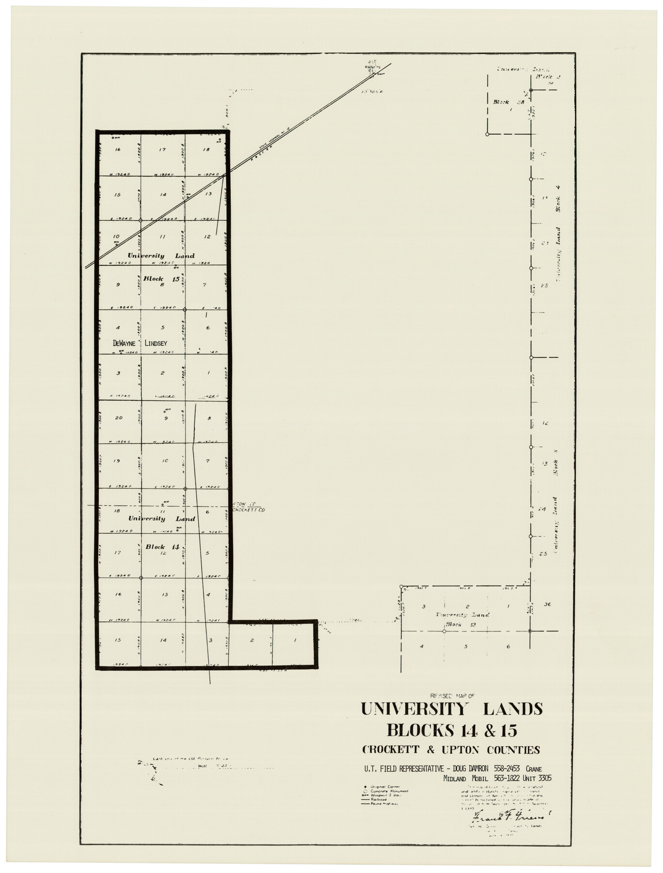
University of Texas System University Lands
-
Map/Doc
93242
-
Collection
Twichell Survey Records
-
People and Organizations
Frank F. Friend (Surveyor/Engineer)
-
Counties
Crockett Upton
-
Height x Width
17.7 x 23.2 inches
45.0 x 58.9 cm
-
Comments
See maps 93235-93251 for the full set of University Lands maps.
Related maps
University of Texas System University Lands

Print $20.00
- Digital $50.00
University of Texas System University Lands
Size 23.2 x 17.6 inches
Map/Doc 93235
University of Texas System University Lands

Print $20.00
- Digital $50.00
University of Texas System University Lands
1936
Size 23.2 x 17.6 inches
Map/Doc 93236
University of Texas System University Lands

Print $20.00
- Digital $50.00
University of Texas System University Lands
1937
Size 23.3 x 17.6 inches
Map/Doc 93237
University of Texas System University Lands

Print $20.00
- Digital $50.00
University of Texas System University Lands
Size 23.1 x 17.5 inches
Map/Doc 93238
University of Texas System University Lands

Print $20.00
- Digital $50.00
University of Texas System University Lands
1936
Size 23.1 x 17.5 inches
Map/Doc 93239
University of Texas System University Lands

Print $20.00
- Digital $50.00
University of Texas System University Lands
Size 23.0 x 17.5 inches
Map/Doc 93240
University of Texas System University Lands

Print $20.00
- Digital $50.00
University of Texas System University Lands
1931
Size 23.2 x 17.5 inches
Map/Doc 93241
University of Texas System University Lands

Print $20.00
- Digital $50.00
University of Texas System University Lands
1938
Size 23.4 x 17.9 inches
Map/Doc 93243
University of Texas System University Lands

Print $20.00
- Digital $50.00
University of Texas System University Lands
Size 17.9 x 23.3 inches
Map/Doc 93244
University of Texas System University Lands

Print $20.00
- Digital $50.00
University of Texas System University Lands
Size 17.8 x 23.4 inches
Map/Doc 93245
University of Texas System University Lands

Print $20.00
- Digital $50.00
University of Texas System University Lands
1929
Size 23.2 x 17.7 inches
Map/Doc 93246
University of Texas System University Lands

Print $20.00
- Digital $50.00
University of Texas System University Lands
1938
Size 17.8 x 23.4 inches
Map/Doc 93247
University of Texas System University Lands

Print $20.00
- Digital $50.00
University of Texas System University Lands
1933
Size 23.0 x 17.7 inches
Map/Doc 93248
University of Texas System University Lands

Print $20.00
- Digital $50.00
University of Texas System University Lands
1938
Size 17.9 x 23.5 inches
Map/Doc 93249
University of Texas System University Lands

Print $20.00
- Digital $50.00
University of Texas System University Lands
1972
Size 23.2 x 17.9 inches
Map/Doc 93250
University of Texas System University Lands

Print $20.00
- Digital $50.00
University of Texas System University Lands
Size 23.2 x 17.9 inches
Map/Doc 93251
Part of: Twichell Survey Records
P. W. Walker Seed and Grain Co. Littlefield, Texas

Print $20.00
- Digital $50.00
P. W. Walker Seed and Grain Co. Littlefield, Texas
1950
Size 36.9 x 15.8 inches
Map/Doc 92404
[G. & M. Block O, M. B. & A. Block N, PSL Blocks B-19 and B-29 showing alleged vacancy]
![89812, [G. & M. Block O, M. B. & A. Block N, PSL Blocks B-19 and B-29 showing alleged vacancy], Twichell Survey Records](https://historictexasmaps.com/wmedia_w700/maps/89812-1.tif.jpg)
Print $40.00
- Digital $50.00
[G. & M. Block O, M. B. & A. Block N, PSL Blocks B-19 and B-29 showing alleged vacancy]
Size 72.2 x 36.9 inches
Map/Doc 89812
[Blocks B5, 46, and 47]
![91189, [Blocks B5, 46, and 47], Twichell Survey Records](https://historictexasmaps.com/wmedia_w700/maps/91189-1.tif.jpg)
Print $20.00
- Digital $50.00
[Blocks B5, 46, and 47]
1886
Size 23.1 x 16.8 inches
Map/Doc 91189
Bivin's Addition to Amarillo, Texas, Survey 187, Block 2, A. B. & M., Potter County

Print $20.00
- Digital $50.00
Bivin's Addition to Amarillo, Texas, Survey 187, Block 2, A. B. & M., Potter County
Size 20.1 x 23.0 inches
Map/Doc 91739
Richland Hills Addition to Muleshoe, Bailey County, Texas

Print $20.00
- Digital $50.00
Richland Hills Addition to Muleshoe, Bailey County, Texas
1957
Size 22.9 x 31.8 inches
Map/Doc 92532
Dallam County

Print $20.00
- Digital $50.00
Dallam County
1888
Size 29.5 x 24.6 inches
Map/Doc 90654
[T. & P. R. R. Co. Blk. 33, T3N]
![90131, [T. & P. R. R. Co. Blk. 33, T3N], Twichell Survey Records](https://historictexasmaps.com/wmedia_w700/maps/90131-1.tif.jpg)
Print $2.00
- Digital $50.00
[T. & P. R. R. Co. Blk. 33, T3N]
Size 8.7 x 11.6 inches
Map/Doc 90131
[Texas Boundary Line]
![92071, [Texas Boundary Line], Twichell Survey Records](https://historictexasmaps.com/wmedia_w700/maps/92071-1.tif.jpg)
Print $20.00
- Digital $50.00
[Texas Boundary Line]
Size 21.5 x 12.0 inches
Map/Doc 92071
[Sketch of area around R. D. Price and Berry Doolittle Surveys]
![91878, [Sketch of area around R. D. Price and Berry Doolittle Surveys], Twichell Survey Records](https://historictexasmaps.com/wmedia_w700/maps/91878-1.tif.jpg)
Print $20.00
- Digital $50.00
[Sketch of area around R. D. Price and Berry Doolittle Surveys]
Size 27.4 x 19.8 inches
Map/Doc 91878
[Blocks 57, 56, 55, 54, 76, 53]
![92928, [Blocks 57, 56, 55, 54, 76, 53], Twichell Survey Records](https://historictexasmaps.com/wmedia_w700/maps/92928-1.tif.jpg)
Print $20.00
- Digital $50.00
[Blocks 57, 56, 55, 54, 76, 53]
Size 36.6 x 23.1 inches
Map/Doc 92928
[Sketch showing Blocks B-11, O-18, P and Mc in case of Laneer vs. Bivens]
![91726, [Sketch showing Blocks B-11, O-18, P and Mc in case of Laneer vs. Bivens], Twichell Survey Records](https://historictexasmaps.com/wmedia_w700/maps/91726-1.tif.jpg)
Print $20.00
- Digital $50.00
[Sketch showing Blocks B-11, O-18, P and Mc in case of Laneer vs. Bivens]
Size 21.2 x 18.6 inches
Map/Doc 91726
[Sketch showing J.S. Brooks, W.B. Aldredge, Madison County School Land and Others]
![89730, [Sketch showing J.S. Brooks, W.B. Aldredge, Madison County School Land and Others], Twichell Survey Records](https://historictexasmaps.com/wmedia_w700/maps/89730-1.tif.jpg)
Print $20.00
- Digital $50.00
[Sketch showing J.S. Brooks, W.B. Aldredge, Madison County School Land and Others]
Size 37.1 x 39.9 inches
Map/Doc 89730
You may also like
Anderson County

Print $40.00
- Digital $50.00
Anderson County
1942
Size 52.9 x 47.9 inches
Map/Doc 66702
Texas Aerial Photo-Illustrated Map

Texas Aerial Photo-Illustrated Map
Size 21.3 x 28.3 inches
Map/Doc 94398
Genl. Austins Map of Texas With Parts of the Adjoining States

Print $20.00
- Digital $50.00
Genl. Austins Map of Texas With Parts of the Adjoining States
1848
Size 30.4 x 25.1 inches
Map/Doc 94027
[Maps of surveys in Reeves & Culberson Cos]
![61131, [Maps of surveys in Reeves & Culberson Cos], General Map Collection](https://historictexasmaps.com/wmedia_w700/maps/61131.tif.jpg)
Print $20.00
- Digital $50.00
[Maps of surveys in Reeves & Culberson Cos]
1937
Size 30.6 x 24.8 inches
Map/Doc 61131
Flight Mission No. BQR-9K, Frame 43, Brazoria County

Print $20.00
- Digital $50.00
Flight Mission No. BQR-9K, Frame 43, Brazoria County
1952
Size 18.6 x 22.3 inches
Map/Doc 84047

General Highway Map, Hidalgo County, Texas

Print $20.00
General Highway Map, Hidalgo County, Texas
1961
Size 18.2 x 24.8 inches
Map/Doc 79519
McMullen County Rolled Sketch 20

Print $20.00
- Digital $50.00
McMullen County Rolled Sketch 20
Size 27.7 x 21.7 inches
Map/Doc 6736
Brazos River Conservation and Reclamation District Official Boundary Line Survey, Parmer County

Print $20.00
- Digital $50.00
Brazos River Conservation and Reclamation District Official Boundary Line Survey, Parmer County
Size 24.9 x 36.9 inches
Map/Doc 91599
Flight Mission No. BRA-7M, Frame 82, Jefferson County

Print $20.00
- Digital $50.00
Flight Mission No. BRA-7M, Frame 82, Jefferson County
1953
Size 16.1 x 15.9 inches
Map/Doc 85504
Fort Worth, Tarrant Co[unty], Texas
![89081, Fort Worth, Tarrant Co[unty], Texas, Non-GLO Digital Images](https://historictexasmaps.com/wmedia_w700/maps/89081.tif.jpg)
Print $20.00
Fort Worth, Tarrant Co[unty], Texas
1876
Size 14.9 x 18.0 inches
Map/Doc 89081
Flight Mission No. DCL-6C, Frame 92, Kenedy County

Print $20.00
- Digital $50.00
Flight Mission No. DCL-6C, Frame 92, Kenedy County
1943
Size 18.4 x 22.3 inches
Map/Doc 85922