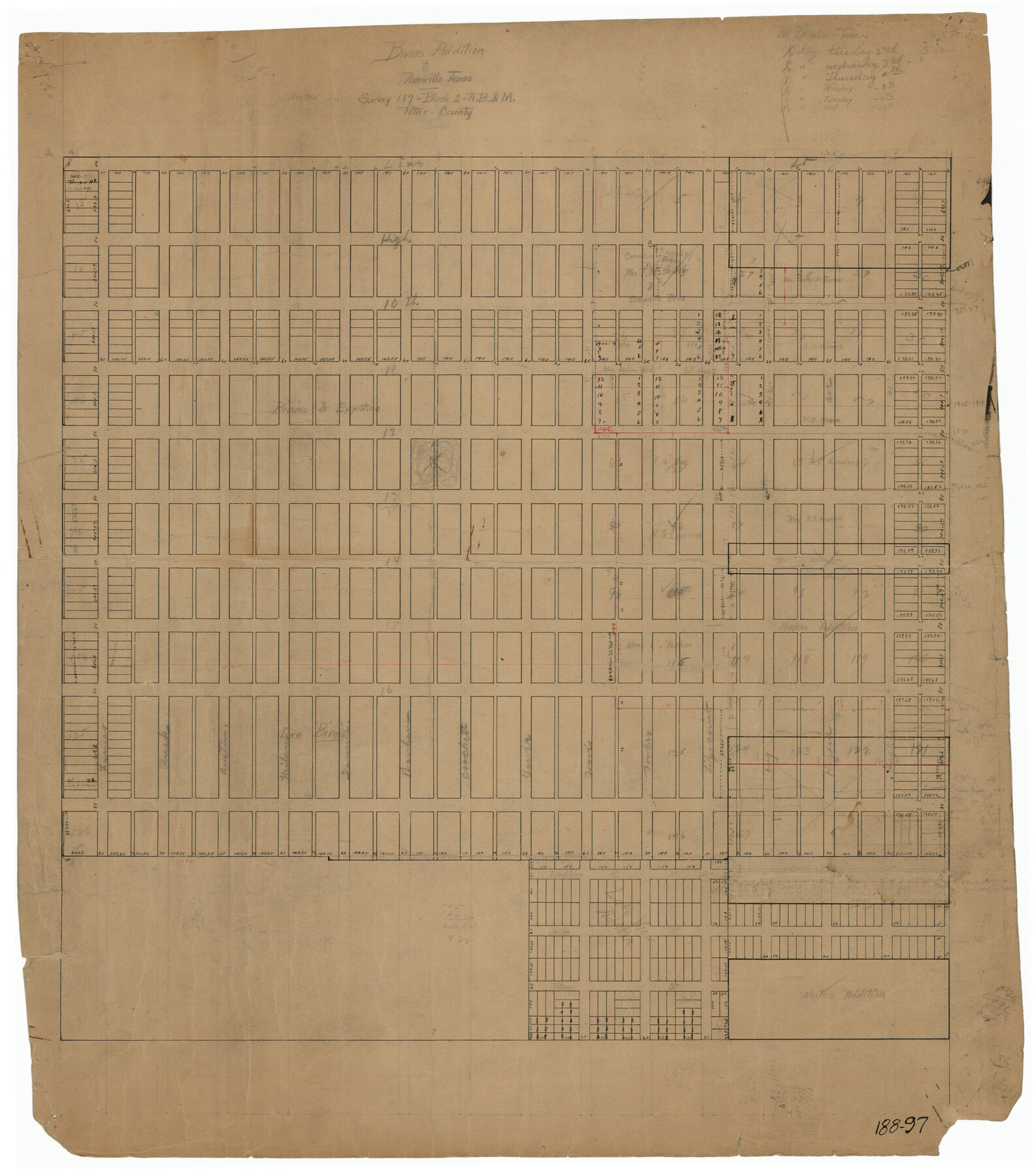
Bivin's Addition to Amarillo, Texas, Survey 187, Block 2, A. B. & M., Potter County
188-97
-
Map/Doc
91739
-
Collection
Twichell Survey Records
-
Counties
Potter
-
Height x Width
20.1 x 23.0 inches
51.1 x 58.4 cm
Part of: Twichell Survey Records
[Surveys to the North and West of the Francis Blundell survey containing townsite]
![90884, [Surveys to the North and West of the Francis Blundell survey containing townsite], Twichell Survey Records](https://historictexasmaps.com/wmedia_w700/maps/90884-1.tif.jpg)
Print $20.00
- Digital $50.00
[Surveys to the North and West of the Francis Blundell survey containing townsite]
Size 26.3 x 19.8 inches
Map/Doc 90884
Whitehead Addition, City of Lubbock

Print $20.00
- Digital $50.00
Whitehead Addition, City of Lubbock
Size 17.9 x 24.6 inches
Map/Doc 92779
Working Sketch in Bastrop County

Print $20.00
- Digital $50.00
Working Sketch in Bastrop County
1921
Size 14.0 x 15.8 inches
Map/Doc 90232
[East Neches River]
![90420, [East Neches River], Twichell Survey Records](https://historictexasmaps.com/wmedia_w700/maps/90420-1.tif.jpg)
Print $20.00
- Digital $50.00
[East Neches River]
Size 25.8 x 29.3 inches
Map/Doc 90420
[Sketch Number 1, Block LC2 and Adjacent Leagues]
![91476, [Sketch Number 1, Block LC2 and Adjacent Leagues], Twichell Survey Records](https://historictexasmaps.com/wmedia_w700/maps/91476-1.tif.jpg)
Print $20.00
- Digital $50.00
[Sketch Number 1, Block LC2 and Adjacent Leagues]
Size 25.6 x 40.8 inches
Map/Doc 91476
[Blk. B, Secs. 111-114 and vicinity]
![90340, [Blk. B, Secs. 111-114 and vicinity], Twichell Survey Records](https://historictexasmaps.com/wmedia_w700/maps/90340-1.tif.jpg)
Print $20.00
- Digital $50.00
[Blk. B, Secs. 111-114 and vicinity]
Size 31.3 x 38.7 inches
Map/Doc 90340
J. B. McCauley Farm Section 17, Block AK

Print $20.00
- Digital $50.00
J. B. McCauley Farm Section 17, Block AK
Size 22.9 x 27.3 inches
Map/Doc 92297
[John W. Carpenter and Surrounding Surveys]
![91085, [John W. Carpenter and Surrounding Surveys], Twichell Survey Records](https://historictexasmaps.com/wmedia_w700/maps/91085-1.tif.jpg)
Print $20.00
- Digital $50.00
[John W. Carpenter and Surrounding Surveys]
1922
Size 17.7 x 29.6 inches
Map/Doc 91085
Property Line Map, Low Rent Housing Project Texas 18-1, Housing Authority of the City of Lubbock

Print $20.00
- Digital $50.00
Property Line Map, Low Rent Housing Project Texas 18-1, Housing Authority of the City of Lubbock
1941
Size 42.2 x 27.9 inches
Map/Doc 92753
Progressive Military Map of the United States, Southern Department, Sheet 403N, Comstock

Print $20.00
- Digital $50.00
Progressive Military Map of the United States, Southern Department, Sheet 403N, Comstock
1916
Size 35.0 x 23.9 inches
Map/Doc 92062

[T. & P. RR. Co. Blocks 54, 55 and 76, Townships 1 and 2]
![89888, [T. & P. RR. Co. Blocks 54, 55 and 76, Townships 1 and 2], Twichell Survey Records](https://historictexasmaps.com/wmedia_w700/maps/89888-1.tif.jpg)
Print $20.00
- Digital $50.00
[T. & P. RR. Co. Blocks 54, 55 and 76, Townships 1 and 2]
Size 44.2 x 36.2 inches
Map/Doc 89888
You may also like
Parmer County Working Sketch 1

Print $20.00
- Digital $50.00
Parmer County Working Sketch 1
1903
Map/Doc 71469

Harris County NRC Article 33.136 Sketch 17

Print $26.00
- Digital $50.00
Harris County NRC Article 33.136 Sketch 17
2011
Size 22.0 x 17.0 inches
Map/Doc 94758
Webb County Rolled Sketch 46

Print $20.00
- Digital $50.00
Webb County Rolled Sketch 46
1942
Size 25.8 x 27.6 inches
Map/Doc 8202
Nueces County Sketch File 13

Print $20.00
- Digital $50.00
Nueces County Sketch File 13
1940
Size 18.3 x 18.7 inches
Map/Doc 42178
Exeter and Wilson Empresario Colony. September 23, 1828

Print $20.00
Exeter and Wilson Empresario Colony. September 23, 1828
2020
Size 15.5 x 21.7 inches
Map/Doc 95994
Duval County Sketch File 4b

Print $4.00
- Digital $50.00
Duval County Sketch File 4b
1874
Size 10.4 x 7.8 inches
Map/Doc 21282
The Republic County of Fayette. May 3, 1838

Print $20.00
The Republic County of Fayette. May 3, 1838
2020
Size 14.7 x 21.7 inches
Map/Doc 96132
Hopkins County Sketch File 17

Print $6.00
- Digital $50.00
Hopkins County Sketch File 17
1870
Size 7.8 x 8.0 inches
Map/Doc 26720
Edwards County Sketch File 14

Print $24.00
- Digital $50.00
Edwards County Sketch File 14
1891
Size 12.9 x 8.7 inches
Map/Doc 21703
McMullen County Working Sketch 4

Print $20.00
- Digital $50.00
McMullen County Working Sketch 4
1922
Size 36.2 x 36.6 inches
Map/Doc 70705
Travis County Sketch File 6

Print $8.00
- Digital $50.00
Travis County Sketch File 6
1841
Size 13.8 x 10.9 inches
Map/Doc 38283