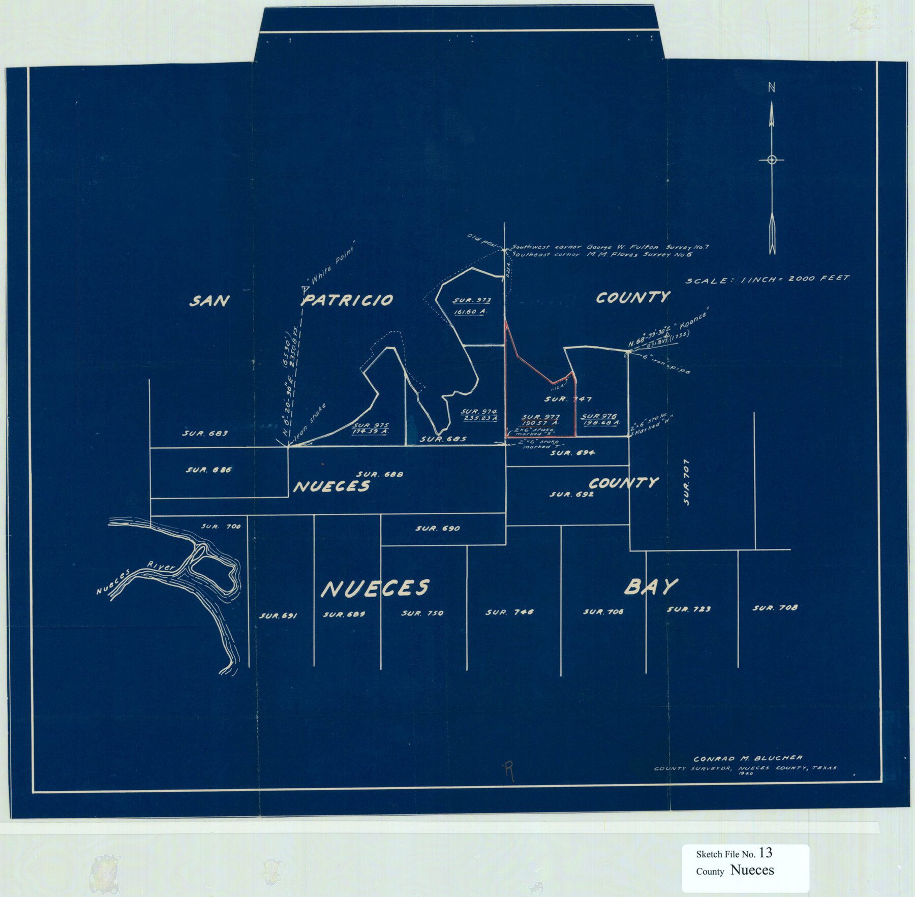
Nueces County Sketch File 13
[Sketch of Nueces Bay]
-
Map/Doc
42178
-
Collection
General Map Collection
-
Object Dates
1940 (Survey Date)
1940 (Creation Date)
-
People and Organizations
Conrad M. Blucher (Surveyor/Engineer)
-
Counties
Nueces
-
Subjects
Surveying Sketch File
-
Height x Width
18.3 x 18.7 inches
46.5 x 47.5 cm
-
Medium
blueprint/diazo
-
Scale
1" = 2000'
-
Features
Nueces River
Part of: General Map Collection
Flight Mission No. DIX-6P, Frame 121, Aransas County

Print $20.00
- Digital $50.00
Flight Mission No. DIX-6P, Frame 121, Aransas County
1956
Size 18.9 x 22.6 inches
Map/Doc 83827
Titus County Working Sketch 3

Print $20.00
- Digital $50.00
Titus County Working Sketch 3
Size 21.7 x 31.8 inches
Map/Doc 69364
Irion County Rolled Sketch 21

Print $40.00
- Digital $50.00
Irion County Rolled Sketch 21
Size 52.8 x 44.0 inches
Map/Doc 9256
Bandera County Working Sketch 12

Print $20.00
- Digital $50.00
Bandera County Working Sketch 12
Size 34.0 x 36.9 inches
Map/Doc 67605
Flight Mission No. CRC-3R, Frame 103, Chambers County

Print $20.00
- Digital $50.00
Flight Mission No. CRC-3R, Frame 103, Chambers County
1956
Size 18.7 x 22.4 inches
Map/Doc 84841
Flight Mission No. CLL-3N, Frame 4, Willacy County

Print $20.00
- Digital $50.00
Flight Mission No. CLL-3N, Frame 4, Willacy County
1954
Size 18.5 x 22.0 inches
Map/Doc 87070
Johnson County Working Sketch 9

Print $20.00
- Digital $50.00
Johnson County Working Sketch 9
1953
Size 20.4 x 15.2 inches
Map/Doc 66622

Aransas County Working Sketch 20

Print $20.00
- Digital $50.00
Aransas County Working Sketch 20
1980
Size 11.9 x 24.4 inches
Map/Doc 67187
Polk County Working Sketch 23b

Print $40.00
- Digital $50.00
Polk County Working Sketch 23b
1957
Size 28.8 x 54.6 inches
Map/Doc 71639
Polk County Rolled Sketch 30

Print $20.00
- Digital $50.00
Polk County Rolled Sketch 30
1958
Size 27.8 x 31.5 inches
Map/Doc 7316
Webb County Rolled Sketch 35

Print $20.00
- Digital $50.00
Webb County Rolled Sketch 35
1939
Size 23.1 x 12.7 inches
Map/Doc 8190
You may also like
United States Mileage Chart / United States Mileage Table / Hawaii / Alaska

United States Mileage Chart / United States Mileage Table / Hawaii / Alaska
Size 26.5 x 38.1 inches
Map/Doc 96820
Flight Mission No. CUG-2P, Frame 23, Kleberg County

Print $20.00
- Digital $50.00
Flight Mission No. CUG-2P, Frame 23, Kleberg County
1956
Size 18.6 x 22.3 inches
Map/Doc 86187
Flight Mission No. DQO-7K, Frame 106, Galveston County

Print $20.00
- Digital $50.00
Flight Mission No. DQO-7K, Frame 106, Galveston County
1952
Size 18.5 x 22.6 inches
Map/Doc 85121
Brewster County Sketch File N-20

Print $40.00
- Digital $50.00
Brewster County Sketch File N-20
1941
Size 16.5 x 20.5 inches
Map/Doc 10967
Travis County Sketch File 37

Print $4.00
- Digital $50.00
Travis County Sketch File 37
Size 8.2 x 10.1 inches
Map/Doc 38357
Hardin County Rolled Sketch 20

Print $20.00
- Digital $50.00
Hardin County Rolled Sketch 20
1960
Size 27.7 x 35.9 inches
Map/Doc 6089
Frio County Sketch File 2a

Print $6.00
- Digital $50.00
Frio County Sketch File 2a
1861
Size 16.0 x 11.0 inches
Map/Doc 23107
Supreme Court of the United States, October Term, 1923, No. 15, Original - The State of Oklahoma, Complainant vs. The State of Texas, Defendant, The United States, Intervener; Report of the Boundary Commissioners

Print $20.00
- Digital $50.00
Supreme Court of the United States, October Term, 1923, No. 15, Original - The State of Oklahoma, Complainant vs. The State of Texas, Defendant, The United States, Intervener; Report of the Boundary Commissioners
1923
Size 34.4 x 40.6 inches
Map/Doc 75120
Cottle County Sketch File 2

Print $20.00
- Digital $50.00
Cottle County Sketch File 2
1882
Size 32.9 x 19.6 inches
Map/Doc 76757
Flight Mission No. BRA-7M, Frame 80, Jefferson County

Print $20.00
- Digital $50.00
Flight Mission No. BRA-7M, Frame 80, Jefferson County
1953
Size 15.9 x 15.8 inches
Map/Doc 85502
Stonewall County Sketch File 5

Print $40.00
- Digital $50.00
Stonewall County Sketch File 5
Size 14.9 x 14.4 inches
Map/Doc 37206
Cooke County Sketch File 41

Print $36.00
- Digital $50.00
Cooke County Sketch File 41
1928
Size 11.3 x 8.9 inches
Map/Doc 19308