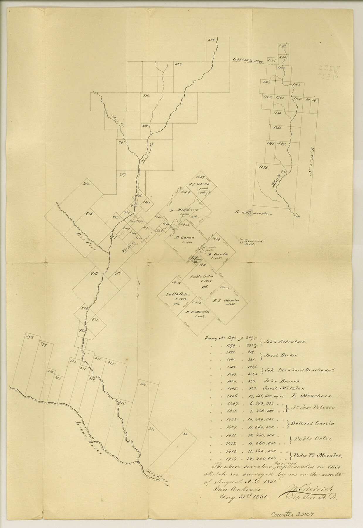
Frio County Sketch File 2a
[Sketch of surveys on Leona and Rio Frio]
-
Map/Doc
23107
-
Collection
General Map Collection
-
Object Dates
1861/10/23 (File Date)
1861 (Survey Date)
1861/8/31 (Creation Date)
-
People and Organizations
W. Friedrich (Surveyor/Engineer)
-
Counties
Frio
-
Subjects
Surveying Sketch File
-
Height x Width
16.0 x 11.0 inches
40.6 x 27.9 cm
-
Medium
paper, manuscript
-
Features
Seco Creek
Black Creek
Hondo Creek
Rio Frio
Round Mountain
Liveoak Hill
Turkey Creek
Huisache Lake
Leona River
Part of: General Map Collection
[Cotton Belt, St. Louis Southwestern Railway of Texas, Alignment through Smith County]
![64384, [Cotton Belt, St. Louis Southwestern Railway of Texas, Alignment through Smith County], General Map Collection](https://historictexasmaps.com/wmedia_w700/maps/64384.tif.jpg)
Print $20.00
- Digital $50.00
[Cotton Belt, St. Louis Southwestern Railway of Texas, Alignment through Smith County]
1903
Size 21.4 x 29.9 inches
Map/Doc 64384
Hemphill County Sketch File 6a

Print $10.00
- Digital $50.00
Hemphill County Sketch File 6a
1903
Size 9.2 x 6.1 inches
Map/Doc 26303
Flight Mission No. CRE-1R, Frame 194, Jackson County

Print $20.00
- Digital $50.00
Flight Mission No. CRE-1R, Frame 194, Jackson County
1956
Size 18.5 x 22.3 inches
Map/Doc 85348
Houston County Working Sketch 14

Print $20.00
- Digital $50.00
Houston County Working Sketch 14
1957
Size 35.1 x 24.0 inches
Map/Doc 66244
Schleicher County Sketch File 15

Print $22.00
- Digital $50.00
Schleicher County Sketch File 15
1928
Size 8.1 x 12.9 inches
Map/Doc 36504
Menard County Sketch File 29

Print $20.00
- Digital $50.00
Menard County Sketch File 29
1962
Size 21.0 x 41.1 inches
Map/Doc 10543
Outer Continental Shelf Leasing Maps (Texas Offshore Operations)

Print $20.00
- Digital $50.00
Outer Continental Shelf Leasing Maps (Texas Offshore Operations)
1954
Size 14.6 x 15.6 inches
Map/Doc 75836
Travis County Sketch File 71

Print $10.00
- Digital $50.00
Travis County Sketch File 71
1840
Size 12.9 x 8.3 inches
Map/Doc 38456
Uvalde County Rolled Sketch 14

Print $20.00
- Digital $50.00
Uvalde County Rolled Sketch 14
1977
Size 22.0 x 25.9 inches
Map/Doc 8098
Ward County Working Sketch 6

Print $20.00
- Digital $50.00
Ward County Working Sketch 6
1945
Size 23.4 x 24.5 inches
Map/Doc 72312
A Plat of 23 Miles of the Colorado River
![65651, [Sketch for Mineral Application 1742], General Map Collection](https://historictexasmaps.com/wmedia_w700/maps/65651.tif.jpg)
Print $40.00
- Digital $50.00
A Plat of 23 Miles of the Colorado River
1918
Size 38.3 x 56.7 inches
Map/Doc 65651
Terrell County Working Sketch 5

Print $20.00
- Digital $50.00
Terrell County Working Sketch 5
1914
Size 32.0 x 26.3 inches
Map/Doc 62154
You may also like
Buenaventura Reyes Grants

Print $20.00
- Digital $50.00
Buenaventura Reyes Grants
1896
Size 14.9 x 13.5 inches
Map/Doc 2057
Flight Mission No. BRE-1P, Frame 139, Nueces County

Print $20.00
- Digital $50.00
Flight Mission No. BRE-1P, Frame 139, Nueces County
1956
Size 18.8 x 22.6 inches
Map/Doc 86699
International boundary between the United States and Mexico in the Rio Grande and Colorado River delineated in accordance with the Treaty of November 23, 1970 - Volume 1

International boundary between the United States and Mexico in the Rio Grande and Colorado River delineated in accordance with the Treaty of November 23, 1970 - Volume 1
1972
Map/Doc 1747

Clarkson's City Map of Port Aransas

Print $20.00
- Digital $50.00
Clarkson's City Map of Port Aransas
Size 18.5 x 26.7 inches
Map/Doc 3038
Culberson County Working Sketch 63

Print $20.00
- Digital $50.00
Culberson County Working Sketch 63
1975
Size 34.1 x 24.9 inches
Map/Doc 68517
Map of the United States of America, the British Provinces, Mexico, the West Indies and Central America with part of New Granada and Venezuela

Print $20.00
- Digital $50.00
Map of the United States of America, the British Provinces, Mexico, the West Indies and Central America with part of New Granada and Venezuela
1855
Size 34.7 x 44.0 inches
Map/Doc 93904
Kinney County Sketch File 35

Print $6.00
- Digital $50.00
Kinney County Sketch File 35
1944
Size 14.2 x 8.7 inches
Map/Doc 29185
Real County Sketch File 3

Print $16.00
- Digital $50.00
Real County Sketch File 3
1906
Size 9.2 x 8.2 inches
Map/Doc 35039
Flight Mission No. DAG-21K, Frame 96, Matagorda County

Print $20.00
- Digital $50.00
Flight Mission No. DAG-21K, Frame 96, Matagorda County
1952
Size 18.4 x 22.4 inches
Map/Doc 86425
Frio County Working Sketch 17

Print $20.00
- Digital $50.00
Frio County Working Sketch 17
1980
Size 14.4 x 16.8 inches
Map/Doc 69291
