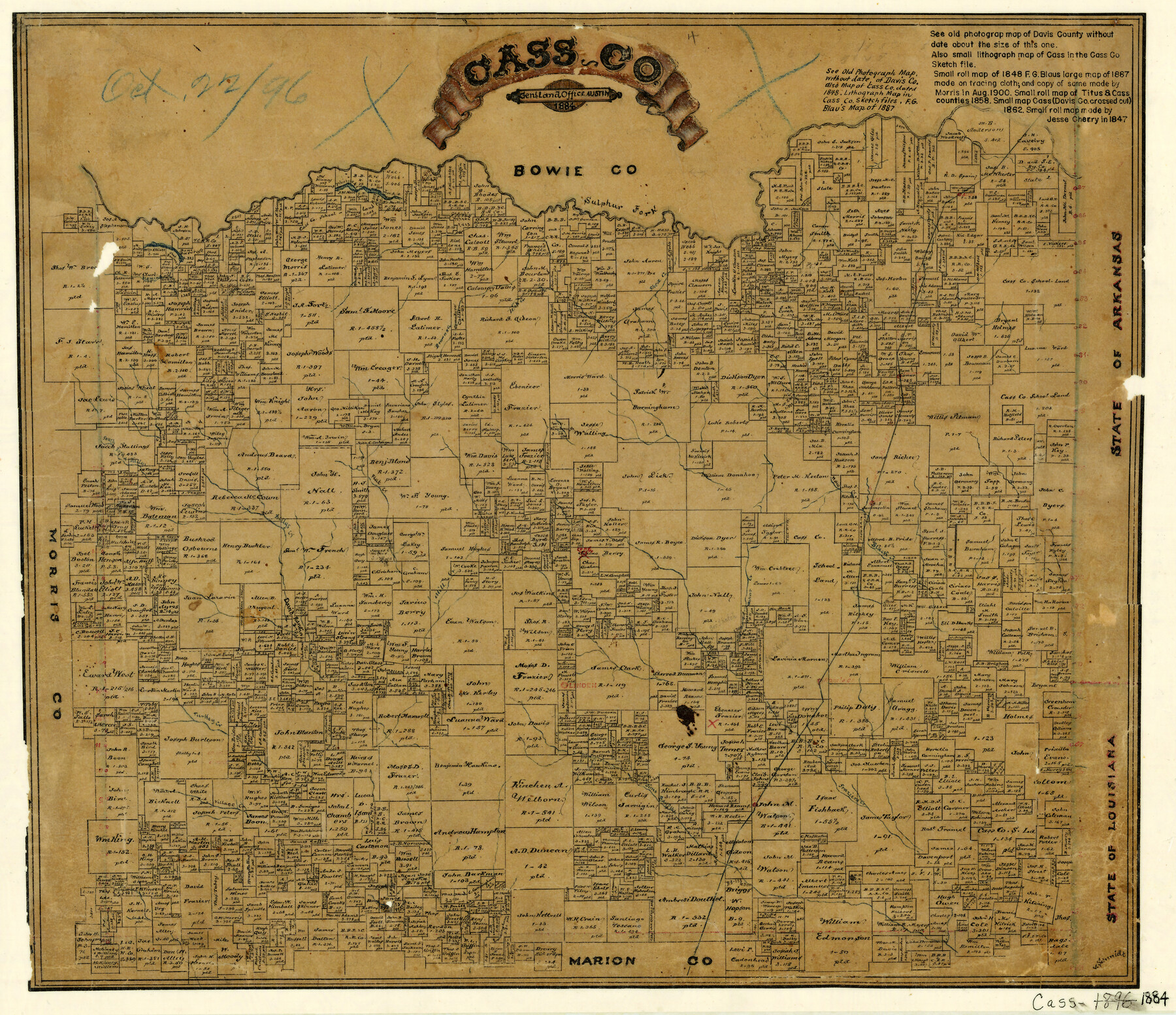
Cass County
-
Map/Doc
3374
-
Collection
General Map Collection
-
Object Dates
1884 (Creation Date)
-
People and Organizations
V. Schmidt (Draftsman)
-
Counties
Cass
-
Subjects
County
-
Height x Width
17.3 x 20.2 inches
43.9 x 51.3 cm
-
Features
Mill Creek
T&P
Kildare
Atlaillo
Hoxies
Lanark
Village Creek
Turkey Creek
Jims Bayou
Fraziers Creek
Linden
Kellys Creek
Sulphur Fork [of Red River]
Johns Creek
Black Creek
Marita
Haw Creek
Flat Creek
South Fork of Kelly's Creek
Browns Creek
Shea Creek
Lick Creek
Fleming Creek
Thomas Lake
Part of: General Map Collection
Motley County Sketch File 32 (S)

Print $4.00
- Digital $50.00
Motley County Sketch File 32 (S)
Size 11.3 x 8.7 inches
Map/Doc 32215
Flight Mission No. BRA-16M, Frame 97, Jefferson County

Print $20.00
- Digital $50.00
Flight Mission No. BRA-16M, Frame 97, Jefferson County
1953
Size 18.5 x 22.4 inches
Map/Doc 85709
Bandera County Working Sketch 32

Print $20.00
- Digital $50.00
Bandera County Working Sketch 32
1956
Size 22.7 x 18.4 inches
Map/Doc 67628
Kinney County Sketch File 16

Print $20.00
- Digital $50.00
Kinney County Sketch File 16
1887
Size 23.2 x 25.4 inches
Map/Doc 11941
Map of Cameron County

Print $40.00
- Digital $50.00
Map of Cameron County
1895
Size 48.9 x 28.9 inches
Map/Doc 4901
Hood County Sketch File 27

Print $4.00
- Digital $50.00
Hood County Sketch File 27
1873
Size 12.9 x 8.5 inches
Map/Doc 26629
Comal County Sketch File 20

Print $6.00
- Digital $50.00
Comal County Sketch File 20
1857
Size 12.4 x 8.1 inches
Map/Doc 19039
Zapata County Sketch File 13

Print $4.00
- Digital $50.00
Zapata County Sketch File 13
1930
Size 11.3 x 8.8 inches
Map/Doc 40952
A Topographical Map of the Government Tract adjoining the City of Austin

Print $20.00
- Digital $50.00
A Topographical Map of the Government Tract adjoining the City of Austin
1840
Size 41.9 x 37.8 inches
Map/Doc 2180
Hardeman County Sketch File 15

Print $20.00
- Digital $50.00
Hardeman County Sketch File 15
Size 18.9 x 17.9 inches
Map/Doc 11627

Titus County Working Sketch 2

Print $20.00
- Digital $50.00
Titus County Working Sketch 2
Size 23.6 x 25.3 inches
Map/Doc 69363
You may also like
Van Zandt County Working Sketch 15

Print $20.00
- Digital $50.00
Van Zandt County Working Sketch 15
1982
Size 30.9 x 39.0 inches
Map/Doc 72265
Wise County Sketch File 32

Print $5.00
- Digital $50.00
Wise County Sketch File 32
1880
Size 16.4 x 11.0 inches
Map/Doc 40588
Live Oak County Working Sketch 33

Print $20.00
- Digital $50.00
Live Oak County Working Sketch 33
1992
Size 25.9 x 35.1 inches
Map/Doc 70618
Current Miscellaneous File 74

Print $14.00
- Digital $50.00
Current Miscellaneous File 74
1850
Size 11.2 x 8.7 inches
Map/Doc 74181
Runnels County Sketch File 15

Print $42.00
Runnels County Sketch File 15
1883
Size 9.2 x 7.9 inches
Map/Doc 35459
[Neches River Bed, Plat and Calculations]
![77100, [Neches River Bed, Plat and Calculations], General Map Collection](https://historictexasmaps.com/wmedia_w700/maps/77100.tif.jpg)
Print $20.00
- Digital $50.00
[Neches River Bed, Plat and Calculations]
1928
Size 25.6 x 37.2 inches
Map/Doc 77100
D No. 5 - Reconnaissance of Hatteras Inlet, North Carolina

Print $20.00
- Digital $50.00
D No. 5 - Reconnaissance of Hatteras Inlet, North Carolina
1853
Size 17.1 x 14.9 inches
Map/Doc 97212
Gray County Sketch File 13

Print $20.00
- Digital $50.00
Gray County Sketch File 13
1946
Size 16.7 x 15.9 inches
Map/Doc 11578
Leon County Working Sketch 52b

Print $20.00
- Digital $50.00
Leon County Working Sketch 52b
1982
Size 33.6 x 33.5 inches
Map/Doc 70452
General Highway Map, Atascosa County, Texas

Print $20.00
General Highway Map, Atascosa County, Texas
1961
Size 18.3 x 24.9 inches
Map/Doc 79356
Pecos County Working Sketch 24

Print $20.00
- Digital $50.00
Pecos County Working Sketch 24
1928
Size 26.9 x 33.0 inches
Map/Doc 71495
Colorado County Sketch File 9

Print $3.00
- Digital $50.00
Colorado County Sketch File 9
Size 11.3 x 17.0 inches
Map/Doc 11134