Gray County Sketch File 13
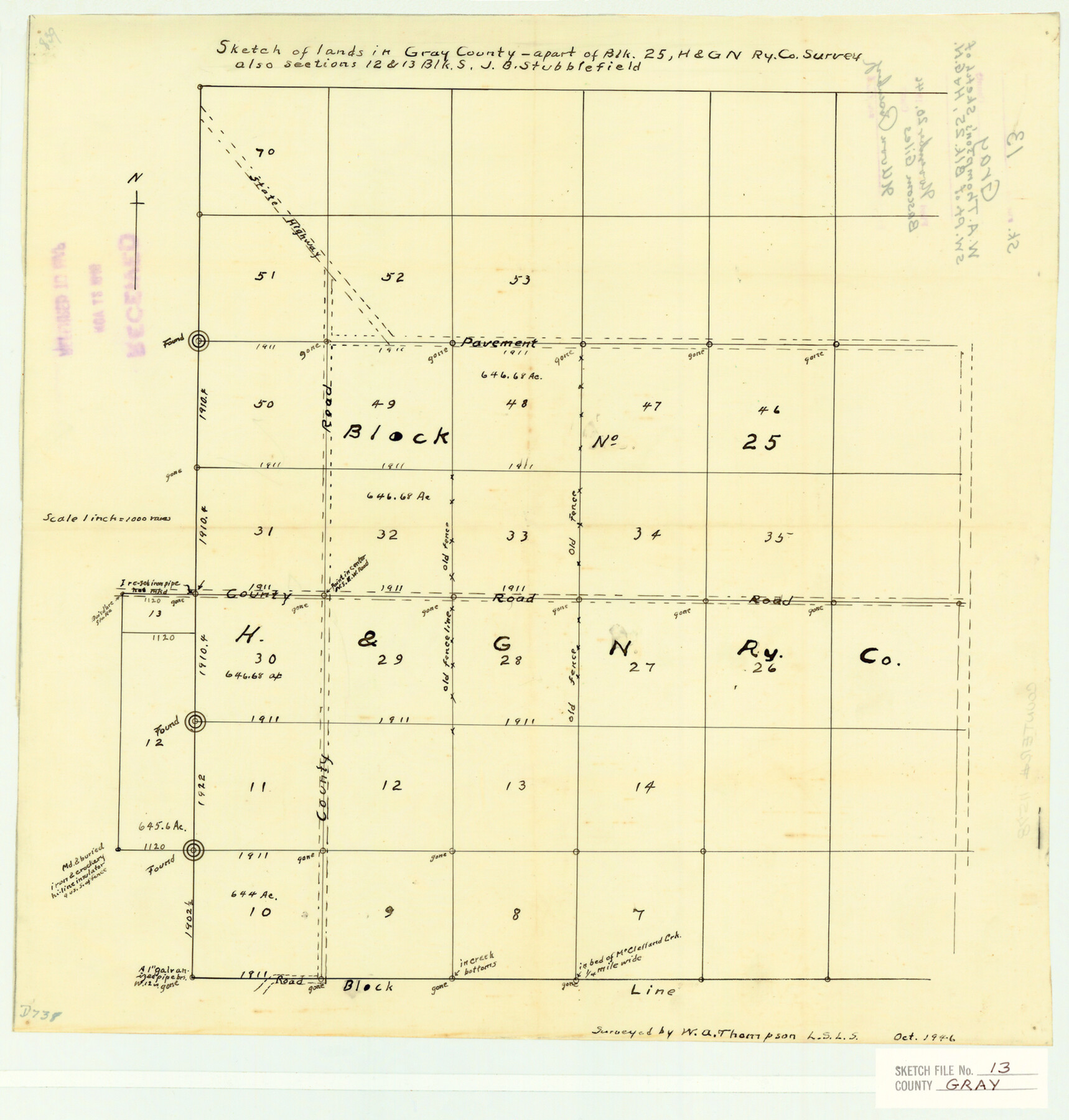
Sketch of Lands in Gray County - a part of Blk. 25, H&GN Ry. Co. Survey also Sections 12 & 13 Blk. S, J. B. Stubblefield
-
Map/Doc
11578
-
Collection
General Map Collection
-
Object Dates
1946 (Creation Date)
1946/11/20 (File Date)
1946 (Survey Date)
-
People and Organizations
W.A. Thompson (Surveyor/Engineer)
-
Counties
Gray
-
Subjects
Surveying Sketch File
-
Height x Width
16.7 x 15.9 inches
42.4 x 40.4 cm
-
Medium
paper, manuscript
-
Scale
1" = 1000 varas
-
Features
County Road
Part of: General Map Collection
Fort Bend County Sketch File 33

Print $20.00
- Digital $50.00
Fort Bend County Sketch File 33
1889
Size 23.6 x 24.5 inches
Map/Doc 11513
Bee County Working Sketch 25

Print $20.00
- Digital $50.00
Bee County Working Sketch 25
1987
Size 38.8 x 26.0 inches
Map/Doc 67275
Texas, Matagorda Bay, Vicinity of Trespalacios Bay

Print $40.00
- Digital $50.00
Texas, Matagorda Bay, Vicinity of Trespalacios Bay
1933
Size 49.0 x 32.6 inches
Map/Doc 69988
Sutton County Working Sketch 31

Print $20.00
- Digital $50.00
Sutton County Working Sketch 31
1929
Size 19.2 x 21.8 inches
Map/Doc 62374
Hale County Sketch File 16

Print $4.00
- Digital $50.00
Hale County Sketch File 16
1888
Size 12.8 x 8.2 inches
Map/Doc 24747
Louisiana and Texas Intracoastal Waterway - Sabine River-Galveston Bay Section, Steel Sheet Pile Dyke at Galveston Bay Entrance

Print $20.00
- Digital $50.00
Louisiana and Texas Intracoastal Waterway - Sabine River-Galveston Bay Section, Steel Sheet Pile Dyke at Galveston Bay Entrance
1933
Size 31.4 x 40.9 inches
Map/Doc 61818
Atascosa County Sketch File 30

Print $18.00
- Digital $50.00
Atascosa County Sketch File 30
1900
Size 11.2 x 8.8 inches
Map/Doc 13816
Wilson County Sketch File 4

Print $28.00
- Digital $50.00
Wilson County Sketch File 4
1851
Size 8.4 x 7.7 inches
Map/Doc 40404
McMullen County Working Sketch 6

Print $20.00
- Digital $50.00
McMullen County Working Sketch 6
1926
Size 24.5 x 22.9 inches
Map/Doc 70707
Palo Pinto County Sketch File 25

Print $26.00
- Digital $50.00
Palo Pinto County Sketch File 25
1874
Size 10.1 x 8.9 inches
Map/Doc 33404
Kerr County Sketch File 9

Print $8.00
- Digital $50.00
Kerr County Sketch File 9
1884
Size 10.2 x 8.2 inches
Map/Doc 28873
Stonewall County Working Sketch 12

Print $20.00
- Digital $50.00
Stonewall County Working Sketch 12
1950
Size 27.9 x 27.9 inches
Map/Doc 62319
You may also like
Flight Mission No. DAH-9M, Frame 199, Orange County

Print $20.00
- Digital $50.00
Flight Mission No. DAH-9M, Frame 199, Orange County
1953
Size 18.6 x 22.5 inches
Map/Doc 86867
Map of Galveston, Harrisburg & San Antonio Railway in Pecos County

Print $40.00
- Digital $50.00
Map of Galveston, Harrisburg & San Antonio Railway in Pecos County
1888
Size 26.0 x 80.9 inches
Map/Doc 64399
Brewster County Rolled Sketch 134

Print $20.00
- Digital $50.00
Brewster County Rolled Sketch 134
Size 19.0 x 24.9 inches
Map/Doc 5303
Matagorda Light to Aransas Pass

Print $20.00
- Digital $50.00
Matagorda Light to Aransas Pass
1924
Size 35.9 x 44.6 inches
Map/Doc 73391
Flight Mission No. DAG-26K, Frame 61, Matagorda County

Print $20.00
- Digital $50.00
Flight Mission No. DAG-26K, Frame 61, Matagorda County
1953
Size 18.7 x 22.6 inches
Map/Doc 86581
Burnet County Sketch File 40

Print $4.00
- Digital $50.00
Burnet County Sketch File 40
Size 14.2 x 8.6 inches
Map/Doc 16755
Atascosa County Rolled Sketch 5A

Print $20.00
- Digital $50.00
Atascosa County Rolled Sketch 5A
1910
Size 20.8 x 14.4 inches
Map/Doc 5089
Maps of Gulf Intracoastal Waterway, Texas - Sabine River to the Rio Grande and connecting waterways including ship channels

Print $20.00
- Digital $50.00
Maps of Gulf Intracoastal Waterway, Texas - Sabine River to the Rio Grande and connecting waterways including ship channels
1966
Size 14.4 x 22.2 inches
Map/Doc 61943
Travis County Sketch File 22

Print $6.00
- Digital $50.00
Travis County Sketch File 22
1875
Size 8.5 x 8.5 inches
Map/Doc 38327
Brewster County Rolled Sketch A

Print $40.00
- Digital $50.00
Brewster County Rolled Sketch A
Size 26.7 x 94.8 inches
Map/Doc 8925
Matagorda County NRC Article 33.136 Sketch 5

Print $28.00
- Digital $50.00
Matagorda County NRC Article 33.136 Sketch 5
2009
Size 24.2 x 35.0 inches
Map/Doc 95006
Brazoria County NRC Article 33.136 Sketch 28

Print $24.00
Brazoria County NRC Article 33.136 Sketch 28
2025
Map/Doc 97473