Atascosa County Sketch File 30
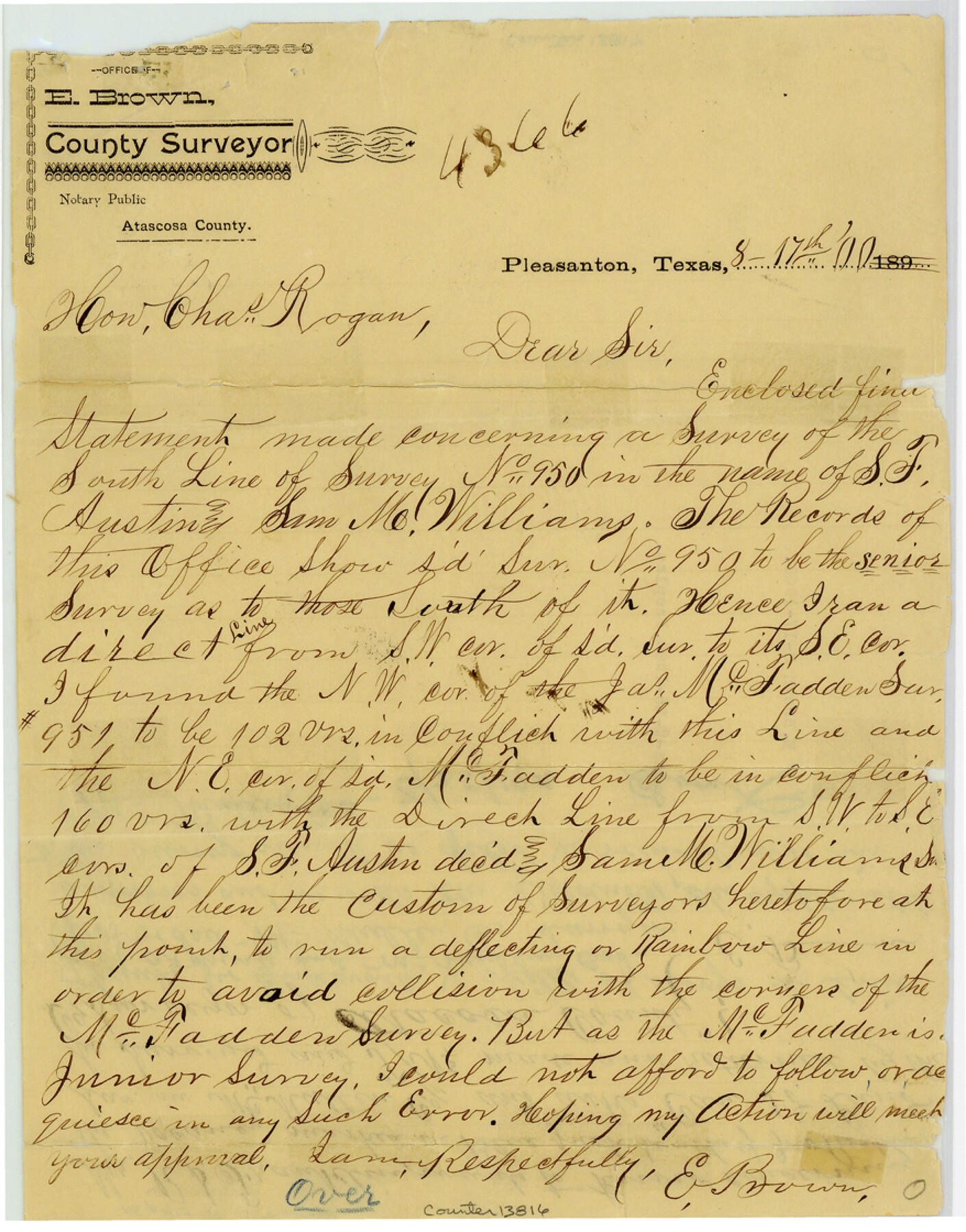
[Statement of survey relating to the establishment of the south line of survey 950]
-
Map/Doc
13816
-
Collection
General Map Collection
-
Object Dates
1900/8/17 (Creation Date)
1900/8/24 (File Date)
-
People and Organizations
E. Brown (Surveyor/Engineer)
J.L. Heime (Chainman)
Marrah Franklin (Chainman)
-
Counties
Atascosa
-
Subjects
Surveying Sketch File
-
Height x Width
11.2 x 8.8 inches
28.4 x 22.4 cm
-
Medium
multi-page, multi-format
-
Features
San Miguel Creek
Part of: General Map Collection
Brazos River, Jones Bridge Special Map Sheet

Print $4.00
- Digital $50.00
Brazos River, Jones Bridge Special Map Sheet
1936
Size 29.8 x 28.2 inches
Map/Doc 65280
Navigation Maps of Gulf Intracoastal Waterway, Port Arthur to Brownsville, Texas

Print $4.00
- Digital $50.00
Navigation Maps of Gulf Intracoastal Waterway, Port Arthur to Brownsville, Texas
1951
Size 16.7 x 21.5 inches
Map/Doc 65421
Runnels County Sketch File 29

Print $20.00
Runnels County Sketch File 29
1950
Size 23.8 x 18.0 inches
Map/Doc 12261
Right of Way and Track Map, The Wichita Falls & Southern Railway

Print $40.00
- Digital $50.00
Right of Way and Track Map, The Wichita Falls & Southern Railway
1942
Size 25.0 x 121.0 inches
Map/Doc 64512
Bailey County Sketch File B

Print $40.00
- Digital $50.00
Bailey County Sketch File B
Size 14.5 x 20.4 inches
Map/Doc 10891
Concho County Sketch File 46

Print $24.00
- Digital $50.00
Concho County Sketch File 46
1961
Size 14.2 x 8.6 inches
Map/Doc 19213
Topography of the Colorado River in the City of Austin

Print $4.00
- Digital $50.00
Topography of the Colorado River in the City of Austin
1941
Size 18.7 x 29.6 inches
Map/Doc 65326
Crane County Rolled Sketch 7

Print $20.00
- Digital $50.00
Crane County Rolled Sketch 7
1927
Size 33.4 x 44.8 inches
Map/Doc 8679
Pecos County Sketch File 67

Print $76.00
- Digital $50.00
Pecos County Sketch File 67
1919
Size 14.1 x 8.8 inches
Map/Doc 33828
Flight Mission No. CRC-3R, Frame 203, Chambers County

Print $20.00
- Digital $50.00
Flight Mission No. CRC-3R, Frame 203, Chambers County
1956
Size 18.6 x 22.3 inches
Map/Doc 84858
San Antonio & Aransas Pass

Print $40.00
- Digital $50.00
San Antonio & Aransas Pass
Size 30.9 x 74.5 inches
Map/Doc 64633
San Patricio County Rolled Sketch 27B

Print $40.00
- Digital $50.00
San Patricio County Rolled Sketch 27B
Size 50.3 x 38.4 inches
Map/Doc 9892
You may also like
Montague County Sketch File 14

Print $4.00
- Digital $50.00
Montague County Sketch File 14
1880
Size 7.8 x 5.4 inches
Map/Doc 31740
General Highway Map, Fannin County, Texas

Print $20.00
General Highway Map, Fannin County, Texas
1961
Size 24.7 x 18.0 inches
Map/Doc 79464
Map of the Middle States designed to accompany Smith's Geography for Schools

Print $20.00
- Digital $50.00
Map of the Middle States designed to accompany Smith's Geography for Schools
1850
Size 19.4 x 12.2 inches
Map/Doc 93887
Blanco County Sketch File 2

Print $5.00
- Digital $50.00
Blanco County Sketch File 2
Size 10.3 x 8.5 inches
Map/Doc 14580
Coryell County Sketch File 9

Print $4.00
- Digital $50.00
Coryell County Sketch File 9
1858
Size 7.2 x 8.2 inches
Map/Doc 19359
Reeves County Sketch File 20

Print $8.00
- Digital $50.00
Reeves County Sketch File 20
1943
Size 9.9 x 8.5 inches
Map/Doc 35216
Hudspeth County Sketch File 53

Print $6.00
- Digital $50.00
Hudspeth County Sketch File 53
1993
Size 14.3 x 8.9 inches
Map/Doc 27076
Hays County Sketch File 31

Print $6.00
- Digital $50.00
Hays County Sketch File 31
1943
Size 14.4 x 8.8 inches
Map/Doc 26261


Gregg County Rolled Sketch 26

Print $40.00
- Digital $50.00
Gregg County Rolled Sketch 26
1937
Size 25.8 x 129.0 inches
Map/Doc 9077