Hays County Sketch File 31
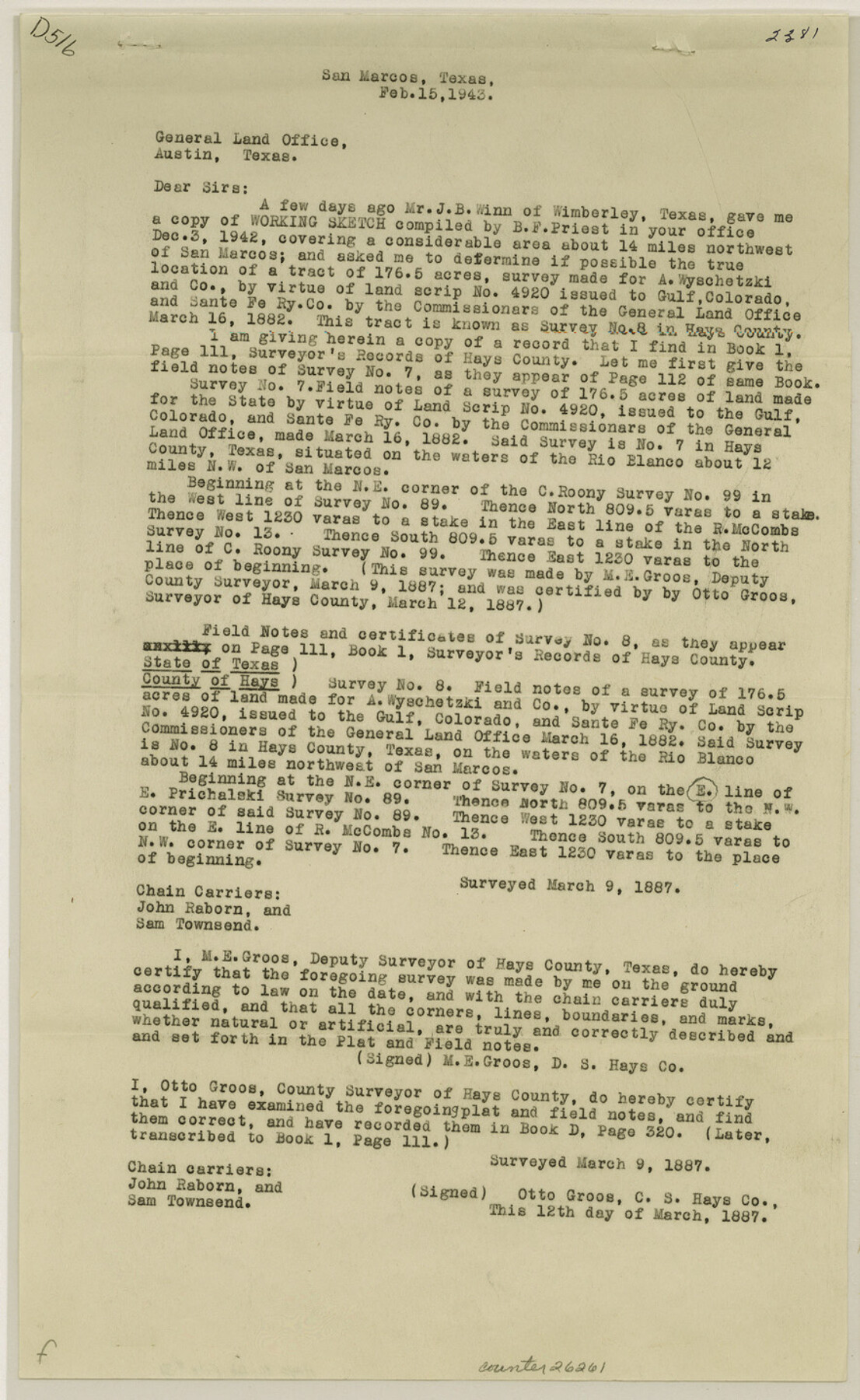
[Report by S. M. Sewell regarding correct location of survey 8, G. C. & S. F. RR. Co.]
-
Map/Doc
26261
-
Collection
General Map Collection
-
Object Dates
2/15/1943 (Creation Date)
2/16/1943 (File Date)
2/15/1943 (Correspondence Date)
3/9/1887 (Survey Date)
-
People and Organizations
S.M. Sewell (Surveyor/Engineer)
B.F. Priest (Draftsman)
Otto Groos (Surveyor/Engineer)
John Raborn (Chainman)
Sam Townsend (Chainman)
-
Counties
Hays
-
Subjects
Surveying Sketch File
-
Height x Width
14.4 x 8.8 inches
36.6 x 22.4 cm
-
Medium
paper, print
-
Features
Rio Blanco
Part of: General Map Collection
County of Galveston, Texas

Print $20.00
- Digital $50.00
County of Galveston, Texas
1845
Size 22.9 x 32.2 inches
Map/Doc 3574
Flight Mission No. DQN-1K, Frame 120, Calhoun County

Print $20.00
- Digital $50.00
Flight Mission No. DQN-1K, Frame 120, Calhoun County
1953
Size 18.5 x 22.2 inches
Map/Doc 84186
Pecos County Working Sketch Graphic index - northwest part - sheet A

Print $20.00
- Digital $50.00
Pecos County Working Sketch Graphic index - northwest part - sheet A
1975
Size 42.2 x 42.6 inches
Map/Doc 76663
Navigation Maps of Gulf Intracoastal Waterway, Port Arthur to Brownsville, Texas

Print $4.00
- Digital $50.00
Navigation Maps of Gulf Intracoastal Waterway, Port Arthur to Brownsville, Texas
1951
Size 16.6 x 21.6 inches
Map/Doc 65432
Denton County Working Sketch 17

Print $20.00
- Digital $50.00
Denton County Working Sketch 17
1973
Size 31.6 x 33.6 inches
Map/Doc 68622
Armstrong County Working Sketch 1

Print $20.00
- Digital $50.00
Armstrong County Working Sketch 1
1903
Size 10.3 x 17.2 inches
Map/Doc 67232
Matagorda Light to Aransas Pass

Print $20.00
- Digital $50.00
Matagorda Light to Aransas Pass
1972
Size 35.9 x 44.8 inches
Map/Doc 73400
Real County Working Sketch 20

Print $20.00
- Digital $50.00
Real County Working Sketch 20
1944
Size 19.0 x 24.9 inches
Map/Doc 71912
Baylor County Sketch File 24

Print $6.00
- Digital $50.00
Baylor County Sketch File 24
1934
Size 13.9 x 8.8 inches
Map/Doc 14209
West Part of Liberty Co.

Print $40.00
- Digital $50.00
West Part of Liberty Co.
1977
Size 48.0 x 36.9 inches
Map/Doc 95570
Brewster County Rolled Sketch 115

Print $40.00
- Digital $50.00
Brewster County Rolled Sketch 115
1958
Size 11.5 x 138.4 inches
Map/Doc 8514
Jefferson County Rolled Sketch 52

Print $40.00
- Digital $50.00
Jefferson County Rolled Sketch 52
Size 28.2 x 52.9 inches
Map/Doc 9308
You may also like

J No. 5 - Reconnaissance of San Pedro Harbor, California

Print $20.00
- Digital $50.00
J No. 5 - Reconnaissance of San Pedro Harbor, California
1852
Size 12.3 x 15.5 inches
Map/Doc 97232
Flight Mission No. DQN-1K, Frame 133, Calhoun County

Print $20.00
- Digital $50.00
Flight Mission No. DQN-1K, Frame 133, Calhoun County
1953
Size 18.6 x 22.4 inches
Map/Doc 84196
Palo Pinto County Sketch File 29

Print $40.00
- Digital $50.00
Palo Pinto County Sketch File 29
1874
Size 12.8 x 16.0 inches
Map/Doc 33419
Maps & Lists Showing Prison Lands (Oil & Gas) Leased as of June 1955

Digital $50.00
Maps & Lists Showing Prison Lands (Oil & Gas) Leased as of June 1955
Size 11.2 x 8.9 inches
Map/Doc 62875

El Paso County Working Sketch 17

Print $20.00
- Digital $50.00
El Paso County Working Sketch 17
1958
Size 28.4 x 26.3 inches
Map/Doc 69039
DeWitt County Working Sketch 2b

Print $20.00
- Digital $50.00
DeWitt County Working Sketch 2b
1940
Size 25.1 x 30.0 inches
Map/Doc 68647

Map of Bexar County Oil Fields

Print $40.00
Map of Bexar County Oil Fields
1919
Size 37.6 x 49.0 inches
Map/Doc 79307
Edwards County Working Sketch Graphic Index - east part - sheet 1

Print $40.00
- Digital $50.00
Edwards County Working Sketch Graphic Index - east part - sheet 1
1975
Size 54.8 x 39.9 inches
Map/Doc 76533
[Surveys in Polk County]
![329, [Surveys in Polk County], General Map Collection](https://historictexasmaps.com/wmedia_w700/maps/329.tif.jpg)
Print $2.00
- Digital $50.00
[Surveys in Polk County]
1847
Size 6.6 x 8.0 inches
Map/Doc 329