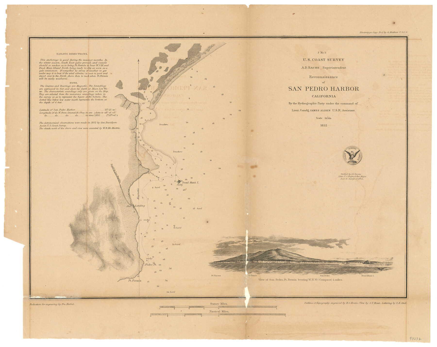
J No. 5 - Reconnaissance of San Pedro Harbor, California
-
Map/Doc
97232
-
Collection
General Map Collection
-
Object Dates
1852 (Creation Date)
-
People and Organizations
A.D. Bache (Superintendent)
James Alden (Surveyor/Engineer)
I.I. Stevens (Surveyor/Engineer)
U.S. Coast Survey (Publisher)
-
Subjects
Coastal
-
Height x Width
12.3 x 15.5 inches
31.2 x 39.4 cm
-
Comments
Sketch from the book "Report of the Superintendent of the Coast Survey Showing the Progress of the Survey in the year 1852" (81738)
Related maps
Report of the Superintendent of the Coast Survey showing the progress of the survey during the year 1852

Report of the Superintendent of the Coast Survey showing the progress of the survey during the year 1852
1853
Map/Doc 81738
Part of: General Map Collection
Hemphill County Rolled Sketch 18

Print $20.00
- Digital $50.00
Hemphill County Rolled Sketch 18
Size 23.6 x 35.0 inches
Map/Doc 6200
Flight Mission No. DAH-17M, Frame 24, Orange County

Print $20.00
- Digital $50.00
Flight Mission No. DAH-17M, Frame 24, Orange County
1953
Size 18.5 x 22.4 inches
Map/Doc 86887
Flight Mission No. DCL-6C, Frame 115, Kenedy County

Print $20.00
- Digital $50.00
Flight Mission No. DCL-6C, Frame 115, Kenedy County
1943
Size 18.5 x 22.4 inches
Map/Doc 85945
McCulloch County Working Sketch 12

Print $20.00
- Digital $50.00
McCulloch County Working Sketch 12
1982
Size 37.5 x 20.1 inches
Map/Doc 70687
Gaines County Rolled Sketch 24

Print $20.00
- Digital $50.00
Gaines County Rolled Sketch 24
1965
Size 41.8 x 31.3 inches
Map/Doc 9314
Ochiltree County Boundary File 1b

Print $16.00
- Digital $50.00
Ochiltree County Boundary File 1b
Size 8.6 x 8.4 inches
Map/Doc 57666
Crane County Working Sketch 31

Print $20.00
- Digital $50.00
Crane County Working Sketch 31
1982
Size 34.3 x 37.7 inches
Map/Doc 68308
Lampasas County Working Sketch 2

Print $20.00
- Digital $50.00
Lampasas County Working Sketch 2
1936
Size 14.4 x 18.0 inches
Map/Doc 70279
Lee County Working Sketch 8

Print $20.00
- Digital $50.00
Lee County Working Sketch 8
1979
Size 27.8 x 37.1 inches
Map/Doc 70387
[Surveys near the Neches River]
![8, [Surveys near the Neches River], General Map Collection](https://historictexasmaps.com/wmedia_w700/maps/8.tif.jpg)
Print $3.00
- Digital $50.00
[Surveys near the Neches River]
Size 17.2 x 10.3 inches
Map/Doc 8
Ector County Working Sketch Graphic Index - sheet A

Print $20.00
- Digital $50.00
Ector County Working Sketch Graphic Index - sheet A
1943
Size 44.5 x 39.1 inches
Map/Doc 76530
Navarro County Working Sketch Graphic Index

Print $40.00
- Digital $50.00
Navarro County Working Sketch Graphic Index
1924
Size 42.7 x 48.7 inches
Map/Doc 76652
You may also like
Nueces County Rolled Sketch M-9

Print $20.00
- Digital $50.00
Nueces County Rolled Sketch M-9
1913
Size 37.6 x 38.3 inches
Map/Doc 9588
Houston County Working Sketch 7

Print $20.00
- Digital $50.00
Houston County Working Sketch 7
1935
Size 24.7 x 36.8 inches
Map/Doc 66237
Tyler County Working Sketch 6

Print $20.00
- Digital $50.00
Tyler County Working Sketch 6
1934
Size 24.3 x 36.5 inches
Map/Doc 69476
Connected Map of Austin's Colony

Print $40.00
- Digital $50.00
Connected Map of Austin's Colony
1837
Size 90.6 x 80.9 inches
Map/Doc 1943
Milam County Boundary File 2

Print $30.00
- Digital $50.00
Milam County Boundary File 2
Size 12.7 x 8.2 inches
Map/Doc 57202
Throckmorton County Sketch File 11

Print $30.00
- Digital $50.00
Throckmorton County Sketch File 11
1884
Size 8.9 x 11.6 inches
Map/Doc 38105
Entrance to Sabine Pass, Texas from survey of May and June 1892 under the direction of Major James B. Quinn, Corps of Engineers, USA

Print $20.00
- Digital $50.00
Entrance to Sabine Pass, Texas from survey of May and June 1892 under the direction of Major James B. Quinn, Corps of Engineers, USA
1892
Size 18.8 x 32.9 inches
Map/Doc 94154
Bosque County Sketch File 18

Print $4.00
- Digital $50.00
Bosque County Sketch File 18
1863
Size 13.5 x 8.4 inches
Map/Doc 14792
Shelby County

Print $40.00
- Digital $50.00
Shelby County
1897
Size 43.4 x 50.1 inches
Map/Doc 63033

Flight Mission No. DQN-3K, Frame 8, Calhoun County

Print $20.00
- Digital $50.00
Flight Mission No. DQN-3K, Frame 8, Calhoun County
1953
Size 18.5 x 22.1 inches
Map/Doc 84340
Live Oak County Working Sketch 33

Print $20.00
- Digital $50.00
Live Oak County Working Sketch 33
1992
Size 25.9 x 35.1 inches
Map/Doc 70618