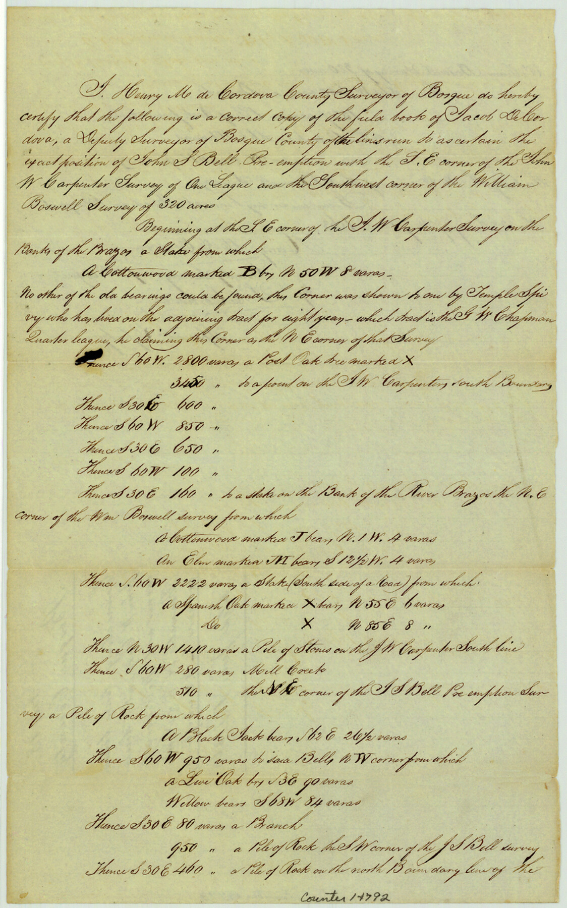
Bosque County Sketch File 18
[Field notes of connecting lines between John W. Carpenter lower corner and William Boswell northeast and northwest corners]
- 
                          Map/Doc14792
- 
                            CollectionGeneral Map Collection
- 
                            Object Dates1863/5/28 (Creation Date)1863/6/1 (File Date)
- 
                            People and OrganizationsHenry M. De Cordova (Surveyor/Engineer)J. De Cordova (Surveyor/Engineer)
- 
                            CountiesBosque
- 
                            SubjectsSurveying Sketch File
- 
                            Height x Width13.5 x 8.4 inches34.3 x 21.3 cm
- 
                            Mediumpaper, manuscript
- 
                            FeaturesBrazos RiverMill Creek
Part of: General Map Collection
            DeWitt County Working Sketch 9


                                            Print $20.00                    
                                             -                         Digital $50.00                                    
                DeWitt County Working Sketch 9
1979
Size 15.7 x 23.4 inches
                                Map/Doc 68599
            
            Borden County Boundary File 6


                                            Print $28.00                    
                                             -                         Digital $50.00                                    
                Borden County Boundary File 6
1908
Size 11.3 x 25.1 inches
                                Map/Doc 1717
            
            Coast Chart No. 212 - From Latitude 26° 33' to the Rio Grande Texas


                                            Print $20.00                    
                                             -                         Digital $50.00                                    
                Coast Chart No. 212 - From Latitude 26° 33' to the Rio Grande Texas
1886
Size 27.2 x 18.2 inches
                                Map/Doc 72830
            
            Kent County Sketch File 8


                                            Print $20.00                    
                                             -                         Digital $50.00                                    
                Kent County Sketch File 8
Size 19.0 x 40.8 inches
                                Map/Doc 10515
            
            Little River, Cameron Sheet


                                            Print $4.00                    
                                             -                         Digital $50.00                                    
                Little River, Cameron Sheet
1914
Size 28.3 x 24.4 inches
                                Map/Doc 65062
            
            Central United States [Recto]
            
                                    ![94194, Central United States [Recto], General Map Collection](https://historictexasmaps.com/wmedia_w700/maps/94194.tif.jpg) 


    ![94194, Central United States [Recto], General Map Collection](https://historictexasmaps.com/wmedia_w700/maps/94194.tif.jpg) 
                                
            Central United States [Recto]
1958
Size 18.3 x 38.6 inches
                                Map/Doc 94194
            
            Harrison County Working Sketch 13


                                            Print $20.00                    
                                             -                         Digital $50.00                                    
                Harrison County Working Sketch 13
1961
Size 32.4 x 37.0 inches
                                Map/Doc 66033
            
            Washington County


                                            Print $20.00                    
                                             -                         Digital $50.00                                    
                Washington County
1920
Size 32.5 x 47.2 inches
                                Map/Doc 16918
            
            [Sketch for Mineral Application 19443 - Brazos River]
            
                                    ![65683, [Sketch for Mineral Application 19443 - Brazos River], General Map Collection](https://historictexasmaps.com/wmedia_w700/maps/65683.tif.jpg) 


    ![65683, [Sketch for Mineral Application 19443 - Brazos River], General Map Collection](https://historictexasmaps.com/wmedia_w700/maps/65683.tif.jpg) 
                                
            
                                            Print $40.00                    
                                             -                         Digital $50.00                                    
                [Sketch for Mineral Application 19443 - Brazos River]
1853
Size 117.1 x 30.5 inches
                                Map/Doc 65683
            
            Atascosa County Sketch File 2b


                                            Print $6.00                    
                                             -                         Digital $50.00                                    
                Atascosa County Sketch File 2b
1855
Size 8.8 x 13.2 inches
                                Map/Doc 13728
            
            Clay County Boundary File 15


                                            Print $8.00                    
                                             -                         Digital $50.00                                    
                Clay County Boundary File 15
Size 13.3 x 8.2 inches
                                Map/Doc 51418
            
            Dickens County Sketch File 9


                                            Print $4.00                    
                                             -                         Digital $50.00                                    
                Dickens County Sketch File 9
Size 21.6 x 20.9 inches
                                Map/Doc 11319
            You may also like
            Jefferson County Working Sketch 28


                                            Print $20.00                    
                                             -                         Digital $50.00                                    
                Jefferson County Working Sketch 28
1977
Size 46.2 x 42.9 inches
                                Map/Doc 66571
            
            Ward County Working Sketch 33


                                            Print $20.00                    
                                             -                         Digital $50.00                                    
                Ward County Working Sketch 33
1968
Size 26.3 x 32.3 inches
                                Map/Doc 72339
            
            Freestone County Working Sketch 25


                                            Print $20.00                    
                                             -                         Digital $50.00                                    
                Freestone County Working Sketch 25
1984
Size 43.5 x 38.4 inches
                                Map/Doc 69267
            
            Reagan County Working Sketch 26


                                            Print $20.00                    
                                             -                         Digital $50.00                                    
                Reagan County Working Sketch 26
1960
Size 29.4 x 41.0 inches
                                Map/Doc 71868
            
            Texas in 1840, or the Emigrant's Guide to the New Republic; being the result of observation, enquiry and travel in that beautiful country


            Texas in 1840, or the Emigrant's Guide to the New Republic; being the result of observation, enquiry and travel in that beautiful country
1840
Map/Doc 97198
            
            Childress County Rolled Sketch 16A


                                            Print $20.00                    
                                             -                         Digital $50.00                                    
                Childress County Rolled Sketch 16A
Size 44.3 x 36.9 inches
                                Map/Doc 8599
            
            Red River County Working Sketch 21


                                            Print $6.00                    
                                             -                         Digital $50.00                                    
                Red River County Working Sketch 21
1955
Size 33.2 x 18.5 inches
                                Map/Doc 72004
            
            Jefferson County Working Sketch 11


                                            Print $20.00                    
                                             -                         Digital $50.00                                    
                Jefferson County Working Sketch 11
1943
Size 46.6 x 43.0 inches
                                Map/Doc 66554
            
            Hemphill County Working Sketch 13


                                            Print $20.00                    
                                             -                         Digital $50.00                                    
                Hemphill County Working Sketch 13
1968
Size 26.2 x 24.0 inches
                                Map/Doc 66108
            
            Flight Mission No. BRA-6M, Frame 91, Jefferson County


                                            Print $20.00                    
                                             -                         Digital $50.00                                    
                Flight Mission No. BRA-6M, Frame 91, Jefferson County
1953
Size 18.5 x 22.4 inches
                                Map/Doc 85434
            
            [Office Sketch of County School Land surveys in Schleicher County, Texas]
            
                                    ![75770, [Office Sketch of County School Land surveys in Schleicher County, Texas], Maddox Collection](https://historictexasmaps.com/wmedia_w700/maps/75770.tif.jpg) 


    ![75770, [Office Sketch of County School Land surveys in Schleicher County, Texas], Maddox Collection](https://historictexasmaps.com/wmedia_w700/maps/75770.tif.jpg) 
                                
            
                                            Print $20.00                    
                                             -                         Digital $50.00                                    
                [Office Sketch of County School Land surveys in Schleicher County, Texas]
Size 13.1 x 21.0 inches
                                Map/Doc 75770
             
                            