Report of the Superintendent of the Coast Survey showing the progress of the survey during the year 1852

Report of the Superintendent of the Coast Survey showing the progress of the survey during the year 1852
1853
81738
Souvenir of Galveston the Sea Wall City

Souvenir of Galveston the Sea Wall City
Size: 5.7 x 7.6 inches
97051
The Texas Coast Country and What It Holds for You

The Texas Coast Country and What It Holds for You
1909
Size: 6.4 x 3.7 inches
97054
Greater Texas and the Coast Country - The Winter Garden

Greater Texas and the Coast Country - The Winter Garden
1911
Size: 9.4 x 4.5 inches
97057

Texas Coast Country on the Southern Pacific Lines

Texas Coast Country on the Southern Pacific Lines
1917
Size: 9.4 x 6.4 inches
97061

Sketch I: Showing the Progress of the Survey in Section No. 9 [Galveston Bay]
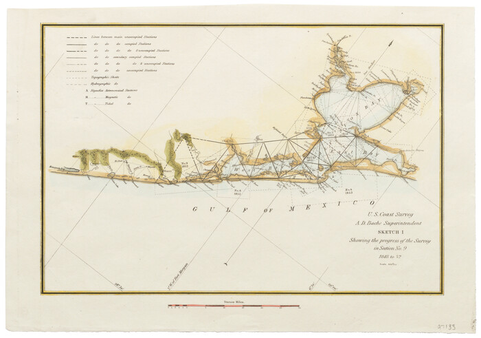
Print $20.00
- Digital $50.00
Sketch I: Showing the Progress of the Survey in Section No. 9 [Galveston Bay]
1852
Size: 9.4 x 13.4 inches
97133
Port Series No. 6 - The Ports of Galveston, Houston, and Texas City, Texas

Port Series No. 6 - The Ports of Galveston, Houston, and Texas City, Texas
1924
97159
Port Facilities at Texas City, Tex.

Print $20.00
- Digital $50.00
Port Facilities at Texas City, Tex.
1924
Size: 13.9 x 15.9 inches
97161
Vicinity map showing railroads serving the ports of Galveston, Houston and Texas City, Texas

Print $20.00
- Digital $50.00
Vicinity map showing railroads serving the ports of Galveston, Houston and Texas City, Texas
1924
Size: 9.3 x 14.8 inches
97164
Port Facilities at Houston, Tex.

Print $20.00
- Digital $50.00
Port Facilities at Houston, Tex.
1924
Size: 14.1 x 30.3 inches
97167
Brazos Santiago, Texas

Print $20.00
- Digital $50.00
Brazos Santiago, Texas
1882
Size: 9.0 x 16.9 inches
97186
Sketch A Shewing the progress of the Survey in Section No. 1 From 1844 to 1852

Print $20.00
- Digital $50.00
Sketch A Shewing the progress of the Survey in Section No. 1 From 1844 to 1852
1852
Size: 38.1 x 25.3 inches
97200
Sketch C Showing the Progress of the Survey in Section III From 1843 to 1852

Print $20.00
- Digital $50.00
Sketch C Showing the Progress of the Survey in Section III From 1843 to 1852
1852
Size: 36.2 x 25.6 inches
97201
Sketch A Shewing the progress of the Survey in Section No. 1 From 1844 to 1851

Print $20.00
- Digital $50.00
Sketch A Shewing the progress of the Survey in Section No. 1 From 1844 to 1851
1851
Size: 37.1 x 24.5 inches
97202
(A No. 2) Preliminary Sketch Showing the positions of Davis's South Shoal and other Dangers recently discovered by the Coast Survey and the soundings on the Old South Shoal, Bass Rip, Old Man, Pochick Rip &c.

Print $20.00
- Digital $50.00
(A No. 2) Preliminary Sketch Showing the positions of Davis's South Shoal and other Dangers recently discovered by the Coast Survey and the soundings on the Old South Shoal, Bass Rip, Old Man, Pochick Rip &c.
1846
Size: 19.7 x 21.8 inches
97203
Sketch B Showing the progress of Section No. 2

Print $20.00
- Digital $50.00
Sketch B Showing the progress of Section No. 2
1844
Size: 25.3 x 27.7 inches
97204
Sketch C Showing the Progress of the Survey in Section III From 1843 to 1851

Print $20.00
- Digital $50.00
Sketch C Showing the Progress of the Survey in Section III From 1843 to 1851
1851
Size: 35.7 x 23.0 inches
97205
C No. 2 - Preliminary Sketch of Chincoteague Inlet and Shoals in the Vicinity - Sea Coast of Virginia

Print $20.00
- Digital $50.00
C No. 2 - Preliminary Sketch of Chincoteague Inlet and Shoals in the Vicinity - Sea Coast of Virginia
1852
Size: 16.5 x 19.4 inches
97206
C No. 3 - Sea Coast of Delaware, Maryland, and part of Virginia

Print $20.00
- Digital $50.00
C No. 3 - Sea Coast of Delaware, Maryland, and part of Virginia
1852
Size: 30.4 x 22.2 inches
97207
Sketch D Showing the progress of Section IV 1845 to 1852

Print $20.00
- Digital $50.00
Sketch D Showing the progress of Section IV 1845 to 1852
1852
Size: 22.8 x 13.0 inches
97208
Sketch D No. 2 Showing the Progress of the Survey of Cape Fear and Vicinity in Sections No. IV & V

Digital $50.00
Sketch D No. 2 Showing the Progress of the Survey of Cape Fear and Vicinity in Sections No. IV & V
1852
Size: 12.3 x 10.0 inches
97209
D No. 3 - Sketch of Ocracoke Inlet, North Carolina

Print $20.00
- Digital $50.00
D No. 3 - Sketch of Ocracoke Inlet, North Carolina
1852
Size: 17.0 x 16.1 inches
97210
D No. 4 - Reconnaissance of New River and Bar, North Carolina

Print $20.00
- Digital $50.00
D No. 4 - Reconnaissance of New River and Bar, North Carolina
1852
Size: 19.4 x 15.7 inches
97211
D No. 5 - Reconnaissance of Hatteras Inlet, North Carolina

Print $20.00
- Digital $50.00
D No. 5 - Reconnaissance of Hatteras Inlet, North Carolina
1853
Size: 17.1 x 14.9 inches
97212
Report of the Superintendent of the Coast Survey showing the progress of the survey during the year 1852
Report of the Superintendent of the Coast Survey showing the progress of the survey during the year 1852
1853
-
Map/Doc
81738
-
Creation Date
1853
Souvenir of Galveston

Souvenir of Galveston
1896
-
Size
5.3 x 7.2 inches
-
Map/Doc
97049
-
Creation Date
1896
Souvenir of Galveston the Sea Wall City
Souvenir of Galveston the Sea Wall City
-
Size
5.7 x 7.6 inches
-
Map/Doc
97051
The Gulf Coast of Texas

The Gulf Coast of Texas
1906
-
Size
9.5 x 5.3 inches
-
Map/Doc
97053
-
Creation Date
1906
The Texas Coast Country and What It Holds for You
The Texas Coast Country and What It Holds for You
1909
-
Size
6.4 x 3.7 inches
-
Map/Doc
97054
-
Creation Date
1909
Greater Texas and the Coast Country - The Winter Garden
Greater Texas and the Coast Country - The Winter Garden
1911
-
Size
9.4 x 4.5 inches
-
Map/Doc
97057
-
Creation Date
1911
Texas Coast Country on the Southern Pacific Lines
Texas Coast Country on the Southern Pacific Lines
1917
-
Size
9.4 x 6.4 inches
-
Map/Doc
97061
-
Creation Date
1917
The Texas Gulf Coast

The Texas Gulf Coast
1940
-
Size
9.4 x 4.2 inches
-
Map/Doc
97066
-
Creation Date
1940
Sketch I: Showing the Progress of the Survey in Section No. 9 [Galveston Bay]
Print $20.00
- Digital $50.00
Sketch I: Showing the Progress of the Survey in Section No. 9 [Galveston Bay]
1852
-
Size
9.4 x 13.4 inches
-
Map/Doc
97133
-
Creation Date
1852
Port Series No. 6 - The Ports of Galveston, Houston, and Texas City, Texas
Port Series No. 6 - The Ports of Galveston, Houston, and Texas City, Texas
1924
-
Map/Doc
97159
-
Creation Date
1924
Port Facilities at Texas City, Tex.
Print $20.00
- Digital $50.00
Port Facilities at Texas City, Tex.
1924
-
Size
13.9 x 15.9 inches
-
Map/Doc
97161
-
Creation Date
1924
Vicinity map showing railroads serving the ports of Galveston, Houston and Texas City, Texas
Print $20.00
- Digital $50.00
Vicinity map showing railroads serving the ports of Galveston, Houston and Texas City, Texas
1924
-
Size
9.3 x 14.8 inches
-
Map/Doc
97164
-
Creation Date
1924
Port Facilities at Houston, Tex.
Print $20.00
- Digital $50.00
Port Facilities at Houston, Tex.
1924
-
Size
14.1 x 30.3 inches
-
Map/Doc
97167
-
Creation Date
1924
Brazos Santiago, Texas
Print $20.00
- Digital $50.00
Brazos Santiago, Texas
1882
-
Size
9.0 x 16.9 inches
-
Map/Doc
97186
-
Creation Date
1882
Padre Island, Texas

Padre Island, Texas
1968
-
Size
29.8 x 19.5 inches
-
Map/Doc
97196
-
Creation Date
1968
Sketch A Shewing the progress of the Survey in Section No. 1 From 1844 to 1852
Print $20.00
- Digital $50.00
Sketch A Shewing the progress of the Survey in Section No. 1 From 1844 to 1852
1852
-
Size
38.1 x 25.3 inches
-
Map/Doc
97200
-
Creation Date
1852
Sketch C Showing the Progress of the Survey in Section III From 1843 to 1852
Print $20.00
- Digital $50.00
Sketch C Showing the Progress of the Survey in Section III From 1843 to 1852
1852
-
Size
36.2 x 25.6 inches
-
Map/Doc
97201
-
Creation Date
1852
Sketch A Shewing the progress of the Survey in Section No. 1 From 1844 to 1851
Print $20.00
- Digital $50.00
Sketch A Shewing the progress of the Survey in Section No. 1 From 1844 to 1851
1851
-
Size
37.1 x 24.5 inches
-
Map/Doc
97202
-
Creation Date
1851
(A No. 2) Preliminary Sketch Showing the positions of Davis's South Shoal and other Dangers recently discovered by the Coast Survey and the soundings on the Old South Shoal, Bass Rip, Old Man, Pochick Rip &c.
Print $20.00
- Digital $50.00
(A No. 2) Preliminary Sketch Showing the positions of Davis's South Shoal and other Dangers recently discovered by the Coast Survey and the soundings on the Old South Shoal, Bass Rip, Old Man, Pochick Rip &c.
1846
-
Size
19.7 x 21.8 inches
-
Map/Doc
97203
-
Creation Date
1846
Sketch B Showing the progress of Section No. 2
Print $20.00
- Digital $50.00
Sketch B Showing the progress of Section No. 2
1844
-
Size
25.3 x 27.7 inches
-
Map/Doc
97204
-
Creation Date
1844
Sketch C Showing the Progress of the Survey in Section III From 1843 to 1851
Print $20.00
- Digital $50.00
Sketch C Showing the Progress of the Survey in Section III From 1843 to 1851
1851
-
Size
35.7 x 23.0 inches
-
Map/Doc
97205
-
Creation Date
1851
C No. 2 - Preliminary Sketch of Chincoteague Inlet and Shoals in the Vicinity - Sea Coast of Virginia
Print $20.00
- Digital $50.00
C No. 2 - Preliminary Sketch of Chincoteague Inlet and Shoals in the Vicinity - Sea Coast of Virginia
1852
-
Size
16.5 x 19.4 inches
-
Map/Doc
97206
-
Creation Date
1852
C No. 3 - Sea Coast of Delaware, Maryland, and part of Virginia
Print $20.00
- Digital $50.00
C No. 3 - Sea Coast of Delaware, Maryland, and part of Virginia
1852
-
Size
30.4 x 22.2 inches
-
Map/Doc
97207
-
Creation Date
1852
Sketch D Showing the progress of Section IV 1845 to 1852
Print $20.00
- Digital $50.00
Sketch D Showing the progress of Section IV 1845 to 1852
1852
-
Size
22.8 x 13.0 inches
-
Map/Doc
97208
-
Creation Date
1852
Sketch D No. 2 Showing the Progress of the Survey of Cape Fear and Vicinity in Sections No. IV & V
Digital $50.00
Sketch D No. 2 Showing the Progress of the Survey of Cape Fear and Vicinity in Sections No. IV & V
1852
-
Size
12.3 x 10.0 inches
-
Map/Doc
97209
-
Creation Date
1852
D No. 3 - Sketch of Ocracoke Inlet, North Carolina
Print $20.00
- Digital $50.00
D No. 3 - Sketch of Ocracoke Inlet, North Carolina
1852
-
Size
17.0 x 16.1 inches
-
Map/Doc
97210
-
Creation Date
1852
D No. 4 - Reconnaissance of New River and Bar, North Carolina
Print $20.00
- Digital $50.00
D No. 4 - Reconnaissance of New River and Bar, North Carolina
1852
-
Size
19.4 x 15.7 inches
-
Map/Doc
97211
-
Creation Date
1852
D No. 5 - Reconnaissance of Hatteras Inlet, North Carolina
Print $20.00
- Digital $50.00
D No. 5 - Reconnaissance of Hatteras Inlet, North Carolina
1853
-
Size
17.1 x 14.9 inches
-
Map/Doc
97212
-
Creation Date
1853