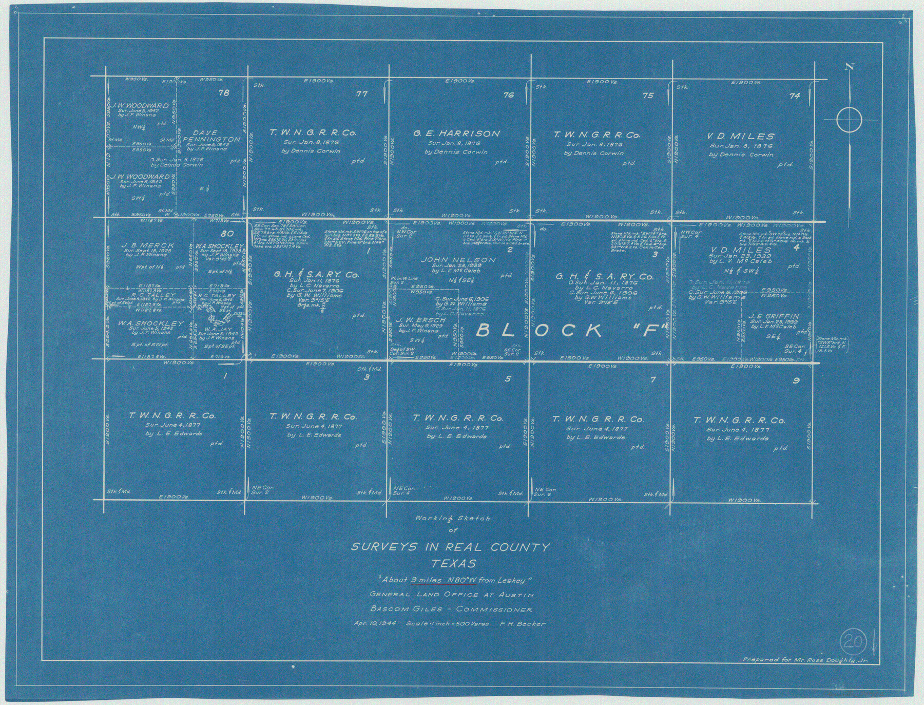
Real County Working Sketch 20
-
Map/Doc
71912
-
Collection
General Map Collection
-
Object Dates
4/10/1944 (Creation Date)
-
People and Organizations
F.H. Becker (Draftsman)
-
Counties
Real
-
Subjects
Surveying Working Sketch
-
Height x Width
19.0 x 24.9 inches
48.3 x 63.3 cm
-
Scale
1" = 500 varas
Part of: General Map Collection
Pecos County Sketch File 24

Print $22.00
- Digital $50.00
Pecos County Sketch File 24
Size 7.6 x 5.6 inches
Map/Doc 33680

Orange County Sabine River Leases 1,2,3,4

Print $20.00
- Digital $50.00
Orange County Sabine River Leases 1,2,3,4
1950
Size 36.5 x 22.4 inches
Map/Doc 1931
Red River County Working Sketch 52

Print $20.00
- Digital $50.00
Red River County Working Sketch 52
1971
Size 35.5 x 24.7 inches
Map/Doc 72035
Armstrong County Sketch File A-12

Print $40.00
- Digital $50.00
Armstrong County Sketch File A-12
Size 41.3 x 18.5 inches
Map/Doc 10374

Kaufman County Boundary File 6b

Print $6.00
- Digital $50.00
Kaufman County Boundary File 6b
Size 14.2 x 8.5 inches
Map/Doc 55966
Pecos County Working Sketch 31

Print $20.00
- Digital $50.00
Pecos County Working Sketch 31
1936
Size 17.5 x 22.4 inches
Map/Doc 71503
Jackson County Sketch File 29

Print $10.00
- Digital $50.00
Jackson County Sketch File 29
Size 13.4 x 8.7 inches
Map/Doc 27725
Map of Polk Co.

Print $40.00
- Digital $50.00
Map of Polk Co.
1906
Size 52.0 x 43.0 inches
Map/Doc 16789
San Saba County Working Sketch 5

Print $20.00
- Digital $50.00
San Saba County Working Sketch 5
1945
Size 30.5 x 22.9 inches
Map/Doc 63793

You may also like
Flight Mission No. DAG-17K, Frame 119, Matagorda County

Print $20.00
- Digital $50.00
Flight Mission No. DAG-17K, Frame 119, Matagorda County
1952
Size 16.4 x 16.5 inches
Map/Doc 86339
Flight Mission No. DIX-5P, Frame 102, Aransas County

Print $20.00
- Digital $50.00
Flight Mission No. DIX-5P, Frame 102, Aransas County
1956
Size 17.7 x 18.0 inches
Map/Doc 83780
Kendall County Boundary File 2b

Print $4.00
- Digital $50.00
Kendall County Boundary File 2b
Size 10.0 x 8.0 inches
Map/Doc 55754
Stonewall County Sketch File 8

Print $14.00
- Digital $50.00
Stonewall County Sketch File 8
1896
Size 8.7 x 7.7 inches
Map/Doc 37222
Brazoria County Working Sketch 20

Print $40.00
- Digital $50.00
Brazoria County Working Sketch 20
1951
Size 50.3 x 42.9 inches
Map/Doc 67505
Deaf Smith County, Texas / [Sec. 144, Blk. K-5]
![90623, Deaf Smith County, Texas / [Sec. 144, Blk. K-5], Twichell Survey Records](https://historictexasmaps.com/wmedia_w700/maps/90623-1.tif.jpg)
Print $20.00
- Digital $50.00
Deaf Smith County, Texas / [Sec. 144, Blk. K-5]
Size 22.9 x 22.8 inches
Map/Doc 90623
[Jas. T. Williams Survey and vicinity]
![91264, [Jas. T. Williams Survey and vicinity], Twichell Survey Records](https://historictexasmaps.com/wmedia_w700/maps/91264-1.tif.jpg)
Print $20.00
- Digital $50.00
[Jas. T. Williams Survey and vicinity]
Size 15.0 x 12.0 inches
Map/Doc 91264
Trinity River, Rockwall Sheet/East Fork of Trinity River

Print $4.00
- Digital $50.00
Trinity River, Rockwall Sheet/East Fork of Trinity River
1936
Size 29.6 x 22.9 inches
Map/Doc 65193

Vias de Comunicacion y Movimiento Maritimo

Print $20.00
- Digital $50.00
Vias de Comunicacion y Movimiento Maritimo
Size 26.1 x 34.2 inches
Map/Doc 96800
Val Verde County Rolled Sketch 62

Print $40.00
- Digital $50.00
Val Verde County Rolled Sketch 62
1956
Size 34.6 x 52.1 inches
Map/Doc 10081
Texas 1972 Official Highway Travel Map

Digital $50.00
Texas 1972 Official Highway Travel Map
Size 28.2 x 36.4 inches
Map/Doc 94314