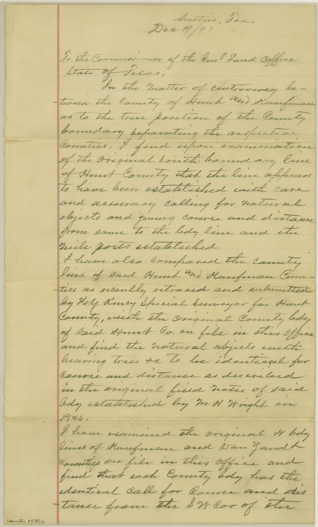
Kaufman County Boundary File 6b
[Draftsman's Statement]
-
Map/Doc
55966
-
Collection
General Map Collection
-
Counties
Kaufman
-
Subjects
County Boundaries
-
Height x Width
14.2 x 8.5 inches
36.1 x 21.6 cm
Part of: General Map Collection
Flight Mission No. DQN-6K, Frame 88, Calhoun County

Print $20.00
- Digital $50.00
Flight Mission No. DQN-6K, Frame 88, Calhoun County
1953
Size 18.7 x 22.3 inches
Map/Doc 84448
Armstrong County Working Sketch 2

Print $20.00
- Digital $50.00
Armstrong County Working Sketch 2
1904
Size 29.0 x 23.4 inches
Map/Doc 67233
Crockett County Sketch File 57

Print $22.00
- Digital $50.00
Crockett County Sketch File 57
Size 12.2 x 8.9 inches
Map/Doc 19832
Flight Mission No. DCL-6C, Frame 173, Kenedy County

Print $20.00
- Digital $50.00
Flight Mission No. DCL-6C, Frame 173, Kenedy County
1943
Size 18.6 x 22.4 inches
Map/Doc 85985
Ramon de la Garza 11 Leagues Houston and Robertson Districts

Print $2.00
- Digital $50.00
Ramon de la Garza 11 Leagues Houston and Robertson Districts
Size 11.5 x 8.5 inches
Map/Doc 181
Cameron County Rolled Sketch 28

Print $40.00
- Digital $50.00
Cameron County Rolled Sketch 28
1986
Size 36.5 x 48.3 inches
Map/Doc 8575
Flight Mission No. DCL-7C, Frame 28, Kenedy County

Print $20.00
- Digital $50.00
Flight Mission No. DCL-7C, Frame 28, Kenedy County
1943
Size 15.4 x 15.4 inches
Map/Doc 86020
Old Miscellaneous File 11

Print $4.00
- Digital $50.00
Old Miscellaneous File 11
1886
Size 11.2 x 8.8 inches
Map/Doc 75437
Travis County Working Sketch 3

Print $20.00
- Digital $50.00
Travis County Working Sketch 3
1906
Size 19.5 x 15.0 inches
Map/Doc 69387
Bandera County Working Sketch 33

Print $20.00
- Digital $50.00
Bandera County Working Sketch 33
1961
Size 22.4 x 28.8 inches
Map/Doc 67629
Jack County Sketch File 8a

Print $6.00
- Digital $50.00
Jack County Sketch File 8a
1855
Size 8.1 x 10.6 inches
Map/Doc 27519
Coke County Sketch File 12

Print $8.00
- Digital $50.00
Coke County Sketch File 12
Size 9.4 x 8.0 inches
Map/Doc 18592
You may also like
A Map of the British Empire in America with the French and Spanish Settlements adjacent thereto

Print $20.00
- Digital $50.00
A Map of the British Empire in America with the French and Spanish Settlements adjacent thereto
1733
Size 20.7 x 20.6 inches
Map/Doc 95704
Lampasas County Working Sketch 18

Print $20.00
- Digital $50.00
Lampasas County Working Sketch 18
1977
Size 46.1 x 44.0 inches
Map/Doc 70295
[Sketch for Mineral Application 26501 - Sabine River, T. A. Oldhausen]
![2844, [Sketch for Mineral Application 26501 - Sabine River, T. A. Oldhausen], General Map Collection](https://historictexasmaps.com/wmedia_w700/maps/2844.tif.jpg)
Print $20.00
- Digital $50.00
[Sketch for Mineral Application 26501 - Sabine River, T. A. Oldhausen]
1931
Size 24.4 x 36.8 inches
Map/Doc 2844
Duval County Rolled Sketch 20

Print $20.00
- Digital $50.00
Duval County Rolled Sketch 20
Size 33.2 x 42.0 inches
Map/Doc 8811
Clay County Sketch File 21

Print $2.00
- Digital $50.00
Clay County Sketch File 21
1882
Size 11.3 x 8.7 inches
Map/Doc 18435
Presidio County Rolled Sketch 33

Print $40.00
- Digital $50.00
Presidio County Rolled Sketch 33
Size 57.7 x 42.3 inches
Map/Doc 9772
Bee County Working Sketch 9

Print $20.00
- Digital $50.00
Bee County Working Sketch 9
1940
Size 15.6 x 16.8 inches
Map/Doc 67259
Upton County Working Sketch 24

Print $20.00
- Digital $50.00
Upton County Working Sketch 24
1953
Size 36.7 x 39.2 inches
Map/Doc 69520
Jackson County Sketch File 12a

Print $40.00
- Digital $50.00
Jackson County Sketch File 12a
Size 17.4 x 14.4 inches
Map/Doc 27658
Motley County Working Sketch 2

Print $20.00
- Digital $50.00
Motley County Working Sketch 2
1895
Size 17.3 x 21.3 inches
Map/Doc 71207
McCulloch County Rolled Sketch 7

Print $20.00
- Digital $50.00
McCulloch County Rolled Sketch 7
1982
Size 20.7 x 30.5 inches
Map/Doc 6718
Shelby County Rolled Sketch 3

Print $40.00
- Digital $50.00
Shelby County Rolled Sketch 3
Size 54.2 x 37.0 inches
Map/Doc 9919