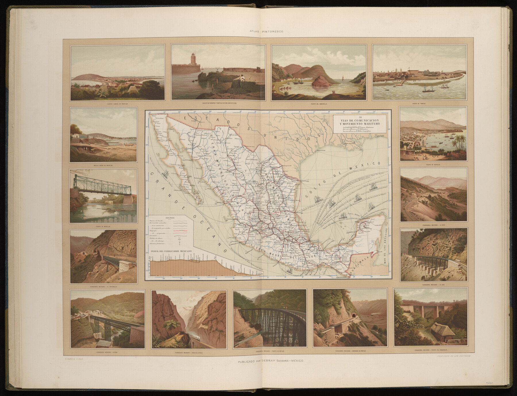
Vias de Comunicacion y Movimiento Maritimo
-
Map/Doc
96800
-
Collection
General Map Collection
-
Object Dates
1897 (Publication Date)
-
People and Organizations
Debray Sucesores (Publisher)
Antonio Garcia Cubas (Cartographer)
-
Subjects
Atlas Mexico
-
Height x Width
26.1 x 34.2 inches
66.3 x 86.9 cm
-
Medium
paper, etching/engraving/lithograph
-
Comments
Map 4 of 13 from "Atlas Pintoresco e Historico de los Estados Unidos Mexicanos" (96796 - PDF)
Related maps
Atlas Pintoresco e Historico de los Estados Unidos Mexicanos

Atlas Pintoresco e Historico de los Estados Unidos Mexicanos
Map/Doc 96796
Part of: General Map Collection
[Map showing resurvey of Capitol Leagues in Hartley & Dallam Counties, Texas]
![1753, [Map showing resurvey of Capitol Leagues in Hartley & Dallam Counties, Texas], General Map Collection](https://historictexasmaps.com/wmedia_w700/maps/1753-1.tif.jpg)
Print $40.00
- Digital $50.00
[Map showing resurvey of Capitol Leagues in Hartley & Dallam Counties, Texas]
1918
Size 66.9 x 31.0 inches
Map/Doc 1753
Flight Mission No. BRA-8M, Frame 135, Jefferson County

Print $20.00
- Digital $50.00
Flight Mission No. BRA-8M, Frame 135, Jefferson County
1953
Size 18.7 x 22.3 inches
Map/Doc 85631
Wheeler County Working Sketch 2

Print $40.00
- Digital $50.00
Wheeler County Working Sketch 2
1957
Size 35.2 x 58.5 inches
Map/Doc 72491
Jefferson County Rolled Sketch 25

Print $20.00
- Digital $50.00
Jefferson County Rolled Sketch 25
1939
Size 43.4 x 36.0 inches
Map/Doc 9290
Lynn County Sketch File 18

Print $4.00
- Digital $50.00
Lynn County Sketch File 18
1940
Size 11.2 x 8.8 inches
Map/Doc 30514
Bandera County Working Sketch 8

Print $20.00
- Digital $50.00
Bandera County Working Sketch 8
1920
Size 16.6 x 20.8 inches
Map/Doc 67601
Navigation Maps of Gulf Intracoastal Waterway, Port Arthur to Brownsville, Texas

Print $4.00
- Digital $50.00
Navigation Maps of Gulf Intracoastal Waterway, Port Arthur to Brownsville, Texas
1951
Size 16.6 x 21.3 inches
Map/Doc 65451
Cottle County Sketch File 8

Print $20.00
- Digital $50.00
Cottle County Sketch File 8
1894
Size 37.6 x 17.6 inches
Map/Doc 11192
Donley County Working Sketch 4

Print $20.00
- Digital $50.00
Donley County Working Sketch 4
1958
Size 44.0 x 39.8 inches
Map/Doc 68737
Floyd County Sketch File 7

Print $4.00
- Digital $50.00
Floyd County Sketch File 7
Size 8.9 x 14.3 inches
Map/Doc 22697
Culberson County Working Sketch 59

Print $20.00
- Digital $50.00
Culberson County Working Sketch 59
1974
Size 46.4 x 37.7 inches
Map/Doc 68513
Brewster County Working Sketch 106

Print $20.00
- Digital $50.00
Brewster County Working Sketch 106
1980
Size 43.3 x 31.8 inches
Map/Doc 67706
You may also like
Cottle County Working Sketch 13

Print $20.00
- Digital $50.00
Cottle County Working Sketch 13
1960
Size 19.6 x 25.0 inches
Map/Doc 68323

Liberty County Sketch File 19

Print $6.00
- Digital $50.00
Liberty County Sketch File 19
1859
Size 13.6 x 9.4 inches
Map/Doc 29923
Map of the Texas & Pacific Ry. Reserve West of the Pecos River

Print $40.00
- Digital $50.00
Map of the Texas & Pacific Ry. Reserve West of the Pecos River
1879
Size 55.4 x 118.1 inches
Map/Doc 96439
San Saba County Sketch File 12

Print $6.00
- Digital $50.00
San Saba County Sketch File 12
Size 11.8 x 9.3 inches
Map/Doc 36439
Flight Mission No. CUG-3P, Frame 93, Kleberg County

Print $20.00
- Digital $50.00
Flight Mission No. CUG-3P, Frame 93, Kleberg County
1956
Size 18.5 x 22.2 inches
Map/Doc 86263
[Block 1 PO, Surveys 15, 16, and 17]
![91433, [Block 1 PO, Surveys 15, 16, and 17], Twichell Survey Records](https://historictexasmaps.com/wmedia_w700/maps/91433-1.tif.jpg)
Print $20.00
- Digital $50.00
[Block 1 PO, Surveys 15, 16, and 17]
1906
Size 16.6 x 15.6 inches
Map/Doc 91433
Reeves County Working Sketch 25

Print $40.00
- Digital $50.00
Reeves County Working Sketch 25
1966
Size 31.4 x 59.0 inches
Map/Doc 63468
Plat Showing Block Z, W. D. and F. W. Johnson Subdivision, Bailey County, Texas

Print $20.00
- Digital $50.00
Plat Showing Block Z, W. D. and F. W. Johnson Subdivision, Bailey County, Texas
1955
Size 24.3 x 15.7 inches
Map/Doc 92538

Harris County Rolled Sketch WB

Print $20.00
- Digital $50.00
Harris County Rolled Sketch WB
1916
Size 15.5 x 21.1 inches
Map/Doc 6147
[S. C. Vineyard and Adjacent Surveys, Aransas County, Texas]
![82558, [S. C. Vineyard and Adjacent Surveys, Aransas County, Texas], Maddox Collection](https://historictexasmaps.com/wmedia_w700/maps/82558.tif.jpg)
Print $20.00
- Digital $50.00
[S. C. Vineyard and Adjacent Surveys, Aransas County, Texas]
Size 24.7 x 18.6 inches
Map/Doc 82558