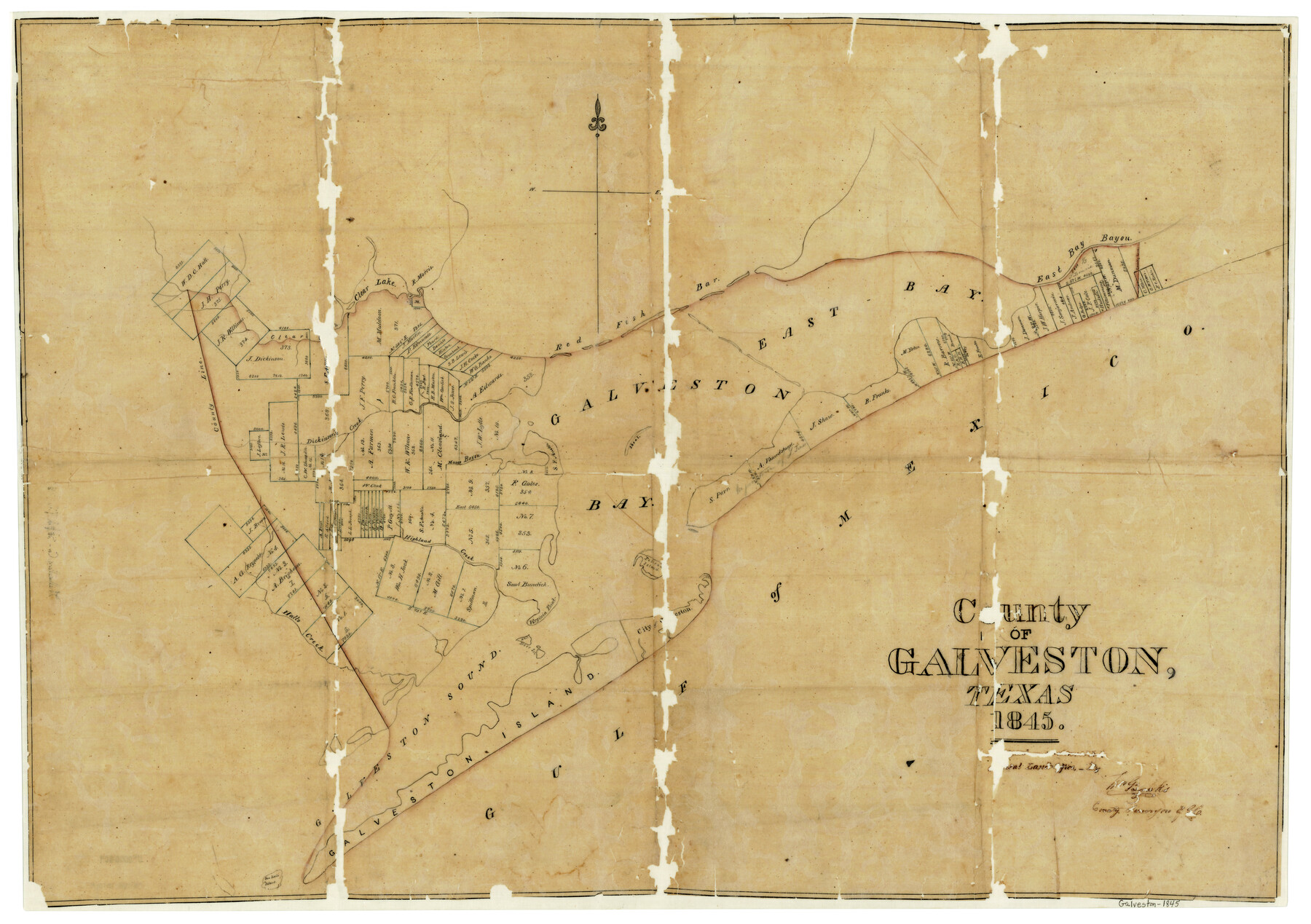
County of Galveston, Texas
-
Map/Doc
3574
-
Collection
General Map Collection
-
Object Dates
1845 (Creation Date)
-
People and Organizations
William G. Brooks (Surveyor/Engineer)
-
Counties
Galveston
-
Subjects
County
-
Height x Width
22.9 x 32.2 inches
58.2 x 81.8 cm
-
Features
Halls Creek
Clear Lake
Clear Creek
Moses Bayou
Dickinson's Creek
Virginia Point
Pelican Island
Deer Island
Highland Creek
Galveston Bay
Galveston
Galveston Island
Galveston Sound
Gulf of Mexico
San Luis Island
East Bay Bayou
Red Fish Bar
East Bay
Part of: General Map Collection
Harris County Working Sketch 118

Print $20.00
- Digital $50.00
Harris County Working Sketch 118
1984
Size 24.1 x 34.8 inches
Map/Doc 66010
Fort Bend County Working Sketch 31

Print $20.00
- Digital $50.00
Fort Bend County Working Sketch 31
1984
Size 28.9 x 16.0 inches
Map/Doc 69237
Parker County Working Sketch 4

Print $20.00
- Digital $50.00
Parker County Working Sketch 4
1941
Map/Doc 71454
Flight Mission No. BQY-14M, Frame 183, Harris County

Print $20.00
- Digital $50.00
Flight Mission No. BQY-14M, Frame 183, Harris County
1953
Size 18.5 x 22.4 inches
Map/Doc 85299
Atascosa County Sketch File 3b

Print $8.00
- Digital $50.00
Atascosa County Sketch File 3b
1857
Size 11.4 x 5.8 inches
Map/Doc 13739
Pecos County Working Sketch 108

Print $40.00
- Digital $50.00
Pecos County Working Sketch 108
1971
Size 43.5 x 56.3 inches
Map/Doc 71581
Palo Pinto County Sketch File 6

Print $40.00
- Digital $50.00
Palo Pinto County Sketch File 6
1875
Size 9.3 x 18.8 inches
Map/Doc 33396

Red River County Working Sketch 56

Print $20.00
- Digital $50.00
Red River County Working Sketch 56
1971
Size 30.1 x 35.2 inches
Map/Doc 72039
Map of Comanche Co.

Print $20.00
- Digital $50.00
Map of Comanche Co.
1896
Size 39.3 x 43.1 inches
Map/Doc 66782
Sutton County Sketch File 19

Print $8.00
- Digital $50.00
Sutton County Sketch File 19
1914
Size 11.4 x 8.8 inches
Map/Doc 37447
Map of Cameron County Drainage District Number One

Print $20.00
- Digital $50.00
Map of Cameron County Drainage District Number One
1929
Size 46.6 x 31.0 inches
Map/Doc 94245
You may also like
[Beaumont, Sour Lake and Western Ry. Right of Way and Alignment - Frisco]
![64120, [Beaumont, Sour Lake and Western Ry. Right of Way and Alignment - Frisco], General Map Collection](https://historictexasmaps.com/wmedia_w700/maps/64120.tif.jpg)
Print $20.00
- Digital $50.00
[Beaumont, Sour Lake and Western Ry. Right of Way and Alignment - Frisco]
1910
Size 19.7 x 45.6 inches
Map/Doc 64120
Map showing conflict of Rusk Transportation Co. with Lazarus and I. R.R. Co. Surveys

Print $20.00
- Digital $50.00
Map showing conflict of Rusk Transportation Co. with Lazarus and I. R.R. Co. Surveys
1914
Size 28.9 x 16.6 inches
Map/Doc 75825
Map of Caldwell County, Texas

Print $20.00
Map of Caldwell County, Texas
1879
Size 17.4 x 21.5 inches
Map/Doc 88914
Presidio County Rolled Sketch 139

Print $20.00
- Digital $50.00
Presidio County Rolled Sketch 139
2002
Size 24.5 x 27.5 inches
Map/Doc 78647
Greer County Sketch File 2

Print $20.00
- Digital $50.00
Greer County Sketch File 2
1883
Size 25.4 x 19.9 inches
Map/Doc 11582
Terrell County Rolled Sketch 39

Print $20.00
- Digital $50.00
Terrell County Rolled Sketch 39
1941
Size 18.7 x 42.9 inches
Map/Doc 7943
Rusk County Working Sketch 38

Print $20.00
- Digital $50.00
Rusk County Working Sketch 38
2008
Size 16.3 x 23.3 inches
Map/Doc 88815
[Sketch showing H. & T. C. R. R. Co. Blk. 48, S. P. R. R. Co. Blk. I, and E. T. R. R. Co. Blk. I]
![89647, [Sketch showing H. & T. C. R. R. Co. Blk. 48, S. P. R. R. Co. Blk. I, and E. T. R. R. Co. Blk. I], Twichell Survey Records](https://historictexasmaps.com/wmedia_w700/maps/89647-1.tif.jpg)
Print $40.00
- Digital $50.00
[Sketch showing H. & T. C. R. R. Co. Blk. 48, S. P. R. R. Co. Blk. I, and E. T. R. R. Co. Blk. I]
Size 51.4 x 9.2 inches
Map/Doc 89647

G. P. Co. Survey of A. C. Daws Tr. Lease No. 6453

Print $20.00
- Digital $50.00
G. P. Co. Survey of A. C. Daws Tr. Lease No. 6453
1920
Size 18.9 x 27.9 inches
Map/Doc 92022
[Gunter & Munson, Maddox Bros. & Anderson Block O]
![91946, [Gunter & Munson, Maddox Bros. & Anderson Block O], Twichell Survey Records](https://historictexasmaps.com/wmedia_w700/maps/91946-1.tif.jpg)
Print $20.00
- Digital $50.00
[Gunter & Munson, Maddox Bros. & Anderson Block O]
Size 25.8 x 40.6 inches
Map/Doc 91946
Crosbyton (Jeff Williams Plan)

Print $20.00
- Digital $50.00
Crosbyton (Jeff Williams Plan)
Size 26.0 x 18.2 inches
Map/Doc 92126