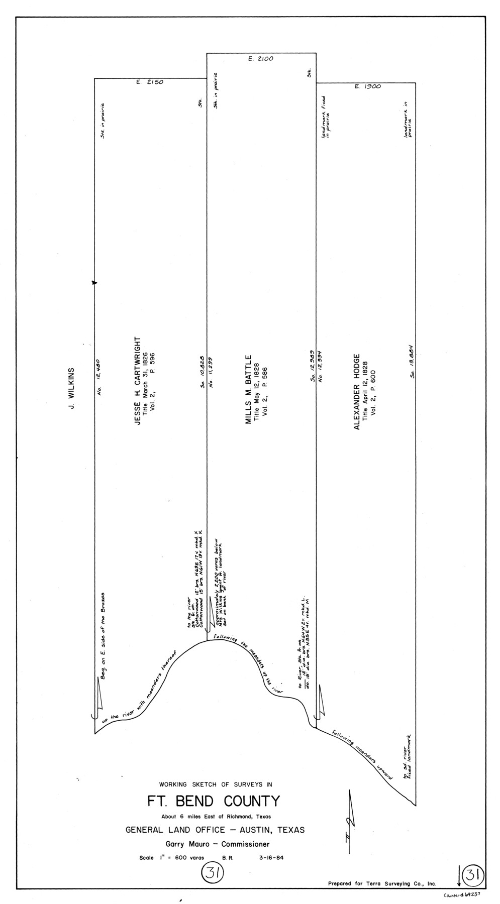
Fort Bend County Working Sketch 31
-
Map/Doc
69237
-
Collection
General Map Collection
-
Object Dates
3/16/1984 (Creation Date)
-
People and Organizations
Beverly Robison (Draftsman)
-
Counties
Fort Bend
-
Subjects
Surveying Working Sketch
-
Height x Width
28.9 x 16.0 inches
73.4 x 40.6 cm
-
Scale
1" = 600 varas
Part of: General Map Collection
Flight Mission No. DAG-18K, Frame 183, Matagorda County

Print $20.00
- Digital $50.00
Flight Mission No. DAG-18K, Frame 183, Matagorda County
1952
Size 16.0 x 16.0 inches
Map/Doc 86375
Jasper County Rolled Sketch 9

Print $83.00
- Digital $50.00
Jasper County Rolled Sketch 9
1932
Size 10.7 x 15.4 inches
Map/Doc 46171
Shackelford County Working Sketch 6

Print $20.00
- Digital $50.00
Shackelford County Working Sketch 6
1963
Size 26.1 x 28.9 inches
Map/Doc 63846
Kendall County Working Sketch 23

Print $20.00
- Digital $50.00
Kendall County Working Sketch 23
1974
Size 21.7 x 24.5 inches
Map/Doc 66695
Map of Runnels County

Print $20.00
- Digital $50.00
Map of Runnels County
1879
Size 25.9 x 18.5 inches
Map/Doc 4620
Harris County Working Sketch 105

Print $20.00
- Digital $50.00
Harris County Working Sketch 105
1980
Size 36.6 x 44.9 inches
Map/Doc 65997
Webb County Rolled Sketch 52

Print $20.00
- Digital $50.00
Webb County Rolled Sketch 52
1943
Size 37.8 x 29.3 inches
Map/Doc 8205
Stephens County Sketch File 10c

Print $6.00
- Digital $50.00
Stephens County Sketch File 10c
Size 7.8 x 11.5 inches
Map/Doc 37052
Jackson County Working Sketch 14

Print $20.00
- Digital $50.00
Jackson County Working Sketch 14
1990
Size 31.7 x 32.2 inches
Map/Doc 66462
Henderson County Sketch File 12

Print $8.00
- Digital $50.00
Henderson County Sketch File 12
1871
Size 8.4 x 7.4 inches
Map/Doc 26349
McMullen County Sketch File 22

Print $4.00
- Digital $50.00
McMullen County Sketch File 22
Size 10.0 x 8.1 inches
Map/Doc 31377
San Saba County Sketch File 7a

Print $6.00
- Digital $50.00
San Saba County Sketch File 7a
1883
Size 16.4 x 10.5 inches
Map/Doc 36428
You may also like
Grayson County Boundary File 5

Print $4.00
- Digital $50.00
Grayson County Boundary File 5
Size 11.2 x 8.7 inches
Map/Doc 53959
[Unorganized County School Land Leagues 284 - 317]
![90854, [Unorganized County School Land Leagues 284 - 317], Twichell Survey Records](https://historictexasmaps.com/wmedia_w700/maps/90854-2.tif.jpg)
Print $20.00
- Digital $50.00
[Unorganized County School Land Leagues 284 - 317]
1902
Size 29.2 x 21.3 inches
Map/Doc 90854
Kleberg County Rolled Sketch 10-1

Print $20.00
- Digital $50.00
Kleberg County Rolled Sketch 10-1
1951
Size 36.9 x 32.2 inches
Map/Doc 9383
Carte Reduite du Golphe du Mexique et des isles de l'Amerique dressée au depost des cartes et plans de la Marine pour le service des vaisseaux du Roy

Print $20.00
- Digital $50.00
Carte Reduite du Golphe du Mexique et des isles de l'Amerique dressée au depost des cartes et plans de la Marine pour le service des vaisseaux du Roy
1774
Size 25.5 x 32.9 inches
Map/Doc 94097
Your Opportunity - the Magic Valley - Money Will Grow on Trees! Learn Where How and Why!

Your Opportunity - the Magic Valley - Money Will Grow on Trees! Learn Where How and Why!
1928
Map/Doc 96740
Plat of the Resubdivision of the Abandoned Townsite of Eschiti, Oklahoma

Print $4.00
- Digital $50.00
Plat of the Resubdivision of the Abandoned Townsite of Eschiti, Oklahoma
1907
Size 18.1 x 24.3 inches
Map/Doc 75150
Gillespie County Sketch File 16

Print $20.00
- Digital $50.00
Gillespie County Sketch File 16
1951
Size 18.2 x 17.9 inches
Map/Doc 11557
Burleson County Working Sketch 16

Print $3.00
- Digital $50.00
Burleson County Working Sketch 16
1980
Size 10.1 x 14.1 inches
Map/Doc 67735

Coleman County Working Sketch Graphic Index

Print $40.00
- Digital $50.00
Coleman County Working Sketch Graphic Index
1945
Size 54.0 x 36.3 inches
Map/Doc 76497
Bastrop County Boundary File 5

Print $18.00
- Digital $50.00
Bastrop County Boundary File 5
Size 9.1 x 7.2 inches
Map/Doc 50328
Grayson County Sketch File 12

Print $4.00
- Digital $50.00
Grayson County Sketch File 12
1853
Size 12.8 x 8.4 inches
Map/Doc 24478