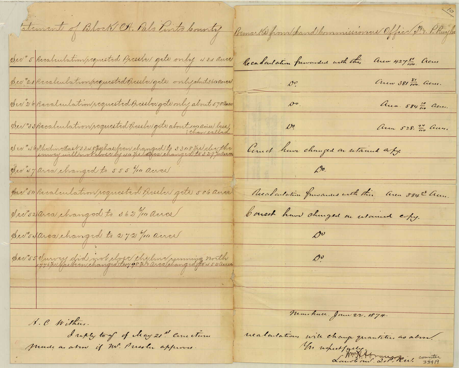
Palo Pinto County Sketch File 29
[Calculations on T. & P. surveys in Blocks A, 1, and 2]
-
Map/Doc
33419
-
Collection
General Map Collection
-
Object Dates
6/22/1874 (Creation Date)
12/3/1984 (File Date)
-
People and Organizations
William H. Abrams (Surveyor/Engineer)
-
Counties
Palo Pinto
-
Subjects
Surveying Sketch File
-
Height x Width
12.8 x 16.0 inches
32.5 x 40.6 cm
-
Medium
paper, manuscript
Part of: General Map Collection
Brewster County Rolled Sketch 114

Print $20.00
- Digital $50.00
Brewster County Rolled Sketch 114
1964
Size 11.4 x 18.2 inches
Map/Doc 5282
Midland County Rolled Sketch 12

Print $40.00
- Digital $50.00
Midland County Rolled Sketch 12
Size 97.0 x 42.6 inches
Map/Doc 9520
Flight Mission No. BQR-5K, Frame 63, Brazoria County

Print $20.00
- Digital $50.00
Flight Mission No. BQR-5K, Frame 63, Brazoria County
1952
Size 19.0 x 22.6 inches
Map/Doc 84008
Falls County Sketch File 2a

Print $2.00
- Digital $50.00
Falls County Sketch File 2a
1856
Size 8.4 x 10.9 inches
Map/Doc 22334
San Augustine County Working Sketch 8

Print $20.00
- Digital $50.00
San Augustine County Working Sketch 8
1935
Size 24.8 x 35.0 inches
Map/Doc 63695
Shelby County Working Sketch 10

Print $20.00
- Digital $50.00
Shelby County Working Sketch 10
1945
Size 42.8 x 43.9 inches
Map/Doc 63863
Leon County Rolled Sketch 22

Print $20.00
- Digital $50.00
Leon County Rolled Sketch 22
1983
Size 29.9 x 27.1 inches
Map/Doc 6608
Texas, Copano Bay, Port Bay

Print $40.00
- Digital $50.00
Texas, Copano Bay, Port Bay
1934
Size 32.9 x 48.8 inches
Map/Doc 73432
Real County Sketch File 2

Print $4.00
- Digital $50.00
Real County Sketch File 2
1884
Size 13.4 x 8.5 inches
Map/Doc 35037
Culberson County Sketch File 45

Print $6.00
- Digital $50.00
Culberson County Sketch File 45
2002
Size 14.2 x 8.8 inches
Map/Doc 76367
Flight Mission No. BRA-7M, Frame 191, Jefferson County

Print $20.00
- Digital $50.00
Flight Mission No. BRA-7M, Frame 191, Jefferson County
1953
Size 18.6 x 22.4 inches
Map/Doc 85559
Hays County Sketch File 19

Print $6.00
- Digital $50.00
Hays County Sketch File 19
Size 8.5 x 6.7 inches
Map/Doc 26237
You may also like
Webb County Working Sketch 86

Print $20.00
- Digital $50.00
Webb County Working Sketch 86
1981
Size 44.3 x 37.0 inches
Map/Doc 72453
Comanche County Rolled Sketch 3

Print $20.00
- Digital $50.00
Comanche County Rolled Sketch 3
2017
Size 35.1 x 44.9 inches
Map/Doc 95384
Pecos County Working Sketch 30

Print $20.00
- Digital $50.00
Pecos County Working Sketch 30
1936
Size 27.9 x 27.4 inches
Map/Doc 71502
Red River County Rolled Sketch 3

Print $20.00
- Digital $50.00
Red River County Rolled Sketch 3
Size 36.9 x 31.0 inches
Map/Doc 9840
Mason County Boundary File 1

Print $2.00
- Digital $50.00
Mason County Boundary File 1
Size 12.7 x 8.2 inches
Map/Doc 56829

Val Verde County

Print $20.00
- Digital $50.00
Val Verde County
1944
Size 40.0 x 36.2 inches
Map/Doc 77445
Dimmit County Boundary File 10a

Print $4.00
- Digital $50.00
Dimmit County Boundary File 10a
Size 14.0 x 8.5 inches
Map/Doc 52611
[Working Sketch Survey 46]
![90955, [Working Sketch Survey 46], Twichell Survey Records](https://historictexasmaps.com/wmedia_w700/maps/90955-1.tif.jpg)
Print $20.00
- Digital $50.00
[Working Sketch Survey 46]
Size 19.0 x 11.8 inches
Map/Doc 90955
Val Verde County Working Sketch 39

Print $20.00
- Digital $50.00
Val Verde County Working Sketch 39
1943
Size 26.0 x 26.5 inches
Map/Doc 72174
Crosby County Rolled Sketch D

Print $20.00
- Digital $50.00
Crosby County Rolled Sketch D
Size 23.9 x 23.6 inches
Map/Doc 5643
[Sketch in vicinity of Wm. McCutcheon, S. H. Reid and John McGinley]
![90115, [Sketch in vicinity of Wm. McCutcheon, S. H. Reid and John McGinley], Twichell Survey Records](https://historictexasmaps.com/wmedia_w700/maps/90115-1.tif.jpg)
Print $20.00
- Digital $50.00
[Sketch in vicinity of Wm. McCutcheon, S. H. Reid and John McGinley]
1923
Size 20.0 x 13.2 inches
Map/Doc 90115