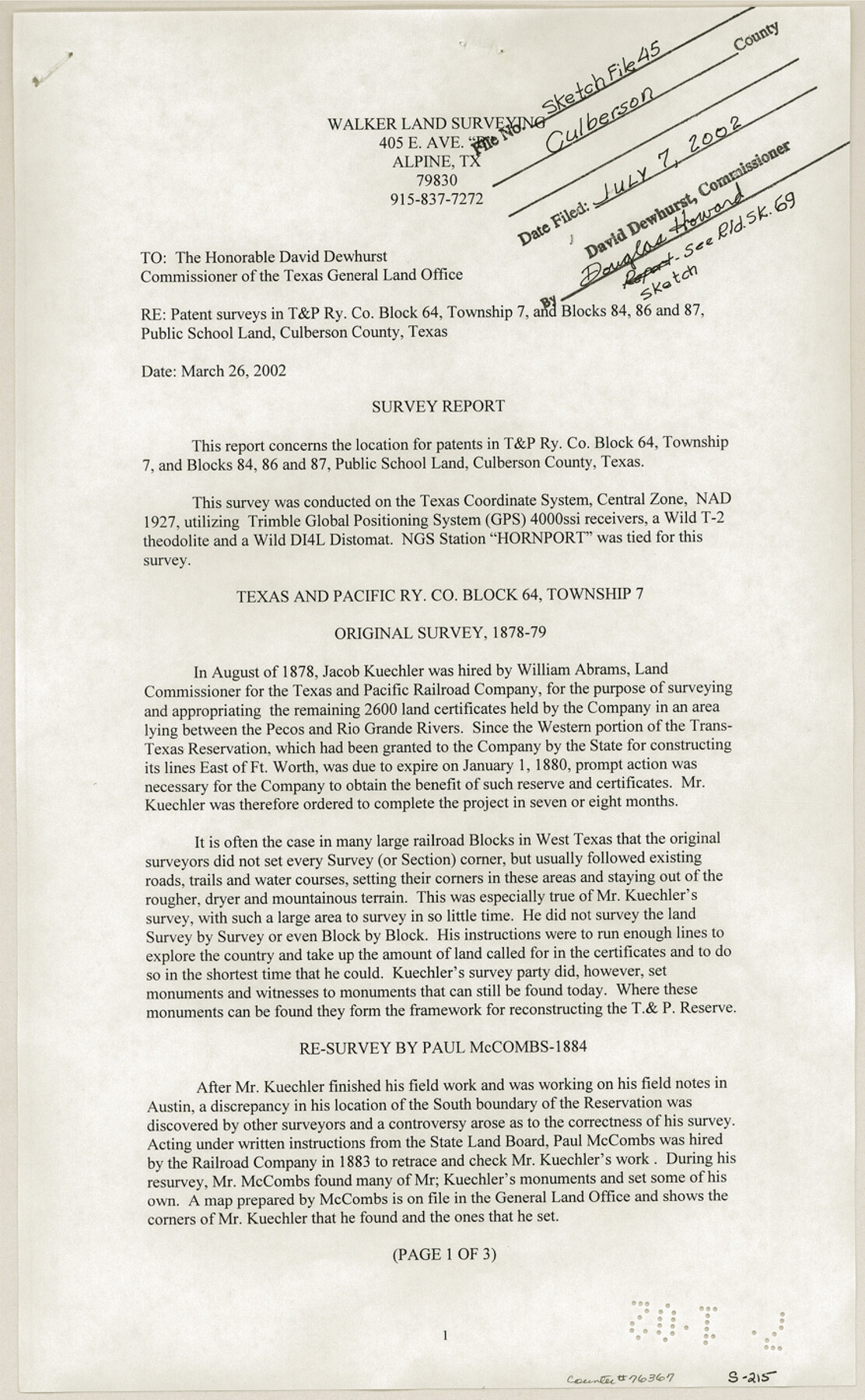
Culberson County Sketch File 45
[Survey report regarding patent surveys in T. & P. RR. Co. Block 64, Township 7 and Blocks 84, 86 and 87 Public School Land]
-
Map/Doc
76367
-
Collection
General Map Collection
-
Object Dates
2002/3/26 (Creation Date)
2002/7/7 (File Date)
-
People and Organizations
Steven F. Walker (Surveyor/Engineer)
Jacob Kuechler (Surveyor/Engineer)
Paul McCombs (Surveyor/Engineer)
A.H. Parker (Surveyor/Engineer)
R.W. Baker (Surveyor/Engineer)
Clifford Cool (Surveyor/Engineer)
-
Counties
Culberson
-
Subjects
Surveying Sketch File
-
Height x Width
14.2 x 8.8 inches
36.1 x 22.4 cm
-
Medium
paper, print
-
Comments
See Culberson County Rolled Sketch 69 (76425) for sketch.
-
Features
Pecos River
Rio Grande River
Related maps
Culberson County Rolled Sketch 69

Print $20.00
- Digital $50.00
Culberson County Rolled Sketch 69
Size 33.5 x 22.9 inches
Map/Doc 76425
Part of: General Map Collection
Port Aransas-Corpus Christi Waterway, Texas, Avery Point Turning Basin to Vicinity of Tule Lake - Dredging

Print $20.00
- Digital $50.00
Port Aransas-Corpus Christi Waterway, Texas, Avery Point Turning Basin to Vicinity of Tule Lake - Dredging
1947
Size 28.4 x 41.4 inches
Map/Doc 60302
Red River County Working Sketch 81-4

Print $20.00
- Digital $50.00
Red River County Working Sketch 81-4
1987
Size 21.8 x 16.7 inches
Map/Doc 72067
Kimble County Sketch File 38

Print $10.00
- Digital $50.00
Kimble County Sketch File 38
1989
Size 3.6 x 4.0 inches
Map/Doc 28992
Jefferson County Sketch File 44

Print $20.00
- Digital $50.00
Jefferson County Sketch File 44
1917
Size 22.8 x 32.9 inches
Map/Doc 11878
Jefferson County Working Sketch 41

Print $20.00
- Digital $50.00
Jefferson County Working Sketch 41
1985
Size 26.4 x 20.8 inches
Map/Doc 66585
Tyler County Sketch File 9a

Print $4.00
- Digital $50.00
Tyler County Sketch File 9a
1877
Size 8.1 x 7.7 inches
Map/Doc 38646
Bosque County Working Sketch 1

Print $20.00
- Digital $50.00
Bosque County Working Sketch 1
Size 16.3 x 13.7 inches
Map/Doc 67434
Map of Fort Bend Co.

Print $20.00
- Digital $50.00
Map of Fort Bend Co.
1898
Size 45.1 x 41.1 inches
Map/Doc 75965
Marion County Boundary File 1

Print $14.00
- Digital $50.00
Marion County Boundary File 1
Size 12.9 x 8.2 inches
Map/Doc 56822
Revised Map of West Half of Sabine Lake, Jefferson & Orange Cos., showing subdivision for mineral development

Print $40.00
- Digital $50.00
Revised Map of West Half of Sabine Lake, Jefferson & Orange Cos., showing subdivision for mineral development
1957
Size 58.9 x 42.0 inches
Map/Doc 2898
Lavaca County Sketch File 3

Print $8.00
- Digital $50.00
Lavaca County Sketch File 3
1853
Size 10.1 x 9.8 inches
Map/Doc 29633
Travis County Boundary File 6

Print $109.00
- Digital $50.00
Travis County Boundary File 6
Size 14.6 x 9.1 inches
Map/Doc 59433
You may also like

Webb County Working Sketch 25

Print $20.00
- Digital $50.00
Webb County Working Sketch 25
1928
Size 38.8 x 31.2 inches
Map/Doc 72390
Yoakum County Sketch File 11a

Print $20.00
- Digital $50.00
Yoakum County Sketch File 11a
Size 23.9 x 29.0 inches
Map/Doc 12708
Carte de la Louisiane cours du Mississipi et pais voisins dediée à M. le Comte de Maurepas, Ministre et Secretaire d'Etat Commandeur des Ordres du Roy

Print $20.00
- Digital $50.00
Carte de la Louisiane cours du Mississipi et pais voisins dediée à M. le Comte de Maurepas, Ministre et Secretaire d'Etat Commandeur des Ordres du Roy
1744
Size 17.5 x 23.3 inches
Map/Doc 94496
Concho, San Saba & Llano Valley Railway, Sterling City Branch, Texas. Right of Way and Track Map

Print $40.00
- Digital $50.00
Concho, San Saba & Llano Valley Railway, Sterling City Branch, Texas. Right of Way and Track Map
1910
Size 18.1 x 121.2 inches
Map/Doc 64438
Orange County NRC Article 33.136 Sketch 4

Print $24.00
- Digital $50.00
Orange County NRC Article 33.136 Sketch 4
2011
Size 22.6 x 31.2 inches
Map/Doc 93271
Foard County Working Sketch 3

Print $20.00
- Digital $50.00
Foard County Working Sketch 3
1933
Size 21.1 x 18.8 inches
Map/Doc 69193
Atascosa County Sketch File 34

Print $4.00
- Digital $50.00
Atascosa County Sketch File 34
Size 10.4 x 8.3 inches
Map/Doc 13827
Rockwall County Boundary File 8

Print $10.00
- Digital $50.00
Rockwall County Boundary File 8
Size 14.4 x 8.8 inches
Map/Doc 58428
Coleman County Sketch File 27

Print $4.00
- Digital $50.00
Coleman County Sketch File 27
1873
Size 12.8 x 8.0 inches
Map/Doc 18714
Archer County Rolled Sketch B2

Print $20.00
- Digital $50.00
Archer County Rolled Sketch B2
1891
Size 36.7 x 30.7 inches
Map/Doc 5105
Wheeler County Rolled Sketch 1

Print $20.00
- Digital $50.00
Wheeler County Rolled Sketch 1
1941
Size 43.9 x 23.7 inches
Map/Doc 10136