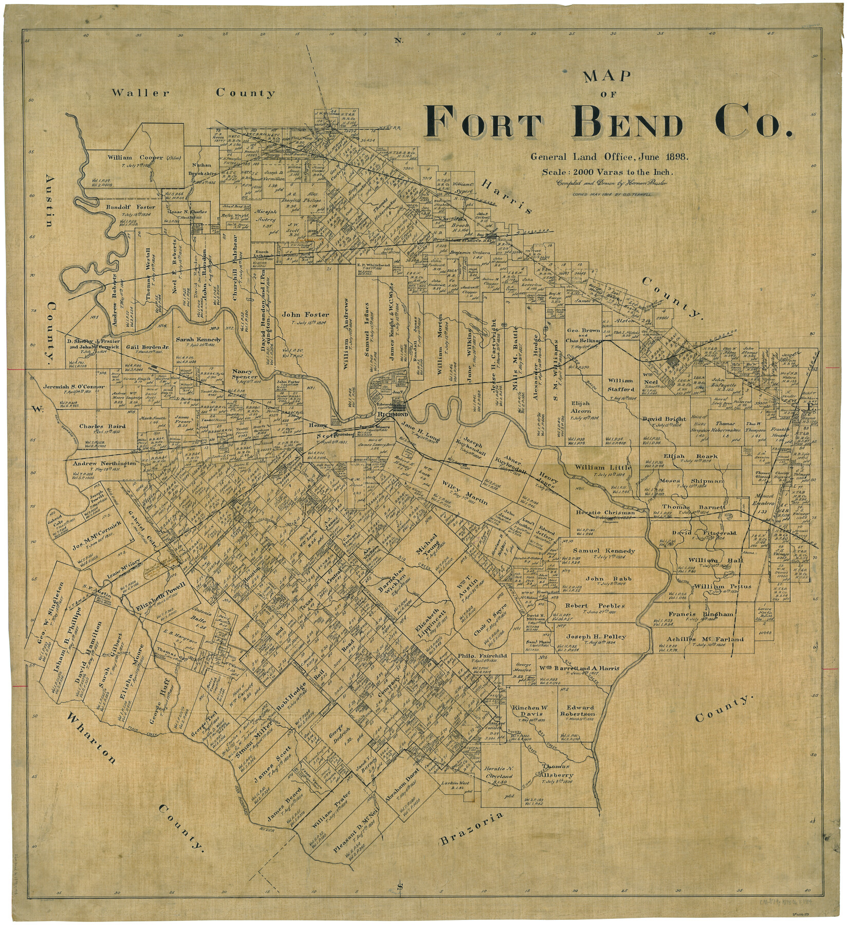
Map of Fort Bend Co.
-
Map/Doc
75965
-
Collection
General Map Collection
-
Object Dates
6/1898 (Creation Date)
5/1914 (Tracing Date)
-
People and Organizations
Texas General Land Office (Publisher)
Herman Pressler (Draftsman)
Otis O. Terrell (Tracer)
-
Counties
Fort Bend
-
Subjects
County
-
Height x Width
45.1 x 41.1 inches
114.6 x 104.4 cm
Part of: General Map Collection
Kimble County Working Sketch 7

Print $20.00
- Digital $50.00
Kimble County Working Sketch 7
1917
Size 12.6 x 16.8 inches
Map/Doc 70075
Crockett County Rolled Sketch 84

Print $20.00
- Digital $50.00
Crockett County Rolled Sketch 84
1961
Size 31.9 x 25.2 inches
Map/Doc 5624
Map of the First Division of the Chicago, Texas & Mexican-Central Railway

Print $40.00
- Digital $50.00
Map of the First Division of the Chicago, Texas & Mexican-Central Railway
Size 26.1 x 96.3 inches
Map/Doc 64467
A General Map of the Roman Empire Shewing the Situation of all its Provinces & ye Seats of ye Barbarous Nations on their Frontiers

Print $20.00
- Digital $50.00
A General Map of the Roman Empire Shewing the Situation of all its Provinces & ye Seats of ye Barbarous Nations on their Frontiers
1744
Size 10.8 x 20.5 inches
Map/Doc 96644
Val Verde County Working Sketch 25

Print $20.00
- Digital $50.00
Val Verde County Working Sketch 25
1934
Size 24.2 x 18.2 inches
Map/Doc 72160
Flight Mission No. DAH-17M, Frame 26, Orange County

Print $20.00
- Digital $50.00
Flight Mission No. DAH-17M, Frame 26, Orange County
1953
Size 18.3 x 22.3 inches
Map/Doc 86889
Presidio County Rolled Sketch 53

Print $20.00
- Digital $50.00
Presidio County Rolled Sketch 53
1911
Size 13.0 x 22.2 inches
Map/Doc 7346

Flight Mission No. BRA-16M, Frame 55, Jefferson County

Print $20.00
- Digital $50.00
Flight Mission No. BRA-16M, Frame 55, Jefferson County
1953
Size 18.4 x 22.4 inches
Map/Doc 85672
Trinity River, Bazzette Sheet

Print $20.00
- Digital $50.00
Trinity River, Bazzette Sheet
1925
Size 27.4 x 23.6 inches
Map/Doc 69692
Map of Hill County

Print $20.00
- Digital $50.00
Map of Hill County
1882
Size 21.6 x 25.5 inches
Map/Doc 3669
Flight Mission No. DQO-2K, Frame 89, Galveston County

Print $20.00
- Digital $50.00
Flight Mission No. DQO-2K, Frame 89, Galveston County
1952
Size 18.6 x 22.3 inches
Map/Doc 85016
You may also like

Flight Mission No. BRA-9M, Frame 72, Jefferson County

Print $20.00
- Digital $50.00
Flight Mission No. BRA-9M, Frame 72, Jefferson County
1953
Size 18.5 x 22.6 inches
Map/Doc 85655
Working Sketch in Stephens-Palo Pinto Cos.

Print $20.00
- Digital $50.00
Working Sketch in Stephens-Palo Pinto Cos.
1919
Size 22.3 x 13.3 inches
Map/Doc 91918
Hutchinson County Sketch File 5a

Print $6.00
- Digital $50.00
Hutchinson County Sketch File 5a
1900
Size 9.7 x 6.4 inches
Map/Doc 27195
Marion County Working Sketch 2

Print $20.00
- Digital $50.00
Marion County Working Sketch 2
Size 37.5 x 28.2 inches
Map/Doc 70777
Flight Mission No. DQN-2K, Frame 26, Calhoun County

Print $20.00
- Digital $50.00
Flight Mission No. DQN-2K, Frame 26, Calhoun County
1953
Size 18.6 x 22.2 inches
Map/Doc 84233
General Topographical Map. Sheet XXII

Print $20.00
- Digital $50.00
General Topographical Map. Sheet XXII
1891
Size 18.4 x 29.4 inches
Map/Doc 97526
[Sketch showing various surveys south and along Holiday Creek]
![89979, [Sketch showing various surveys south and along Holiday Creek], Twichell Survey Records](https://historictexasmaps.com/wmedia_w700/maps/89979-1.tif.jpg)
Print $20.00
- Digital $50.00
[Sketch showing various surveys south and along Holiday Creek]
Size 36.1 x 30.1 inches
Map/Doc 89979
Brewster County Working Sketch Graphic Index, North Part, Sheet 2 (Sketches 87 to Most Recent)

Print $20.00
- Digital $50.00
Brewster County Working Sketch Graphic Index, North Part, Sheet 2 (Sketches 87 to Most Recent)
1956
Size 41.8 x 39.5 inches
Map/Doc 76474
Flight Mission No. DAG-17K, Frame 63, Matagorda County

Print $20.00
- Digital $50.00
Flight Mission No. DAG-17K, Frame 63, Matagorda County
1952
Size 18.6 x 22.3 inches
Map/Doc 86325
Sutton County Sketch File E2

Print $20.00
- Digital $50.00
Sutton County Sketch File E2
Size 16.8 x 19.0 inches
Map/Doc 12397
Galveston County Working Sketch 6

Print $20.00
- Digital $50.00
Galveston County Working Sketch 6
1934
Size 43.5 x 38.0 inches
Map/Doc 69343