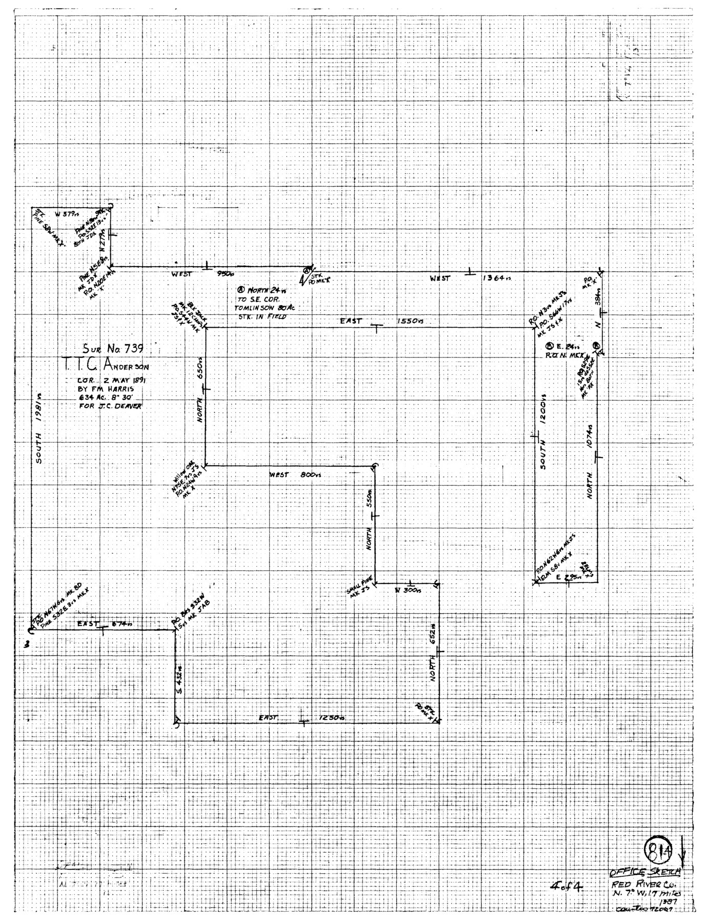
Red River County Working Sketch 81-4
-
Map/Doc
72067
-
Collection
General Map Collection
-
Object Dates
1987 (Creation Date)
-
Counties
Red River
-
Subjects
Surveying Working Sketch
-
Height x Width
21.8 x 16.7 inches
55.4 x 42.4 cm
Related maps
Red River County Working Sketch 81-1

Print $20.00
- Digital $50.00
Red River County Working Sketch 81-1
1987
Size 14.6 x 18.4 inches
Map/Doc 72064
Red River County Working Sketch 81-2

Print $20.00
- Digital $50.00
Red River County Working Sketch 81-2
1987
Size 14.6 x 18.6 inches
Map/Doc 72065
Red River County Working Sketch 81-3

Print $20.00
- Digital $50.00
Red River County Working Sketch 81-3
1987
Size 17.5 x 21.5 inches
Map/Doc 72066
Part of: General Map Collection
Reagan County Rolled Sketch 5

Print $20.00
- Digital $50.00
Reagan County Rolled Sketch 5
1928
Size 26.8 x 22.1 inches
Map/Doc 7434
Flight Mission No. CRC-2R, Frame 200, Chambers County

Print $20.00
- Digital $50.00
Flight Mission No. CRC-2R, Frame 200, Chambers County
1956
Size 18.8 x 22.4 inches
Map/Doc 84778
Flight Mission No. CUG-2P, Frame 70, Kleberg County

Print $20.00
- Digital $50.00
Flight Mission No. CUG-2P, Frame 70, Kleberg County
1956
Size 18.7 x 22.4 inches
Map/Doc 86207
Matagorda Light to Aransas Pass

Print $20.00
- Digital $50.00
Matagorda Light to Aransas Pass
1962
Size 35.7 x 44.8 inches
Map/Doc 73397
Freestone County Boundary File 30a

Print $10.00
- Digital $50.00
Freestone County Boundary File 30a
Size 14.1 x 8.8 inches
Map/Doc 53592
Rockwall County Working Sketch 3

Print $20.00
- Digital $50.00
Rockwall County Working Sketch 3
1923
Size 22.6 x 18.7 inches
Map/Doc 63595
A Geographically Correct Map of the State of Texas

Print $20.00
- Digital $50.00
A Geographically Correct Map of the State of Texas
1876
Size 20.4 x 21.9 inches
Map/Doc 95362
Wood County Working Sketch 2

Print $20.00
- Digital $50.00
Wood County Working Sketch 2
1913
Size 17.8 x 16.8 inches
Map/Doc 62002
Map of the World on a Globular Projection to illustrate Olney's school geography

Print $20.00
- Digital $50.00
Map of the World on a Globular Projection to illustrate Olney's school geography
1844
Size 12.1 x 19.0 inches
Map/Doc 93535
Atascosa County Sketch File 10

Print $4.00
- Digital $50.00
Atascosa County Sketch File 10
Size 12.1 x 7.7 inches
Map/Doc 13765
Maverick County Sketch File 15

Print $8.00
- Digital $50.00
Maverick County Sketch File 15
Size 14.2 x 8.6 inches
Map/Doc 31113

You may also like
Oil Development and Structural Map showing Schott, Mirando and other oil fields of the Laredo District with present and proposed development.

Print $20.00
- Digital $50.00
Oil Development and Structural Map showing Schott, Mirando and other oil fields of the Laredo District with present and proposed development.
1920
Size 11.3 x 8.9 inches
Map/Doc 94107
Brewster County Rolled Sketch 154

Print $20.00
- Digital $50.00
Brewster County Rolled Sketch 154
2001
Size 36.3 x 28.0 inches
Map/Doc 5325
Pecos County Rolled Sketch 162

Print $20.00
- Digital $50.00
Pecos County Rolled Sketch 162
Size 47.2 x 21.0 inches
Map/Doc 9741
Township No. 4 South Range No. 18 West of the Indian Meridian

Print $20.00
- Digital $50.00
Township No. 4 South Range No. 18 West of the Indian Meridian
1875
Size 19.2 x 24.4 inches
Map/Doc 75184
Yoakum County Sketch File 7

Print $6.00
- Digital $50.00
Yoakum County Sketch File 7
1906
Size 14.5 x 9.0 inches
Map/Doc 40750
Cameron County Rolled Sketch 25

Print $20.00
- Digital $50.00
Cameron County Rolled Sketch 25
1977
Size 24.9 x 36.7 inches
Map/Doc 5794

Ector County Rolled Sketch 11

Print $20.00
- Digital $50.00
Ector County Rolled Sketch 11
1947
Size 47.5 x 38.8 inches
Map/Doc 8839
Young County Rolled Sketch 16

Print $20.00
- Digital $50.00
Young County Rolled Sketch 16
1982
Size 19.1 x 31.3 inches
Map/Doc 8304
Hutchinson County Sketch File 44

Print $82.00
- Digital $50.00
Hutchinson County Sketch File 44
1989
Size 11.2 x 9.0 inches
Map/Doc 27311
Coleman County Working Sketch 11

Print $20.00
- Digital $50.00
Coleman County Working Sketch 11
1950
Size 24.2 x 18.2 inches
Map/Doc 68077
Val Verde County Sketch File XXX

Print $30.00
- Digital $50.00
Val Verde County Sketch File XXX
1908
Size 39.2 x 24.6 inches
Map/Doc 10424