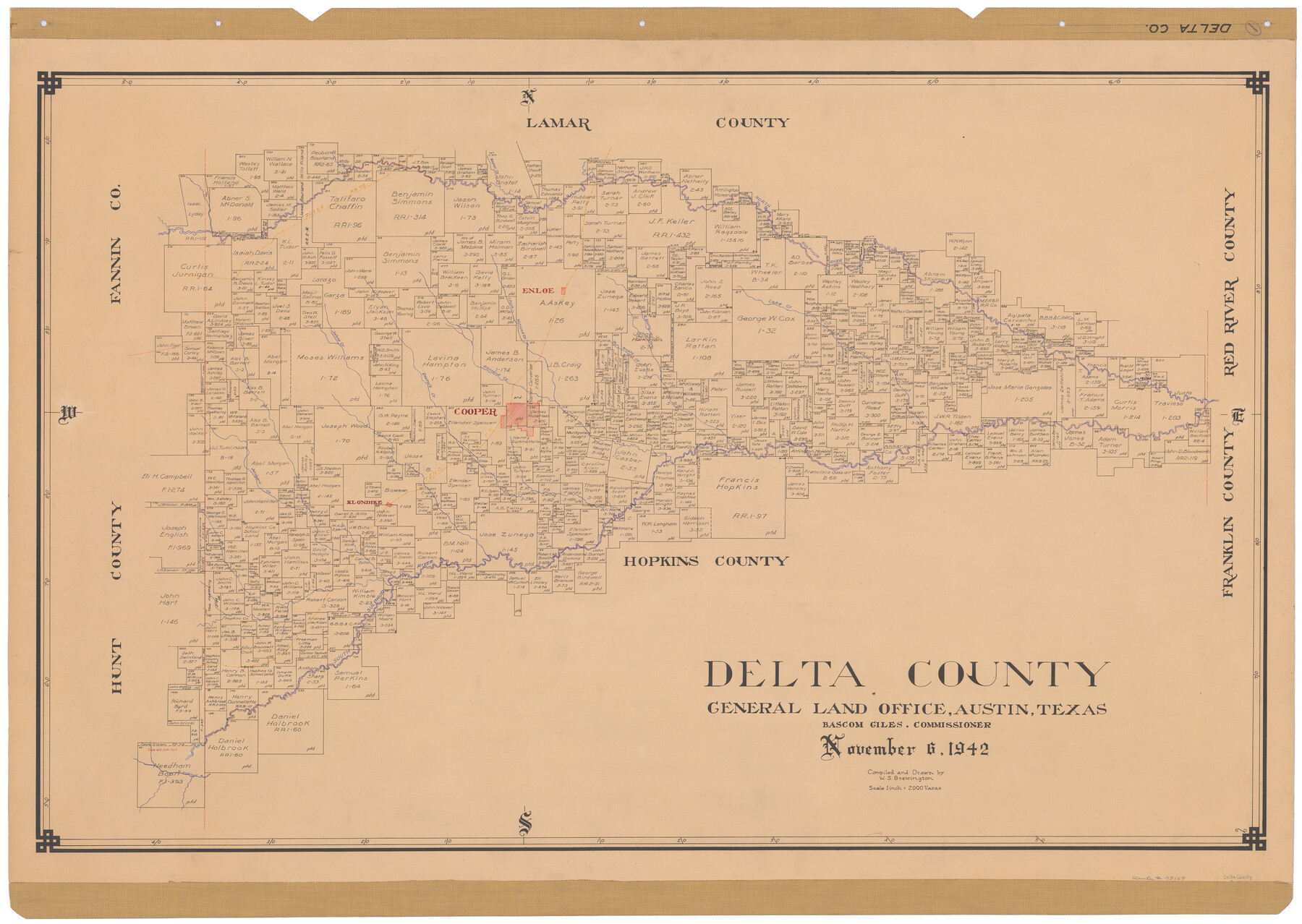
Delta County
-
Map/Doc
73129
-
Collection
General Map Collection
-
Object Dates
1942/11/6 (Creation Date)
-
People and Organizations
Texas General Land Office (Publisher)
Bascom Giles (GLO Commissioner)
W. S. Brewington (Compiler)
W. S. Brewington (Draftsman)
-
Counties
Delta
-
Subjects
County
-
Height x Width
28.6 x 39.0 inches
72.6 x 99.1 cm
-
Comments
Hand lettered.
See counter number 80118 for reverse side of map.
Placed in official use January 8, 1943. -
Features
Roxton Creek
North Sulphur River
Lake Creek
East Brushy Creek
West Brushy Creek
Enloe
East Fork of Richland Creek
Richland Creek
Johns Creek
Doctor's Creek
Jurnigans [sic] Creek
T&NO
Cooper
Klondike
South Sulphur River
GC&SF
Part of: General Map Collection
Franklin County Working Sketch Graphic Index

Print $20.00
- Digital $50.00
Franklin County Working Sketch Graphic Index
1942
Size 40.3 x 16.2 inches
Map/Doc 76546
[Map of Hidalgo County]
![6207, [Map of Hidalgo County], General Map Collection](https://historictexasmaps.com/wmedia_w700/maps/6207.tif.jpg)
Print $20.00
- Digital $50.00
[Map of Hidalgo County]
1882
Size 26.0 x 19.9 inches
Map/Doc 6207
Map of Duval County

Print $20.00
- Digital $50.00
Map of Duval County
1876
Size 29.6 x 21.5 inches
Map/Doc 3498
Map of Unsurveyed Bed of Spring Creek

Print $40.00
- Digital $50.00
Map of Unsurveyed Bed of Spring Creek
1920
Size 78.7 x 27.1 inches
Map/Doc 65695
Mills County Boundary File 5b

Print $8.00
- Digital $50.00
Mills County Boundary File 5b
Size 14.2 x 8.7 inches
Map/Doc 57307
Hemphill County Rolled Sketch 17

Print $20.00
- Digital $50.00
Hemphill County Rolled Sketch 17
1965
Size 27.8 x 36.1 inches
Map/Doc 6197
Crockett County Rolled Sketch 88K

Print $40.00
- Digital $50.00
Crockett County Rolled Sketch 88K
1973
Size 43.0 x 57.4 inches
Map/Doc 8735
Flight Mission No. BRE-2P, Frame 22, Nueces County

Print $20.00
- Digital $50.00
Flight Mission No. BRE-2P, Frame 22, Nueces County
1956
Size 18.7 x 22.6 inches
Map/Doc 86731
Fort Bend County Sketch File 5

Print $4.00
- Digital $50.00
Fort Bend County Sketch File 5
Size 8.2 x 13.0 inches
Map/Doc 22889
Map of Texas Gulf Coast and Continental Shelf showing Natural Gas Pipe Lines

Print $40.00
- Digital $50.00
Map of Texas Gulf Coast and Continental Shelf showing Natural Gas Pipe Lines
1983
Size 40.9 x 59.1 inches
Map/Doc 75969
Map of Henderson County

Print $20.00
- Digital $50.00
Map of Henderson County
1871
Size 16.0 x 31.4 inches
Map/Doc 3665
Tom Green County Sketch File 14

Print $20.00
- Digital $50.00
Tom Green County Sketch File 14
Size 34.8 x 45.7 inches
Map/Doc 10401
You may also like
University of Texas System University Lands

Print $20.00
- Digital $50.00
University of Texas System University Lands
1929
Size 23.2 x 17.7 inches
Map/Doc 93246
Flight Mission No. CRC-4R, Frame 80, Chambers County

Print $20.00
- Digital $50.00
Flight Mission No. CRC-4R, Frame 80, Chambers County
1956
Size 18.6 x 22.4 inches
Map/Doc 84884
No. 2 Chart of Corpus Christi Pass, Texas

Print $20.00
- Digital $50.00
No. 2 Chart of Corpus Christi Pass, Texas
1878
Size 18.2 x 27.3 inches
Map/Doc 73017
Wichita County Sketch File 34

Print $6.00
- Digital $50.00
Wichita County Sketch File 34
1949
Size 14.4 x 8.8 inches
Map/Doc 40154
Roberts County Boundary File 2

Print $12.00
- Digital $50.00
Roberts County Boundary File 2
Size 9.9 x 6.4 inches
Map/Doc 58333
Flight Mission No. BRA-7M, Frame 35, Jefferson County

Print $20.00
- Digital $50.00
Flight Mission No. BRA-7M, Frame 35, Jefferson County
1953
Size 18.7 x 22.4 inches
Map/Doc 85486
Bowie County Working Sketch 29

Print $20.00
- Digital $50.00
Bowie County Working Sketch 29
1991
Size 36.9 x 47.7 inches
Map/Doc 67433
Rusk County Rolled Sketch 8

Print $20.00
- Digital $50.00
Rusk County Rolled Sketch 8
1959
Size 22.6 x 26.3 inches
Map/Doc 7544
Flight Mission No. DQO-8K, Frame 11, Galveston County

Print $20.00
- Digital $50.00
Flight Mission No. DQO-8K, Frame 11, Galveston County
1952
Size 18.7 x 22.3 inches
Map/Doc 85134
University Lands Blocks 27 & 28, Pecos County

Print $20.00
- Digital $50.00
University Lands Blocks 27 & 28, Pecos County
1940
Size 33.6 x 21.1 inches
Map/Doc 2449
Terrell County Sketch File 4

Print $12.00
- Digital $50.00
Terrell County Sketch File 4
1881
Map/Doc 12417
Jackson County Rolled Sketch 2

Print $20.00
- Digital $50.00
Jackson County Rolled Sketch 2
Size 14.1 x 17.9 inches
Map/Doc 6335