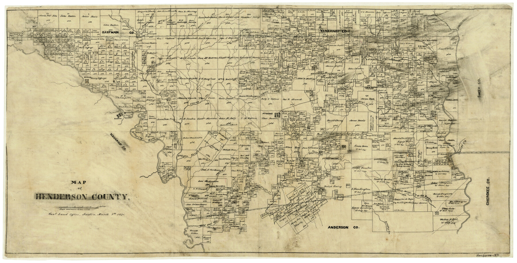
Map of Henderson County
-
Map/Doc
3665
-
Collection
General Map Collection
-
Object Dates
3/8/1871 (Creation Date)
-
Counties
Henderson
-
Subjects
County
-
Height x Width
16.0 x 31.4 inches
40.6 x 79.8 cm
-
Features
Caddo Bayou
Caney Creek
Phantom
Bazett
Buffalo
Trinity River
Walnut Creek
Racoon Creek
Gold Creek
Mulberry Creek
Saline Creek
North Caney Creek
Otter Creek
Clark's Creek
Turkey Creek
Wild Cat Creek
Catfish Creek
Brushy Creek
Pottawatomy Creek
Rock Creek
Sway Creek
Murchison Creek
Cedar Creek
Lucy's Fork [of Kickapoo Creek]
Twin Creek
Purty's Creek
Aligator Creek
Copperas Creek
West Fork [of Kickapoo Creek]
East Fork of Kickapoo Creek
Creamlevel Creek
Beaver Creek
Bridge Creek
Kikapoo [sic] Creek
Battle Creek
Red Bud Creek
Prairie Creek
Indian Creek
Neches River
Flat Creek
Duncan Creek
Athens
Part of: General Map Collection
Gregg County Working Sketch 9

Print $20.00
- Digital $50.00
Gregg County Working Sketch 9
1939
Size 20.3 x 34.8 inches
Map/Doc 63275
Leon County Working Sketch 61

Print $20.00
- Digital $50.00
Leon County Working Sketch 61
2010
Size 35.8 x 38.7 inches
Map/Doc 89986
Geographical, Statistical, and Historical Map of Mexico

Print $20.00
- Digital $50.00
Geographical, Statistical, and Historical Map of Mexico
1822
Size 18.0 x 22.4 inches
Map/Doc 95694
Bandera County Rolled Sketch 9

Print $20.00
- Digital $50.00
Bandera County Rolled Sketch 9
Size 21.2 x 24.2 inches
Map/Doc 5120
Kinney County Rolled Sketch 3

Print $20.00
- Digital $50.00
Kinney County Rolled Sketch 3
Size 31.4 x 23.2 inches
Map/Doc 6535
Edwards County Rolled Sketch 9

Print $20.00
- Digital $50.00
Edwards County Rolled Sketch 9
1885
Size 29.3 x 42.8 inches
Map/Doc 5802
Parker County Working Sketch 12

Print $20.00
- Digital $50.00
Parker County Working Sketch 12
1974
Map/Doc 71462
Galveston County Rolled Sketch 39

Print $20.00
- Digital $50.00
Galveston County Rolled Sketch 39
Size 18.1 x 21.5 inches
Map/Doc 45207
Bowie County Sketch File 8e

Print $12.00
- Digital $50.00
Bowie County Sketch File 8e
1928
Size 8.0 x 5.2 inches
Map/Doc 14896
Orange County Sketch File 4a

Print $22.00
- Digital $50.00
Orange County Sketch File 4a
1874
Size 16.0 x 13.0 inches
Map/Doc 33309
[Plat and field notes of 3.107 acre tract for Clement Cove Harbor Company]
![60397, [Plat and field notes of 3.107 acre tract for Clement Cove Harbor Company], General Map Collection](https://historictexasmaps.com/wmedia_w700/maps/60397-1.tif.jpg)
Print $20.00
- Digital $50.00
[Plat and field notes of 3.107 acre tract for Clement Cove Harbor Company]
1987
Size 24.2 x 36.5 inches
Map/Doc 60397
Parker County Sketch File 9

Print $4.00
- Digital $50.00
Parker County Sketch File 9
Size 8.1 x 10.0 inches
Map/Doc 33538
You may also like
Nueces County Rolled Sketch 68A

Print $165.00
- Digital $50.00
Nueces County Rolled Sketch 68A
1980
Size 9.8 x 15.0 inches
Map/Doc 47898
[Map of Uvalde County]
![4108, [Map of Uvalde County], General Map Collection](https://historictexasmaps.com/wmedia_w700/maps/4108.tif.jpg)
Print $20.00
- Digital $50.00
[Map of Uvalde County]
1862
Size 27.7 x 26.7 inches
Map/Doc 4108
Township No. 5 South Range No. 10 West of the Indian Meridian

Print $20.00
- Digital $50.00
Township No. 5 South Range No. 10 West of the Indian Meridian
1874
Size 19.2 x 24.5 inches
Map/Doc 75161
Hale County Boundary File 2

Print $4.00
- Digital $50.00
Hale County Boundary File 2
Size 10.9 x 8.8 inches
Map/Doc 54044

Pecos County Rolled Sketch 25B

Print $20.00
- Digital $50.00
Pecos County Rolled Sketch 25B
1892
Size 22.2 x 16.0 inches
Map/Doc 7210
Val Verde County Sketch File 2

Print $8.00
- Digital $50.00
Val Verde County Sketch File 2
1885
Size 12.8 x 8.0 inches
Map/Doc 39169
Edwards County Sketch File 40

Print $20.00
- Digital $50.00
Edwards County Sketch File 40
1940
Size 20.4 x 14.3 inches
Map/Doc 11438
Edwards County Working Sketch 22

Print $20.00
- Digital $50.00
Edwards County Working Sketch 22
1938
Size 15.3 x 18.5 inches
Map/Doc 68898
Flight Mission No. BRE-2P, Frame 132, Nueces County

Print $20.00
- Digital $50.00
Flight Mission No. BRE-2P, Frame 132, Nueces County
1956
Size 18.4 x 22.5 inches
Map/Doc 86805
[Surveys in the Robertson District along the Trinity River and Richland Creek]
![104, [Surveys in the Robertson District along the Trinity River and Richland Creek], General Map Collection](https://historictexasmaps.com/wmedia_w700/maps/104.tif.jpg)
Print $20.00
- Digital $50.00
[Surveys in the Robertson District along the Trinity River and Richland Creek]
1841
Size 15.3 x 12.2 inches
Map/Doc 104
Walker County Working Sketch 7

Print $20.00
- Digital $50.00
Walker County Working Sketch 7
1935
Size 38.3 x 43.2 inches
Map/Doc 72287